Military reference books and manuals (2009-2023, Volume 8) - page 46

356
environment-specific civil
357
information architecture. This
358
provides a framework for
359
systematically analyzing conditions
360
and changes in the operating
361
environment. Identifying operating
362
environment-specific civil
363
information architecture is critical
364
for managing civil information, and
365
can be accomplished using the
366
following guidelines:
367
1.
Reference JP 2-01.3, JIPOE,
368
appendix C, section B,
369
Typical PMESII Systems
370
and Subsystems for the
Figure 3-5. Joint Operation Planning Activities, Functions, and Products
371
initial structure of civil information architecture.
372
2.
Populate the initial structure using the civil baseline of the operating environment that was developed
373
during planning from historical, cultural, political, economic, and other information.
374
3.
Adjust PMESII subsystems so that they appropriately represent the culture, political system, economic
375
system, infrastructure, and information media in the operating environment. This is accomplished using
376
analytical frameworks and technical architecture to identify relative weight and relationships of
377
subsystem components, both within PMESII systems and across them.
378
a. Recommended analytical frameworks include techniques, frameworks, data collected, and analyses
379
conducted by civilian political scientists, economists, civil and municipal planners and engineers, and
380
other SMEs who plan and direct civil programs for governments.
381
b. Technical architectures necessary can be defined by identifying components of analytical frameworks
382
employed to understand the civil components of the operating environment.
383
4.
Populate civil information architecture with current conditions based on effects, decisive points, and other
384
military and stakeholder activity in the operating environment.
385
5.
Associate LOOs with related PMESII systems and populate civil information architecture with mission
386
success and termination criteria for each LOO.
387
6.
Associate operational requirements with historical and current conditions using the civil information
388
architecture.
389
a. Identify the people, processes, and technologies that comprise the civil components of the operating
390
environment as links, nodes, and COGs.
391
b. Identifying COGs requires understanding conditions while relating operational/strategic objectives to
392
those conditions. The nature and functions of nodes and their interrelationships provide the basis for
393
determining COGs. Knowing COGs and their relationships provide the basis for developing IRs that
394
support planning and targeting, and enable developing systems-oriented event templates that
395
facilitate mission planning and execution.
3-12
396
c. Conduct effects-based planning leveraging targets identified through analytical systems, such as
397
PMESII or LOOs, incorporated into the civil information architecture.
398
These additional best practices facilitate planning to manage civil information:
399
1. Plan to manage civil information in and around the AO:
400
a. Subordinate echelon enabler and maneuver operations should support the commander’s objectives.
401
b. Stakeholder AOs may not be completely contained within the commander’s O, be flexible in order
402
to support them and maintain a positive, mutually supportive relationship.
403
2. Know who has information, skill sets, or capabilities and be prepared to broker contact among
404
organizations or people who need them:
405
a. Know POCs for every organization that civil information is being shared with.
406
b. Share those POCs with organizations or people who need help.
407
3. Identify all stakeholders requiring information about the civil components of the operating environment.
408
4. Verify relevance of participant as a stakeholder:
409
a.
Conduct pre-meeting analysis by researching organizations, charters, press releases, country of
410
origin, cultures, and so forth of identified stakeholders.
411
b. Know the overarching strategies of all stakeholders involved.
412
c.
Identify mutual goals/end states for each stakeholder.
413
5. Consistently provide concise, analytical, echelon appropriate products that guide decision making.
414
6. Never miss an opportunity to push civil information to other staff with sufficient time for them to
415
incorporate the information into their planning.
416
7. Identify available means to communicate, including direct and indirect means, such as a third party.
417
3.5 Conclusion
418
Planning to manage civil information is a vital element of staff operations. Historically, operations required
419
commanders to focus on friendly and enemy information. Population centric operations require substantial SA of
420
the people, culture and civil conditions in the operating environment. Developing civil information architecture
421
that complements friendly and enemy forces information in C4I systems enables staff to provide accurate and
422
predictive sensemaking of the civil components of the operating environment. Understanding how nodes are
423
interconnected within and between PMESII systems enable commanders to achieve unity of effort and mission
424
success.
1 Counterinsurgency Advisory and Assistance Team, RC-West, Herat, Afghanistan. The Stability Operations
Information Center (SOIC): Comprehensive Understanding for Comprehensive Operations, page 2.
2 Joint Publication 5-0, Joint Operation Planning, 26 December 2006, page III-12.
3 Joint Publication 2-01.3, Joint Intelligence Preparation of the Operational Environment, page II-44.
4 Counterinsurgency Advisory and Assistance Team, RC-West, Herat, Afghanistan. The Stability Operations
Information Center (SOIC): Comprehensive Understanding for Comprehensive Operations, page 6.
5 Chairman of the Joint Chiefs of Staff Instruction (CJCSI) 3100.01A, CJCSI 3122.01 CJCSI 3122.02, CJCSI 3122.03B, JP
3-0 and JP 5-0.
6 Joint Publication 3-0, Joint Operations, 17 September 2006; Incorporating Change 2, 22 March 2010, page IV-26;
Joint Publication 5-0, Joint Operation Planning, 26 December 2006, page IV-34.
7 Joint Publication 3-57, Civil-Military Operations, 8 July 2008, page GL-6.
3-13
8 Joint Publication 3-60, Joint Targeting, 13 April 2007, page I-8.
9 Joint Publication 1-02, Department of Defense Dictionary of Military and Associated Terms, 8 November 2010,
page 364.
10 Joint Publication 3-33, Joint Task Force Headquarters, 16 February 2007, page D-2.
11 Counterinsurgency Advisory and Assistance Team, RC-West, Herat, Afghanistan. The Stability Operations
Information Center (SOIC): Comprehensive Understanding for Comprehensive Operations, page 15.
12 Auburn University. (2005). Supervisor’s Performance Management Toolkit, page 40.
3-14

1
CHAPTER 4 JOINT CIVIL INFORMATION COLLECTION
2
4.0 Introduction
3
Collection is the second step in the joint civil information management
“By the word ‘information’ we
denote all knowledge which we
4
process, and is essential for achieving visible, accessible, and understandable
have of the enemy and his
5
information.1
It facilitates data sharing and making informed decisions. For
country; therefore, in fact, the
6
this to occur, collection is executed for a specific topic to fulfill a specific
foundation of all our ideas and
actions”
7
need. A formal collection process ensures required data is defined, gathered,
8
complete, and accurate. Figure 4.1, Collection Process, depicts three
Carl Von Clausewitz,
On War
9
collection procedures. Collection requirement taskings and planning sub
10
steps are similar for each procedure. Information search, civil
11
reconnaissance, and civil engagement should be synchronized during planning to provide complete, timely, and
12
accurate civil information to decision makers.
13
NOTE: The term “information” refers to data, knowledge, and understanding unless otherwise specified.
14
`
15
Figure 4-1. Collection Process
16
1. Information Search consists of the collection from the internet, printed media, or other civilian or military
17
sources. This collection type is considered indirect collection and may be used for data mining.
18
2. Civil Reconnaissance is planned collection of focused information by direct observation and evaluation of
19
the operating environment.
4-1
20
3. Civil Engagement is dialogue or cultural exchange with
Information search is civil information
21
one or more individuals. It is a participatory interaction,
collection and can be a very efficient way to
satisfy an IR.
22
such as key leader engagement (KLE), mass
23
engagement, and surveys between the collecting unit
Information search helps to determine what
civil information needs to be collected through
24
and the people and organizations being engaged.
the more resource intensive, and potentially
higher risk, direct collection procedures for civil
25
4.0.1 Key Terms
reconnaissance and civil engagement.
26
The following terms are defined within the context of the joint
27
civil information management process:
Information search is not only pulling data from
28
Data are observations, cue detection, recognition of civil
the searching organization’s existing repository
29
situational elements, facts and current status identified
of civil data, but also collecting new or updated
30
by a sensor or collector (human, mechanical, or
civil information from internal and external
sources. This data is required to meet the
31
electronic) from the environment or communicated and
searching organization’s IRs.
32
processed between nodes in any system.
33
Information is the meaning that humans derive from data. This meaning is the outcome of filtering,
34
fusing, formatting, organizing, collating, correlating, plotting, translating, categorizing, and arranging data
35
to make sense of it. Information is only information for the individual requirement it is processed to
36
support; for all other purposes it is just facts or data.
37
4.1 Context
Example: During Operation Iraqi Freedom an
38
Planning provides the purpose, direction, and authority for civil
RFI was sent down from Corps to MND-N three
39
data collection to ensure that complete, accurate, timely, and
times to assess the banks in a specific region.
40
operationally relevant civil data is visible, accessible, and
The first and second RFIs did not specify the
41
understandable to supported elements, higher headquarters,
exact information required. The executing
42
other USG and DoD agencies, IGOs, and NGOs. Collection cannot
units were left to decipher the requirements,
43
be conducted without:
resulting in reports that provided no pertinent
information. The information needed was bank
44
1. Purpose: What is the data being collected to support?
usage, such as payroll distribution, and scale
45
2. Direction: What civil data is will satisfy the purpose?
based on the dimensions of the bank vaults, to
46
CAUTION: If a collection tasking lacks clear purpose and
determine which banks had sufficient capacity
47
direction, refer to the collection plan, or send an RFI to the
to accommodate the large cash volume for
48
tasking authority.
government payrolls.
49
3. Necessary Authority: Do collectors possess the required
The third RFI specifically directed that bank
50
authority to collect data?
vault dimensions, conditions and security be
51
a. Under Title 222
authority, the US Embassy regulates
provided.
52
official communication with HN representatives
Proper purpose and direction was provided in
53
b. Engagements may require coordination through the
the third RFI, which resulted in collection that
54
POLAD and or the POC within the US Mission
satisfied the RFI. The previous two RFIs lacked
55
CAUTION: If a collection tasking requires engaging HN
purpose and direction, which exposed US and
56
officials at the operational or strategic level, ensure that
coalition forces to unnecessary risk from
57
authority for the engagement is coordinated through the
needless missions.
58
POLAD with the US Embassy.
4-2
59
4.2 Information Search
60
Information search is executed at all levels, but is typically concentrated at the operational level and higher. It is a
61
four-step procedure for collecting information from existing sources, and is represented in Figure 4-2, Information
62
Search Procedures. Sources may be physical or digital and found via the internet or from civilian and military
63
partners. Data can be in the form of reports, assessments, or other products. Additionally, means of conveyance
64
may be varied as depicted in step 1a (3) below. Information search is a crucial part of collection that can provide an
65
efficient way to satisfy IRs and helps to determine what civil data needs to be collected through direct collection.
66
NOTE: As a general rule, data collectors should exhaust all existing sources before conducting direct collection.
67
4.2.1 Information Search Considerations
68
There are several considerations associated with data collected through information search. These are important
69
to collecting complete and accurate civil data. These considerations are:
70
Reliability & Credibility: Sources of information have varying degrees of reliability while data types have
71
varying degrees of credibility. All data from information searches must be assessed for reliability
72
concerning the source and credibility of the data. Source Reliability and data credibility should be
73
evaluated and documented IAW standards established in the collection plan, or standard operating
74
procedure (SOP), but when standards are not specified, the framework shown in Table 4-1, Source
75
Reliability, and Table 4-2, Data Credibility,3
can be used.
76
Currency: Evaluate source data to determine the currency of the data. Physical, social and other civil data
77
identified in information search are subject to change over time. Civil information managers should
78
establish currency guidelines based on the perishable nature of the data.
79
Source Documentation: All civil data collected through information search must be documented. This
80
enables analysts and other users of the data to go back to the source if necessary. This is particularly
81
important where the reliability of the source or accuracy of the data is uncertain. Techniques for
82
documenting open internet sources can be found in Army Field Manual (FM) 2-22.9, Appendix I.
83
Data Format(s): Standardized data fields and formats enable more efficient consolidation of data and
84
enables analysts and other stakeholders to effectively correlate and corroborate the data that is
85
consolidated in civil information systems.
86
4.2.2 Information Search Procedures
87
88
Figure 4-2. Information Search Procedures
89
Step 1- Planning to Search. The following steps are used to prepare for information search.
90
a. Determine data requirements:
91
(1) Review tasker and identify data requirements using Figure 4-3, Example Tasker Forms.
4-3

92
(2) Determine the purpose for the data from the tasking. The purpose can provide essential
93
requirements, both specified and implied.
94
(3) Identify all directed or required media using Figure 4-4, Means of Conveyance.
95
CAUTION: If a collection requirement is not clear,
Verbal directive.
96
specific enough or the purpose is not included, send
A specified task in the operations order (OPORD) or
97
an RFI to the tasking authority.
fragmentary order (FRAGO).
98
b. Determine appropriate collection tools:
A collection matrix that is an outcome of the planning
step and is usually conveyed as a list of civil tactical
99
(1) Identify the appropriate civil data collection
goals and tasks matched to operational objectives.
100
forms found in Annex B. Form A, is
Recurring requirements. These include implied
101
mandatory for all collection requirements.
requirements such as a CCIR and battle rhythm inputs
such as situation reports (SITREP) and update briefs.
102
More than one form may be required.
Data shortfalls identified from collection management.
103
(2) Identify the required data fields and their
104
priority on the collection form(s).
Figure 4-3. Example Tasker Forms
105
(3) Identify and become familiar with the standards, such
Photo/Video
Audio
106
as the format, for each required data field.
Digital
Hard Copy
107
NOTE: The standardized data format specified for each data
Files/Records
Documents
Objects and artifacts
108
field is one component of data accuracy. The other
109
component is the accuracy of the data itself.
Figure 4-4. Means of Conveyance
110
CAUTION: If an automated collection tool is used, refer to the system’s TTP to identify data field and
111
data format requirements. Use the forms in Annex B to complement any system specific shortfalls.
112
c. Identify sources:
Table 4-1. Source Reliability
Value
Rating
Description
113
(1) Consider, but do not limit potential sources to the
A
Reliable
No doubt about the
114
following organizations: US and combined forces, US
authenticity,
115
and partner nation agencies, and NGOs.
trustworthiness or
116
(2) Consider, but do not limit sources to the following:
competency of the
source. History of
SITREPS
Staff estimates
complete reliability.
Intelligence updates
Sectarian reports
B
Usually
Minor doubts. History
Law enforcement reports
Media reports
Reliable
of mostly valid data.
Internet search results
Scholarly literature
C
Fairly
Doubts. Provided
Reliable
reliable data in the
117
(3) Prioritize sources to search.
past.
118
(4) Task requirements among available personnel.
D
Not
Significant doubts.
119
Step 2 - Search sources for required civil data:
Usually
Provided valid data in
120
a. Determine how to query the source organization:
Reliable
the past.
Telephone
Email
E
Unreliable
Lacks authenticity,
trustworthiness, and
Online Collaboration
Internet Search
competency. History of
Liaison
invalid data.
121
b. Establish standard procedures among partners for
F
Cannot be
Insufficient
122
repetitive data searches and sharing.
Judged
information to
123
c. Search to satisfy all data fields identified in Step 1b.
evaluate - may or may
not be reliable.
124
d. When required data located, record the source of the data:
125
(1) Non-internet sources, record author, organization, title, publication, date, and retrieval date.
4-4
126
(2) Internet site sources, record the author, organization, title, publication or posting date, retrieval
127
date, and uniform resource locator (URL) of the information.
128
Step 3 - Record civil data:
Table 4-2. Data Credibility
129
a. Generate a digital or paper copy of the data collection form.
Rating
Rating
Rating description
Value
130
b. Complete the required fields on the data collection form.
131
c. Follow the data format standards in the data collection form.
1
Confirmed
Logical, consistent
with other relevant
132
d. Append supporting documents to the data collection form.
data, confirmed by
133
e. Maintain classification of civil data at the lowest level
independent
134
authorized. Appropriately marking unclassified data is critical
sources.
135
to meet the principle of accessibility.4
2
Probably
Logical, consistent
136
NOTE: Following the data format standards makes data
True
with other relevant
data, but not
137
consolidation more efficient.
confirmed.
138
Step 4 -QA/QC the recorded data:
3
Possibly
Reasonably logical,
139
a. Verify completeness and accuracy of all available and
True
agrees with some
140
required civil data collected from the source.
relevant data, but
141
b. Verify all supporting documents are attached to the data
not confirmed.
142
collection form.
4
Doubtfully
Not logical but
143
c. Verify the source is correctly documented.
True
possible, no other
data on the subject,
144
d. Verify all data is recorded IAW the data formats specified in
and not confirmed.
145
the data collection form.
5
Improbable
Not logical,
146
e. Verify that data collected fulfills requirements in the
contradicted by
147
collection tasking.
other relevant data.
148
4.2.3 Information Search Best Practices
6
Cannot be
The validity of the
149
The following information search best practices are lessons learned
Judged
data can not be
determined.
150
derived from deployed units and from input by SMEs:
151
1. A collection planning best practice is to answer the questions in Table 4-3, Questions for Planning.
Table 4-3. Questions for Planning
Sequence #
Planning question
Search, Collection, Research activity
1
What do we need to know?
query, question
2
How are we going to collect it?
design
3
Who needs the information and by when?
deliverable
4
How are we going to get it there?
fields, format & distribution
152
153
2. Maintain a list of useful and trusted sources. Modify the list as organizations enter and leave the AO. An
154
initial list of unclassified internet sources is provided in Annex A, Quick Reference Guide.
155
3. Be aware of what types of data are maintained by various mission partners. Develop a sharing strategy or
156
plan with the partnering stakeholders, IAW the procedures in Chapter 8.
157
NOTE: Users must adhere to a SOP for meta-tags, references and naming conventions.
158
4. Save complete back-up copies of files and record the location of source material to ensure accessibility.
4-5

159
5. Review and acquire all civil data from the AO when conducting RIP/TOA. Capturing relevant civil data
160
during RIP/TOA ensures continuity of effort that is essential to mission success.
161
4.3 Civil Reconnaissance
162
Civil reconnaissance is a four-step procedure that involves the collection of civil data directly from the operating
163
environment. It is represented in Figure 4-5, Civil Reconnaissance Procedures, and is the focused, planned, and
164
coordinated observation and evaluation of the civil population and the physical aspects of the operating
165
environment. Civil reconnaissance fills gaps in the collection plan indentified during information search and is
166
conducted concurrently with civil engagements or other operations, actions, and activities. Civil reconnaissance is
167
conducted primarily at the tactical level by forces in direct contact with IPIs.
168
4.3.1 Civil Reconnaissance Considerations
169
When conducting civil reconnaissance there are three primary considerations:
170
1. Integration: Multiple assets within the joint force collect data on various aspects of the operating
171
environment. Civil reconnaissance is normally conducted concurrently with civil engagement. Forces
172
conducting civil reconnaissance can include force enablers and functional area specialists. Non-military
173
stakeholder organizations operating in the AO and may be collecting as well. Integration occurs when civil
174
reconnaissance is coordinated with the supported unit staff and other stakeholders. This coordination
175
should include operational details of the mission, which aids in de-conflicting available resources, such as
176
transportation and security, and promotes synergy among stakeholders.
177
2. Timeliness: Civil reconnaissance is subject to affects of friendly and threat operations as well as
178
unforeseeable changes in the environment.
179
NOTE: Planning civil reconnaissance to meet reporting timelines should take into account uncontrolled
180
operational and environmental factors.
181
3. Opportunity Collection: This occurs when friendly forces moving about the operational area come upon
182
aspects of the operating environment that are of interest or fulfill IRs. Be prepared to collect civil data
183
when unplanned collection opportunities occur. Pre-mission information search provides e information
184
about the AO and its people to guide actions when encountering these situations.
185
4.3.2 Civil Reconnaissance Procedures
186
187
Figure 4-5. Civil Reconnaissance Procedures
188
Step 1- Mission Planning. The following steps prepare for civil reconnaissance.
189
a. Determine the data requirements:
190
(1) Review tasker and identify data requirements using Figure 4-3, Example Tasker Forms.
4-6
191
(2) Determine the purpose for the data from the tasking.
192
(3) Identify all directed media requirements. Examples are in Figure 4-4, Means of Conveyance.
193
CAUTION: If a collection tasking is not clear and does not include purpose, RFI the tasking authority to
194
clarify the purpose for the data. The purpose can provide information to clarify the requirement.
195
b. Determine appropriate collection tools.
TLP Mission Environment
196
(1) Identify the appropriate civil data collection form in
Social Considerations
197
Annex B. One or several forms may be required
Recent Friendly Actions
198
depending on the scope of the tasking
Recent Threat Actions
Risk Assessment.
199
(2) Gather any other required material and references (e.g.
TLP Mission Plans
200
measuring tools).
Routes
201
(3) Identify all required fields on the collection form.
Security
202
(4) Identify and familiarize yourself with the data standards
Communications
203
within each required data field.
Emergency Procedures
204
NOTE: Standardized data formats specified for each data field is
TLP Team Assignments
205
one component of data accuracy; the other is accuracy of the
Recordings/Transcriptions
206
data itself.
Photographs
207
CAUTION: If an automated collection tool is used, refer to the
Collection Forms/Automated Tools
Translation
208
system TTP to identify data field and format requirements. Use
209
Annex B to compliment any shortfalls.
Figure 4-6. Troop Leading
210
c. Conduct TLP:
Procedures
211
(1) Understand the collection environment using factors in Figure 4-6, TLP Mission Environment.
212
(2) Plan the mission using Figure 4-6, TLP Mission Plans.
213
(3) Assign the collection responsibilities within the team using Figure 4-6, TLP Team Assignments.
214
(4) Rehearse the mission, including data collection, and data handling.
215
(5) Issue the order.
216
(6) Conduct pre-combat inspections (PCI)/pre-combat checks (PCC).
217
Step 2 - Conduct civil reconnaissance for required civil data:
218
a. Collect data for all data fields identified in STEP 1b, using appropriate collection tools as required.
219
b. Collect civil information, using directed media requirements, in Figure 4-4, Means of Conveyance.
220
c. Create opportunities to interact with the local populace. These can be planned future engagements
221
or ad hoc meetings added to this mission. In either case use civil engagement procedures as required.
222
WARNING: Social or technical issues may preclude use of automated collection tools. Be prepared to
223
manually record data.
224
Step 3 - Record civil data on data collection forms (usually at close of mission):
225
a. Prepare a digital or paper copy of the collection form.
226
b. Complete all required fields on the selected data collection form.
227
c. Follow the data format standards in the data collection form.
228
d. Append supporting documents to the data collection form.
229
e. Maintain classification of civil data at the lowest level authorized.
230
NOTE: Following data format standards makes data consolidation more efficient.
231
Step 4 - Perform QA/QC on recorded data:
4-7
232
a. Verify that all available and relevant civil data was collected from the reconnaissance objective.
233
b. Verify that all recorded data is IAW the data formats in the data collection form.
234
c. Verify that translations are accurate when possible.
235
d. Validate data and verify that data collected fulfills requirements in the collection plan.
236
e. Verify that all supporting documents are appended to the collection form, and ensure compliance
237
with file naming conventions
238
4.3.3 Civil Reconnaissance Best Practices
239
The following are best practices for data collection via civil reconnaissance:
240
a. Mission Planning: Answer the questions identified in Table 4-3, Questions for Planning.
241
b. Collecting Atmospherics: When collecting data throughout the reconnaissance route it is important
242
to note abnormalities in social behavior in relation to the local populace. Example: As you enter a
243
village you’ve been to before you see children leave the area around you. You recognize this is a
244
change from previous missions at this location so it should be noted.
245
c. Manually Recording Civil Data: The advantage of manually recording civil data is that it requires
246
minimal note taking skills and has no requirement for the technical training required for an
247
automated collection tool. nnex B contains 8.5” x 11” versions of the assessment forms that can be
248
utilized during data collection to provide a reference for what to collect and how to record data.
249
CAUTION: Ensure that no classified material is recorded in Annex B forms or leader books.
250
d. Automated Versus Manual Collection: Automated collection tools are an effective means to record
251
and report civil data. Social considerations, as noted in Step 2, or technical issues may preclude the
252
use of these tools. In those circumstances, use the manual forms in Annex B to initially collect civil
253
data. Input data into the collection/consolidation device when time and conditions permit.
254
NOTE: Ensure that backup power for automated collection tools is added to your list of PCI/PCC.
255
e. Cameras: A camera needs to be rugged if it is used in a tactical environment. Its use should not draw
256
unwanted attention. In addition to the physical features of the camera, it should have the ability to
257
encode the image data with the date and time. Listed below are recommended camera capabilities:
(1) A date/time group (DTG) stamp function
(2) Minimum 10 megapixel resolution
(3) A flash that can be turned off
(4) A removable data storage media
(5) Common battery capabilities
(6) GPS stamp function
258
NOTE: Understand the capabilities, limitations, and functionality of collection equipment.
259
4.4 Civil Engagement
260
Civil engagement consists of a four-step procedure for collecting civil data from people about the operating
261
environment. It is represented in Figure 4-7, Civil Engagement Procedures, and entails direct interaction between
262
the collecting unit and IPIs to collect data about the operating environment. Primary sources for civil engagement
263
are people with knowledge of or influence among the civil population. Civil engagement may be a necessary
264
precursor to other activities in an area, and is primarily conducted at the tactical level by forces in contact with
265
IPIs. In the context of the joint civil information management, the ways to engage the civilian population include:
266
1. KLE: One-on-one or small group interaction. These are normally done with individuals who have a degree
267
of authority or responsibility.
4-8
268
2. Mass Engagement: Interaction with a large assembly of people. These range from large meetings, through
269
civil events, to social activities.
270
3. Surveys: A method to interact with any number of people. Surveys enable collection of large amounts of
271
data that may be difficult to acquire by other means.
272
4.4.1 Civil Engagement Considerations
273
Civil engagements are a form of direct collection where the collector is acquiring data from meetings between
274
people. Effective communication is essential to maintaining successful dialogue. This will often take place within
275
meetings that may be informal and spontaneous or routine and structured. The considerations for civil
276
reconnaissance apply to civil engagement, but there are additional factors associated with civil engagement:
277
1. Social Customs: Most US military operations are conducted on foreign soil. Consequently, service
278
members must be knowledgeable of IPI customs.
279
NOTE: The actions and activities that convey respect for local customs play a decisive role in the mission.
280
2. Language: When service members lack the ability to communicate effectively with the local populace, a
281
properly vetted and trained interpreter should be used.
282
NOTE: The proper use and supervision of interpreters is essential.5
283
3. Opportunity Collection: Friendly forces will often have unplanned interactions with IPIs. Be prepared to
284
collect civil data to standard during such unplanned collection opportunities.
285
WARNING: Exercise caution during engagements. Operational security (OPSEC) measures reduce the risk of
286
compromising operations or the safety of military, civilian, and HN partners.
4-9

287
4.5.2 Civil Engagement Procedures
288
289
Figure 4-7. Civil Engagement Procedures
290
Step 1- Mission Planning. The following steps are used to prepare for civil engagements:
291
a. Determine data requirements:
292
(1) Review tasker and identify data requirements using Figure 4-3, Example Tasker Forms.
293
(2) Determine the purpose for the data from the tasking.
294
(3) Identify all directed media requirements using Figure 4-4, Means of Conveyance.
295
CAUTION: If a collection tasking does not define the purpose, send a RFI to the tasking authority.
296
b. Determine appropriate collection tools:
297
(1) Gather required material and references.
298
(2) Identify the appropriate civil data collection form(s) from Annex B. One or several forms may be
299
required depending on the
300
scope of the tasking.
301
(3) Identify the required data fields and their priority on the collection forms.
302
(4) Identify and familiarize yourself with the data standards within each required data field.
303
NOTE: Standardized formats specified in the forms is one component of data accuracy. The other is the
304
accuracy of the data itself.
4-10
305
CAUTION: If automated collection tools are used refer to the system TTP to identify data field and data
306
format requirements. Use the forms in Annex B to compliment any system specific shortfalls.
307
c. Conduct TLP:
308
(1) Understand the collection environment using Figure 4-6, TLP Mission Environment.
309
(2) Plan the mission and consider Figure 4-6, TLP Mission Plans.
310
(3) Assign the collection responsibilities within the team using Figure 4-6, TLP Team Assignments.
311
(4) Issue the order.
312
(5) Rehearse the mission, including preparing the translator, data collection, and data handling.
313
(6) Conduct PCI/PCC.
314
Step 2 - Conduct civil engagement.
315
a. Conduct the engagement IAW the appropriate sub-steps:
Step 2a: KLE
Step 2b: Mass Engagement
Step 2c: Conduct Survey
316
b. Create new opportunities to interact with the local civilians.
317
Execute civil engagement procedures as required
318
c. Review relevant stakeholder assessment frameworks for additional collection considerations.6
319
NOTE: More than one of these sub-steps can be conducted for the civil engagement.
320
CAUTION: Carefully manage the amount of recorded data; both audio and video, to ensure that it can
321
be consolidated. Collectors need to prioritize the data and avoid excess information.
322
WARNING: Social considerations or technical issues may preclude use of automated collection tools. Be
323
prepared to manually record data.
324
Step 2a - Conduct a KLE:
325
(1) Position all data collectors including:
Photographer
Recorder/Transcriber(s)
Interpreter(s)
326
(2) Establish the meeting objectives with the participants.
327
(3) Determine the key leader’s goals and objectives.
328
(4) Distribute supporting documents.
329
(5) Collect civil information. See Figure 4-4, Means of Conveyance.
330
(6) Arrange to meet other persons with required/related information.
331
(7) Arrange future meeting with the key leader.
332
Step 2b - Conduct a mass engagement:
333
NOTE: Mass engagements may require multiple collection tools and personnel to cover the entire event.
334
(1) Position all data collectors including:
Photographer(s)
Recorder/Transcriber(s)
Interpreter(s)
335
(2) Establish objectives with participant(s) when necessary.
336
(3) Distribute supporting documents.
337
(4) Set up visual aids.
338
(5) Interact to collect civil information, using Figure 4.4, Means of Conveyance.
339
(6) Arrange future mass engagements with selected persons.
340
Step 2c - Conduct a survey:
341
CAUTION: Surveys are a special form of engagement that requires coordination with human terrain
342
teams, military information support, and civil affairs before administering.
4-11
343
(1) Position the survey administrators and translators.
344
(2) Establish the survey objectives with the participants.
345
(3) Distribute the survey.
346
(4) Establish the time limit for completing the survey.
347
(5) Facilitate the completion of the survey by the participants.
348
(6) Collect additional civil data by interacting with local civilians.
349
(7) Collect the completed surveys and screen them for completeness.
350
NOTE: Referrals for future engagements may present themselves before, during, or after surveys.
351
Step 3 - Record civil data on data collection forms (usually at close of mission):
352
a. Prepare a digital or paper copy of the collection form.
353
b. Complete the required fields on the selected data collection form.
354
c. Translate the data as required.
355
d. Follow the data format standards on the data collection form.
356
e. Append supporting documents to the data collection form.
357
f.
Maintain classification of civil data at the lowest level authorized. Appropriately marking unclassified
358
data is critical to meet the principle of accessibility.
359
NOTE: Following the data format standards makes data consolidation more efficient.
360
Step 4 -Perform QA/QC on recorded data:
361
a. Verify that all available, relevant civil data collected from the engagement is complete and accurate.
362
b. Verify that all recorded data is IAW the data formats specified in the data collection form.
363
c. Verify that the translations are accurate.
364
d. Verify that all required ancillary media is appended to the data collection form and ensure
365
compliance with the file naming conventions.
366
e. Verify that all supporting documents are appended to the data collection form and ensure
367
compliance with the file naming conventions.
368
f.
Verify that data collected fulfills requirements in the collection plan.
369
NOTE: Q/C is the last step in the civil engagement procedure. IF all data requirements are satisfied,
370
continue the CIM process. IF all data requirements are not satisfied, conduct additional collection.
371
4.4.3 Civil Engagement Best Practices
372
The following are the best practices for civil engagement.
373
1. Mission Planning: Answer the questions identified in Table 4-3, Questions for Planning.
374
2. Collecting Atmospherics: Collect as you would for civil reconnaissance see 4.3.3b.
375
3. Maintain Purpose: The following points apply when conducting engagements:
376
a. Stay focused on collecting answers that satisfy IRs, not allowing subjects to sidetrack the discussion.
377
b. Do not make value judgments.
378
c. Be attentive to the individual’s intellect and education level. Use clear and concise vocabulary.
379
d.
ctively listen and display a genuine interest in the individual’s ideas and opinions.
380
e. Convey sincerity and avoid appearing superficial.
381
f.
Be attentive to the level of trust between participants.
382
g. Select questions in order to bond with the participant(s).
4-12
383
h. Do not promise what cannot be delivered.
384
4. Assessing sources: Assess the reliability of individuals and accuracy of information during engagements to
385
distinguish objective and factual information from inaccurate information. A rating system is provided for
386
collectors and consolidators of civil data in Table 4-1, Source Reliability, and Table 4-2, Data Credibility.
387
The forms in Annex B provide a location to record the assessment of the source.
388
5. Use of Interpreters: Appendix C of Multi-Service Tactics, Techniques, and Procedures for Conducting Peace
389
Operations, provides guidance for selection, training, and use of interpreters.
390
6. Event Arrival: Be highly sensitive to OPSEC and IPI social norms when conducting civil engagement.
391
4.5 Collection for Project Data
392
Projects provide a special environment where collection is conducted that affords opportunities to influence the
393
operating environment. This is a C2 activity that entails observation of on-going projects and reporting aspects of
394
project status to commanders and project managers. Civil collectors are often in a position to assist in the task of
395
nominating potential projects and monitoring progress of on-going projects. Project management provides
396
opportunity for access to and influence over a civil population. During collection joint forces should be sensitive to
397
conditions that may be improved by potential projects.
398
The need for potential projects or information about existing projects may arise during civil reconnaissance or civil
399
engagement. The collector should record information about these projects and what affect the project will likely
400
have or does have on various constituencies. Potential projects may be nominated based on civil information
401
collected. In this context, civil collectors are not managing projects but assisting them by reporting their status.
402
Often times civil data collectors may report on projects outside their organization. Such projects may be under the
403
control or contract of other USG agencies, such as USAID, or multi-national organizations or non-governmental
404
organizations. Providing status reports of these projects to their field offices that are often times dislocated from
405
the project site can help promote greater cooperation and information sharing between the stakeholders.
406
4.6 Conclusion
407
Joint civil information collection is accomplished with synchronized information search, civil reconnaissance, and
408
civil engagement. Successful collection occurs when collected data: satisfies the collection plan, collection
409
requirement, or RFI; is reported in a way that facilitates consolidation; enables informed decisions; and can be
410
disclosed to agencies with a requirement to know. Ultimately, accurate collected civil data shapes the success of
411
the subsequent step, consolidation.
1 DoDD 8320.02, Data Sharing in a Net-Centric Department of Defense, page 2.
2 Title 22, United States Code, Foreign Relations and Intercourse
3 Joint Publication 2-01, Joint and National Intelligence Support to Military Operations, 07 October 2004, page
III-35.
4 Executive Order (EO) 13526, Classified National Security Information; EO 13556, Controlled Unclassified
Information; Department of Defense Instruction (DoDI) 5200.01, DoD Information Security (INFOSEC) Program and
Protection of Sensitive Compartmented Information (SCI); DoD 5200.1-PH, Guide to Marking Classified Documents;
DoD 5200.1-R, INFOSEC Program; DoDD 5205.02, DoD OPSEC Program; DoD Manual 5205.02-M, DoD OPSEC
Program Manual; and Directive-Type Memorandum, Security Classification Marking Instructions.
4-13
5 Field Manual 3-07.31/Marine Corps Warfighting Publication 3-33.8/Air Force Tactics, Techniques, and Procedures
3-2.40 Multi-Service Tactics, Techniques, and Procedures for Conducting Peace Operations, October 2003,
Incorporating Change 1, April 2009.
6 United Nations High Commissioner for Refugees, The UNHCR Tool for Participatory Assessment in Operations,
May 2006. http://www.unhcr.org/450e963f2.html
4-14

1
CHAPTER 5 JOINT CIVIL INFORMATION CONSOLIDATION
2
5.0 Introduction
“[International Security Assistance Force]
3
Consolidation is the third step in the joint civil information
ISAF must develop effective assessment
4
management process. The purpose of the step is to organize and filter
architectures, in concert with civilian
5
civil data to process it into civil information. Data consolidation is an
partners and home nations, to measure the
effects of the strategy, assess progress
6
integral component of sound data management. Consolidation
toward key objectives, and to make
7
provides decision-quality information that supports, sharing, analysis
necessary adjustments. ISAF must identify
8
and planning. Consolidation is part of the cognitive hierarchy1
where
and refine appropriate indicators to assess
progress, clarifying the difference between
9
raw data is progressively transformed into more useful states.
operational measures more appropriate to
10
Consolidation methods vary based on analytical requirements,
national capitals. Because the mission
11
information systems, and file structures used. This process, as
depends on [Government of the Islamic
Republic of Afghanistan] GIRoA, ISAF must
12
depicted in Figure 5-1, Consolidation Process, consists of the steps
also develop clear metrics to assess
13
collation and processing. Consolidation is accomplished by collating
progress in governance.”
14
and processing data into concise groups of relevant information in
General Stanley McChrystal, Commander,
15
formats that are visible, accessible and understandable2. Although the
US Forces, Afghanistan
16
steps are depicted as sequential, they may be iterative as well.
17
18
Figure 5-1. Consolidation Process
19
Collation and processing are defined as follows:
20
1.
Collation is the storing and meta-tagging of related data to organize and standardize it into relevant
21
groups for identification or further processing.
22
2.
Processing is the reduction and conversion of collated data into specific formats. Processing reduces data
23
by removing obsolete, irrelevant, inaccurate, or incomplete data. It then collapses overlapping and similar
24
data according to meta-tags and analytic requirements. The final step of processing converts data into the
25
formats used for situational assessment and sensemaking3
26
5.0.1 Key Terms
27
A Repository is a central place where civil information is collected, stored, and maintained in an organized
28
way, usually in computer storage. A repository may be just the aggregation of data itself into some
5-1
29
accessible place of storage or it may imply the ability to search and selectively extract data. Examples of
30
repositories are: (a) database, (b) spreadsheet, (c) electronic or (d) hardcopy file structure
31
A System is a functional, physical, or behaviorally related group of regularly interacting or interdependent
32
elements that form a unified whole.4
Systems can be DoD programs of record or engineering, research
33
and development toolsets that provide the capability to store collected civil data using standardized data
34
formats and fields. They consist of hardware and software and are used to perform consolidation via
35
system specific requirements.
36
Meta-tags are generally defined as “data about data”, and are discussed in the DoD Discovery Metadata
37
Specification.5
In joint civil information management, meta-tags are “information about objects” that is
38
relevant to identifying and organizing those objects to support requirements. Objects include documents,
39
images, and other data. Examples of meta-tags are: author, DTG produced, version number, image
40
resolution, file type, location stored, group name, etc.
41
Relevant information is what is important to commanders and staffs for the exercise of command and
42
control. It is organized quality civil information needed for SA at the levels described in Chapter 1 section
43
1.1.1. Consolidation must focus on relevant data and information in order to makes it visible,
44
understandable and accessible. Information management categorizes information as:
45
o Specified requirements are those specifically identified by commanders, such as CCIRs.
46
o Implied requirements are important elements of information that commanders need but have not
47
requested.
48
o Gaps are elements of information that commanders need to achieve situational understanding but do
49
not have. Ideally, SA identifies gaps and translates them into IR.
50
o Distracters are any information that is not relevant to the task at hand that diverts attention away
51
from it. Distracters also contribute to information overload.
52
5.1 Context
53
Collating and processing data and information for use requires the integration of people, processes, and
54
technology. While the collation step can be manual or automated, processing is rarely automated. However, some
55
advanced systems can process data into decision quality information for pre-defined analyses.
56
Effective collation and processing of civil data into decision quality civil information occurs only when direction and
57
purpose are provided. Direction and purpose are conveyed in mission statements, the collection plan, or mission
58
planning guidance. These documents identify what is relevant and worthy of collation and processing. Typically,
59
collating and processing data is done to support a single decision. The same data can support multiple decisions
60
but must be processed for each decision separately. For example, data about water treatment capability may
61
enable analysis about either capabilities or areas [in the ASCOPE model]. The category being evaluated will
62
determine how it is consolidated. This implies:
63
1. Collected data must be stored, meta-tagged, and shared.
64
2. Data is fully processed only when decision quality information is needed to support SA.
65
5.2 Collate Civil Data
66
Collation organizes and structures data for processing into civil information. The collation step may be manual or
67
automated. Collation as depicted in Figure 5-2, Collate Civil Data Procedures, consists of storing, meta-tagging for
5-2

68
identification and organization, and performing QA/QC of civil data. The Collation steps are depicted sequentially,
69
but may be performed iteratively as well.
70
When an information system is used, it may render collation transparent. When users employ text editors such as
71
MS Word or presentation software such as MS PowerPoint, they must manually save and apply meta-tags to the
72
data. Manual means typically requires substantial user effort to parse the data in the civil data
73
reports/assessments and to apply meta-tags. In contrast, automated information management systems may
74
associate ID meta-tags to data based on user logon, data form used, or DTG data entered.
75
All civil data received must be stored, meta-tagged and ready for sharing as discussed in Chapter 8. Civil data not
76
required for analysis should only be stored and meta-tagged with descriptive (identifying) information to
77
distinguish it from other data. Data should be grouped and processed into information only when a requirement
78
for analysis, planning or sharing is established.
79
5.2.1 Collate Civil Data Considerations
80
When collating civil data there are four considerations:
81
Focus primarily on collating only the data required or needed to support the unit’s activities. Collation of
82
other data should be performed on a time-available basis.
83
If an automated method is used for Collation, then ensure that it is appropriate for your needs and
84
sufficient trained personnel are available.
85
Establish the meta-tagging requirements before starting collation. Meta-tagging requirements reflect
86
requirements and can be based on any number of criteria, including LOO, coordinates, DTG, ASCOPE, etc.
87
Establish data/information storage and filing structure before starting Collation. Storage can be in the
88
form of hard-copy or electronic media, and the filing structure should needs based and support easy
89
access to the data required.
90
5.2.2 Collate Civil Data Procedures
91
92
Figure 5-2. Collate Civil Data Procedures
5-3
93
Step 1 - Store Civil Data. Storage is the component of civil information management that places data in an
94
accessible media so that searches and reports can be drawn from it efficiently, such as entering civil data into
95
a system or repository. This step can be executed by technology or by users when they begin consolidation,
96
such as downloading a file from email, or storing collected material on their desktop.
97
a. Log receipt of civil data
98
NOTE: When using a system, this step is normally automated.
99
b. Verify classification and caveats of civil data IAW established standards.6
Coordinate with the unit
100
security manager for assistance complying with these standards.
101
c. Store data in the appropriate container. Storage methods include:
102
(1) Store hardcopy civil data in approved containers for its classification level
103
(2) All civil data in digital format must be stored on the designated operational network, usually the
104
secret internet protocol router network (SIPRNET).
105
(3) Unclassified civil data in digital format must be stored on the non-secure internet protocol router
106
network (NIPRNET), in addition to the designated operational network
107
(a) Copy unclassified data from the NIPRNET to the designated operational network. All
108
unclassified civil data must be available on the designated operational network.
109
(b) If authorized and applicable, copy unclassified civil data from the designated operational
110
network to NIPRNET IAW established procedures. Ensure compliance with information
111
assurance (IA) and computer network defense (CND) procedures and requirements.
112
d. Verify 100% of civil data stored
113
NOTE: Use of a standardized format at the collector level facilitates timeliness and completeness.
114
CAUTION: Ensure data is stored using standard naming conventions when using a file structure.
115
Step 2 - Meta-tag Civil Data. Meta-tagging identifies and organizes data for accessibility and visibility, and
116
provides a framework for data search and structured storage. Meta-tagging civil data has two sub-steps.
117
a. Assign ID meta-tags:
118
NOTE: Meta-tag all civil data.
119
(1) When executed by an information system, this task consists of verifying the meta-tags.
120
(2) When manually executed, the following ID meta-tags are required to clearly identify data:
(a) Classification and Caveats
(b) DTG
(c) Location
(d) Author name, rank, position and unit.
(e) Type of data such as report, white paper,
(f) Superior unit and/or AO
decision brief, and so forth
121
(3) Assign discovery meta-tags. These can be based on subject, key words, and major groups.7
122
b. Prioritize data and assign groupings:
123
(1) Priority to stated IR and instructions from the tasking.
124
(2) If new or updated data meets priority criteria, alert the supported unit staff.
125
(3) Assign groupings. Data groupings are the categorizations of civil data about the operational
126
environment grouped into the topics based on priorities.
127
CAUTION: Assign groupings only in response to a requirement for information to support analysis,
128
planning, or sharing.
129
(a) Assign data to groupings and sub-groupings based on directed criteria.
5-4
130
(b) Group and combine newly received data with similar existing data.
131
(c) Group civil data using frameworks or models. Examples are:
o ASCOPE
o SWEAT-MSO
o DSF problem areas
o PMESII
132
(4) Group civil data into theater specific, commander and unit frameworks:
(a) LOO which it pertains to
(b) MOE and MOP
(c) Embassy Mission Strategic Plan
(d) USAID Country Plan
(e) Foreign assistance plan
(f) Commander’s guidance
133
(5) Group civil data into unique or ad hoc frameworks required for specialized analytical techniques:
(a) Time-series
(b) Named area of interest (NAI).
134
(6) Assign sub-grouping meta-tags as necessary or appropriate:
135
(a) ASCOPE as sub-systems to each PMESII system.
136
(b) SWEAT-MSO as sub-systems to the appropriate ASCOPE/PMESII system.
137
(c) MOEs as sub-categories to the appropriate LOOs.
138
Step 3 - QA/QC civil data groupings. QA/QC is performed to ensure meta-tagged civil data meets established
139
standards. Variances from standards are identified for correction. The end state of this step is grouped civil
140
data that is prepared for processing. QA/QC consists of five sub-steps:
141
a. Verify that relevant civil data is grouped using required models such as ASCOPE, PMESII, and so forth.
142
b. Verify that relevant data is accurately grouped within models.
143
c. Verify that data is properly classified. If over classified, coordinate with the original classification
144
authority (if available), security manager, foreign disclosure officer (FDO), or use established
145
declassification procedures, as explained in Chapter 8 to reduce the classification level.
146
d. Verify that the staff is notified of any priority data. Priority data is any data that corresponds to CCIR
147
or other information requests related to specific taskings or projects.
148
e. Verify the completeness of the data.
149
f.
If collated data fails any verifications, re-execute all necessary steps, then send a RFI to the data
150
originator for correction, or to the tasker originator for clarification.
151
WARNING: If verifications fail, make corrections or return the data to its originator for correction.
152
5.2.3 Collate Civil Data Best Practices
153
Employing the following best practices will facilitate effective and rapid collation of civil data:
154
1. When possible, use an information system that executes storage and ID meta-tagging such as network-
155
enabled database. This reduces the manpower necessary to collate data, and also increases data quality
156
by reducing the potential for human error. It also makes data more visible.
157
2. Collectors should store data and assign ID meta-tags at their level before they submit data.
158
3. Compare ID meta-tagged data to the collection plan to determine whether collection management is
159
effectively providing relevant data that supports answering IRs.
160
4. All meta-tag criteria should be provided in writing and communicated extensively among personnel
161
collating the data. Standardized data is critical to producing decision quality information. Data groupings
162
can only be standardized if they are explicit and consistently communicated to, and among those
163
personnel assigning the grouping meta-tags.
5-5
164
5. Save the web page by using the “save as” option in the internet browser and the multipurpose internet
165
mail extension hypertext markup language (MHTML) file type which creates a web archive with the
166
“.mht” extension. This creates a complete, stable record of the entire web page. It may be necessary to
167
include the date and time in the file name to ensure a complete citation for the information.
168
6. Identify intellectual property that an author or an organization which has reserved rights to by
169
copyrighting, trade marking, patenting, or other measures. Some web pages list the points of contact and
170
terms of use information at the bottom of the web page. Organizations should contact their supporting
171
legal office before publishing information containing copyrighted or similarly protected information.
172
5.3 Process Civil Data
173
Processing takes data collated to satisfy a requirement and transforms it into civil information. Quality processed
174
civil information is portable, usable, discoverable and easy to analyze. Requirements are necessary to produce
175
relevant civil information. Data cannot be processed without the following information:
176
1.
The subject being analyzed (such as status of the agriculture sector in a province).
177
2.
The purpose for analysis (such as determining agricultural improvement over time or what the key
178
agricultural nodes are of the province).
179
3.
The type of analysis the civil information will support (such as time series, link and node, or geospatial).
180
NOTE: If any of these requirements not met, send RFI to request originator for clarification.
181
Processing, as depicted in Figure 5-3, Process Civil Data Procedures, consists of reducing the civil data to minimize
182
duplication and conflicts, converting the civil data into useful formats, and performance of QA/QC to ensure
183
accuracy and applicability. The process steps are shown as sequential, but may be performed iteratively as needed.
184
5.3.1 Process Civil Data Considerations
185
When processing civil data there are three primary considerations:
186
If an automated method is used for processing, ensure it is appropriate for your needs and sufficiently
187
trained personnel are available. Unlike collation, processing is very difficult to automate, so expect
188
significant manual effort.
189
Identify requirement originator to produce echelon appropriate information that satisfies the specified
190
need. Chapter 1 identifies consolidation as a component of producing echelon appropriate information by
191
aggregating available data.
192
Identify information format requirements prior to reducing data. The required format may be present in
193
the unprocessed data, which simplifies reducing and converting
194
5.3.2.1 Aggregation
195
Understanding the commander’s CCIRs, guidance, objectives, and echelon is necessary to aggregate subordinate,
196
existing, and collated data during processing. Reducing data removes distracters by eliminating obsolete,
197
irrelevant, inaccurate, incomplete, conflicting, and duplicated data from the information being produced to satisfy
198
a requirement. Converting data normalizes related data into the units, formats, resolutions, and displays defined
199
by civil data groupings to satisfy a requirement. Removal of distracters facilitates satisfying requirements, and
200
standardizing the format and presentation of data provides relevant information that supports sharing, analysis
201
and planning.8
202
NOTE: Tasks that contribute to aggregation are noted in the following procedures.
5-6

203
5.3.2 Process Civil Data Procedures
204
205
Figure 5-3. Process Civil Data Procedures
206
Step 1 - Reduce data. Reducing data critically compares data of the same subject and merges the data to
207
produce a single data point. This step helps manage data by eliminating duplicate data, resolving data
208
conflicts, and facilitating subsequent analysis. Care must be taken to maintain accuracy of the data. This
209
step is broken down into the following sub-steps:
210
a. Compare civil data:
211
(1) Sort and organize the data based on appropriate grouping and sub-grouping meta-tags.
212
(2) Determine if data is duplicated. If duplicated, select a single record and archive the duplicate
213
record(s). For example, if a CAT accompanies a veterinarian on a veterinary civil action program
214
(VETCAP); both submit their own report containing duplicate data. Duplicated data should be
215
selected for retention based on the criteria in Figure 5-4, Comparison Criteria.
216
(3) Identify and resolve data conflicts:
217
(a) Use ID meta-tags to identify conflicts and justify records using figure 5.4, Comparison
218
Criteria.
219
(b) If conflicts cannot be reconciled by ID meta-tags, source reliability, or data validity, then
220
exclude the conflicting data.
221
(c) Document resolution of data conflict.
222
(4) Archive or remove data that is obsolete, irrelevant, inaccurate, or incomplete.
223
(5) Collapse data:
224
(a) Summarize qualitative data by grouping and/or sub-grouping meta-tags.
225
(b) Execute appropriate functions on data.
226
(c) Arrange time-series data.
227
b. Verify completeness:
5-7
228
(1) Review prioritization.
Relevancy: To the IR or tasking.
229
(2) QA/QC data comparison.
Recency: More recent is generally better.
230
NOTE: This step contributes to aggregation.
Source Expertise and Authority: SMEs
231
Step 2 - Convert Data. In joint civil information consolidation,
usually produce more relevant data.
232
conversion is changing data from the original format to the
Location: Common names or generalized
locations can be confusing. Verify location in
233
format required for planning, analysis and sharing. After the
reports. For example, a street name may
234
required conversions are identified, the appropriate process is
appear in two reports. Conditions along that
235
executed to accomplish the type of conversion necessary. This
street may vary widely thus making both
236
step is broken down into three sub-steps:
reports worth retaining.
237
a.
Identify conversions required:
Source Reliability: Source reliability should
Unit of measure
File formats
be measured and documented IAW
Resolution and granularity
Information display
standards established in the collection plan.
When standards are not specified, the
238
b.
Execute conversions
framework in Table 4-1 may be used.
239
Convert unit of measure. Change a value or
Data Credibility: Data validity should be
240
measurement from one system of units to another.
measured and documented IAW standards
241
Examples are:
established in the collection plan. When
242
(a) Latitude/longitude to the military grid reference
standards are not specified, the framework
243
system (MGRS).
in Table 4-2 can be used.
244
(b) Miles to kilometers.
Legitimacy: Data produced by unreliable or
245
(c) Fahrenheit to centigrade.
biased people or organizations should not
be trusted over data produced by reputable
246
Convert data resolution and change the degree of
people or organizations.
247
granularity. Examples are:
Figure 5-4. Comparison Criteria
248
(a) Reducing from a ten-digit grid to a six-digit grid.
249
(b) Personal name to a duty position.
250
Convert file formats.
251
o Change the civil data, stored in a data grouping, from one state or condition to the state or
252
condition required for analysis. Examples are:
253
-1- Convert a digital photo to a hard copy printout.
254
-2- Convert attributes of a facility in a GIS shape file to a spreadsheet.
255
-3- Convert text document to a portable document format (PDF) file.
256
o Convert physical (hardcopy) data to digital format. Hardcopy files can be obtained through
257
voice means, like radio, telephonic, and face-to-face.
258
-1- If using an information system that supports attachments or a directory and file
259
structure as a repository:
260
-a- Scan document as PDF.
261
-b- Save PDF file in configured file.
262
-c- Save digital files IAW established naming conventions.
263
-d- Upload file to an information system as an attachment.
264
-2- If using an information system that does not support attachments:
265
-a- Manually type and transfer collected data into configured system or repository.
5-8
266
-b- See the annexes for details on how to store into a specific system.
267
-c- Determine when to do periodic backups for all systems, files, and repositories such
268
as a compact disk (CD)/digital video disk (DVD) and hard copies.
269
o Convert qualitative data to quantitative data:
270
-1- Organize data into format for easy access and migration to numeric and tabular format
271
-2- Study data to ensure full understanding to maintain consistency with source material
272
-3- Develop quantitative categories
-a- Time categories
-b- Observations
-c- Comparisons
-d- Other appropriate categories
273
-4- Create an appropriate metric value system to compare to annotations, including
274
descriptions and explanations for each value of the metric, such as in Table 5-1, Sample
275
Metric System.
276
-5- Assign appropriate metric to data for the current requirements
277
-a- Use metric, IRs, sub-IRs, and times series to break data down into smaller parts
278
-b- Small sections of related data are easier to quantify, and make recognizing
279
underlying relationships more accessible.
280
Convert to information display:
281
(a) Convert spreadsheet into graphs, charts, or tables.
282
(b) Convert into map overlays.
283
NOTE: This step contributes to aggregation.
284
c.
Store and ID meta-tag civil information generated by reducing and converting civil data. Civil
285
information is ‘new data’ generated for a specific purpose, such as planning or analysis. This new data
286
must be visible, accessible, and understandable.
287
Table 5-1. Sample Metric System
Metric
Description
Explanation
5
Superior
Facility operating at 100 percent/Entire population has access to resources at all times
Facility operating at 75 percent and meeting or surpassing needs of populace/ Population has
4
Good
access to resources most of the time
Facility operation at or less than 75 and meeting needs of populace/ Population can ‘get by’ with
3
Fair
resources available
2
Poor
Facility is not meeting needs of populace/ Population has a need for or is lacking resources
1
Bad
Facility not operational or barely/ Population has a critical need for resources
288
Step 3 - QA/QC the civil information. This is a systematic process to verify that the civil information satisfies
289
the IR in the five areas listed:
Unit of measure.
Resolution
File Format
Information Display
Completeness and accuracy
290
WARNING: If the verifications fail, make the necessary corrections.
291
a. Generate a RFI to correct, clarify, or modify the information and/or requirement.
292
b. Record the corrected, clarified, or modified information.
5-9
293
5.3.3 Process Civil Data Best Practices
294
1. Data processing constitutes the ‘heavy lifting’ in preparation for analysis. Processing standards must be
295
strictly enforced to support his/her decisions.
296
2. Ensure echelon appropriate information is produced during processing to support effective analysis.
297
3. When consolidating subordinate reports, ensure thorough, effective processing is executed. This provides
298
the commander and next higher echelon only the necessary data. Failure to reduce and aggregate
299
subordinate reporting contributes to information overload and degrades C2.
300
4. Produce professional-grade civil information during processing.
301
5. Compare the information produced to support analysis against the collection plan to determine whether
302
additional information is needed, and/or how the collection plan should be refined.
303
5.4 Project Data during Consolidation
304
Project tracking is a vital function within the operating environment, and serve as a means to effectively influence
305
the local population. During consolidation, the staff section receives reports on projects from subordinates, and
306
pulls project data from stakeholders to update data about projects at their level. Most project data is numeric,
307
recording costs, hours, measurements, percentages, etc. As such, it is easy to aggregate into useful information.
308
Project tracking supports the JFC by providing a running record of unit activity. It enables staff to track indicators of
309
civil threat and progress along LOOs; provides historical record of previous work executed in an AO; enables the
310
JFC to evaluate the effectiveness of different methods for influencing the local populace; and mitigates duplication
311
of effort. Effective project information management supports precise project tracking.
312
5.5 Conclusion
313
The consolidation step ends with usable civil information that supports specific analysis, the commander’s decision
314
making process, and C2. Accurate decision quality information enables analysis, production, and sharing. It is
315
accomplished by collating civil data into data groupings and processing the grouped data into visible, accessible
316
civil information.
1 Joint Civil Information Management User’s Manual, Chapter 1, Section 1.3.3, page 1-18.
2 Department of Defense Directive 8320.02, Data Sharing in a Net-Centric Department of Defense, page 2.
3 Endsley, repeat of iv Endsley, M.R. (1995b). Toward a Theory of Situation Awareness in Dynamic Systems. Human
Factors, 37(1), 32-37.
4 Joint Publication 3-0, Joint Operations, 17 September 2006, Incorporating Change 2 22 March 2010, page II-23.
5 Department of Defense Discovery Metadata Specification, Version 3.0, 7 Jan 2010.
6 EO 13526, Classified National Security Information; EO 13556, Controlled Unclassified Information; Department of
DoDI 5200.01, DoD INFOSEC and Protection of SCI; DoD 5200.1-PH, Guide to Marking Classified Documents; DoD
5200.1-R, INFOSEC Program; DoDD 5205.02, DoD OPSEC Program; DoD Manual 5205.02-M, DoD OPSEC Program
Manual; and Directive-Type Memorandum, Security Classification Marking Instructions.
7 Department of Defense Discovery Metadata Specification, Version 3.0, 7 Jan 2010.
8 Counterinsurgency Advisory and Assistance Team, RC-West, Herat, Afghanistan. The Stability Operations
Information Center (SOIC): Comprehensive Understanding for Comprehensive Operations, page 2-3.
5-10
1
CHAPTER 6 JOINT CIVIL INFORMATION ANALYSIS
2
6.0 Introduction
3
Analysis is the fourth step in the joint civil information
“Failure to (analyze)͙political, economic,
and social bases of instability may result
4
management process and provides the “so what” to data that has
in inadequate responses to the roots
5
been consolidated and transformed into information. It provides
causes of the instability and result in the
6
significance, scope, and meaning to consolidated information,
initiation or continuation of conflict.”
7
converting it into useable understanding. Analysis is the process
JP 3-57
8
of breaking a complex topic into its constituent elements to
9
study the nature, function, or meaning of the parts and their relations. It can only be conducted with processed
10
information, and is executed to generate conclusions for use as the basis of products to satisfy requirements.
11
Analysis is used to understand key aspects of the operating environment enabling planning, execution and
12
assessment of operations. It provides SA about the structure and function of the components that make up
13
operational conditions which decision makers synthesize with operational requirements, commander’s guidance,
14
and USG objectives, to achieve situational understanding. Understanding provides the basis for decision making.
15
This chapter highlights several analytical methods that can be used to understand the civil components of the
16
operating environment. These methods are provided as a starting point, and should not be considered a definitive
17
list. Training analysts is beyond the scope of the User’s Manual, but analytical methods that can for a foundation
18
for analysis of the civil components of the operating environment are presented.
19
6.0.1 Key Terms.
20
Understanding: Knowledge of a subject in the context of an objective and situation; or information that
21
has been synthesized and judged to achieve comprehension of its inner relationships and significance
22
with regard to specific conditions. Decision makers gain understanding through synthesis and the
23
application of judgment to knowledge about a specific situation. Situational understanding allows the JFC
24
to anticipate future events and be better prepared to make decisions.
25
Qualitative: Descriptions or distinctions based on qualities, and distinguishing attribute(s) that define the
26
apparent nature of something, to determine identity or value based on characteristics. Qualitative
27
analysis indicates relative size or magnitude, such as larger, smaller, or equal to another, without
28
specifying the size of any difference. As opposed to quantitative.
29
Quantitative: A measurement based on quantity or number to determine the amount of some element or
30
compound in numerical values. As opposed to qualitative.
31
6.1 Context
32
Analysis is a cyclical process fundamental to acquiring understanding and making decisions. There are numerous
33
analytical methods with many capabilities and for various purposes. Analytical methods are developed to provide
34
understanding of specific subjects, systems, capabilities, or other functions and relationships. They are generally
35
static, and do not change based on the subject being analyzed. Information must be systematically processed into
36
the appropriate information type and format required by a specific method of analysis. For example, time-series
37
analysis, which produces quantitative results, requires numeric information formatted into relevant time periods.
6-1
38
Analysts must be critical thinkers and problem solvers who are familiar with different methods to identify
39
significant nodes and links in the operating environment as COG so that decision points, decisive points, and
40
methods for achieving desired effects can be exploited. This is especially the case for analyzing civil information
41
because the information architecture and analytical frameworks in C4I systems are specialized for enemy and
42
friendly forces, and does not adequately support depicting civil conditions.
43
6.2 Considerations
44
Information systems are very effective at preparing data for processing, (and in some highly specialized
45
applications, processing data into information), but are incapable of identifying qualities, examining the nature of
46
the relationship between entities, or determining the operational significance of information. The following
47
considerations facilitate quality analysis of civil information that supports situational understanding and effective
48
decision making:
49
6.2.1 Civil Information Architecture
50
Understanding of the operating environment and predictive support for COA development is easier when the
51
environment is described by a consistent system. Having echelon-appropriate, operating environment-specific civil
52
information architecture provides the basis for developing in-depth analyses that provide commanders with insight
53
into civil critical capabilities, critical requirements, and critical vulnerabilities affecting operations.
54
NOTE: Civil information architecture is similar to the intelligence architecture discussed in JP 2-0.
55
6.2.2 Echelon Appropriate Analysis
56
This is the concept of analyzing the correct civil information to support specific consumers. It does not necessarily
57
require different analytical methods per echelon. It is accomplished by each echelon aggregating and building on
58
information produced by their subordinate echelons to produce an appropriate view of the operating environment
59
for their level. Aggregation pulls together what is relevant and removes that which is not. All information relevant
60
at the lower reporting levels is not appropriate at higher level. Aggregation filters out information that would be a
61
distracter at the higher echelon.
62
Tactical commanders, such as company and battalion, require very high granularity described by categorical
63
systems, such as ASCOPE and the DSF, to attain situational understanding. Higher echelons, at the brigade and
64
higher, require less granularity, but more understanding of impacts expressed as SWOT within relevant categories
65
of analytical systems, such as PMESII or ICAF, to attain situational understanding. The J9 section analyzes reports
66
from subordinates to build the civil layers to the COP, just as the operations section analyzes reports from
67
subordinates to build the friendly layer to the COP. Properly reported, analyzed, and aggregated civil information is
68
injected into the civil layer of the COP.
69
6.3 Analysis Procedures
70
JIPOE provides a comprehensive assessment of the AO. The analytical techniques in JIPOE are relevant during
71
CMO. The shift in emphasis from enemy-centric or decisive combat operations to population-centric warfare
72
requires a shift in the targets of analysis from the enemy to the civil populace and other IPI. Figure 6-1, Analysis
73
Process, depicts the analysis step of the joint civil information management process with its sub-steps of
74
preparing, identifying what analysis is required, performing the analysis, and examining the data for QA/QC.
6-2

75
76
Figure 6-1. Analysis Process
77
Step 1 - Prepare for Analysis. Analysis is complex, labor intensive, and requires resourcing by commanders.
78
Analysts gain experience through training and consistent exposure to the material they are analyzing.
79
They should be assigned tasks, with sufficient resources, within their fields of expertise. This includes
80
having the right number of personnel, an efficient work schedule, and a suitable work space. Three
81
requirements must be fulfilled to successfully execute analysis tasks:
82
WARNING: When analysis must be provided without all requirements for analysis met, those not met and
83
the limitations of the conclusions must be explicitly stated.
84
a. Dedicated analysts: Over tasking analysts with multiple extraneous duties rapidly degrades mission
85
performance.
86
b. Quality data: Bad or incomplete data yields unreliable results. Garbage in equates to garbage out.
87
CAUTION: When quality data is not available, but analysis is still required, the limitations of the data
88
and analysis must be explicitly stated.
89
(1) Access to raw data: Analysts must consistently read, understand and consolidate raw data
90
relevant to their analysis.
91
(2) Access to other analytical products: The work of other analysts is not only useful for guiding and
92
informing an analyst, but also for pointing to relevant sources of raw data, providing useful
93
developmental and backg5round perspectives, and establishing a baseline for comparison.
94
WARNING: Analyzed products are useful for developing SA during the consolidation step, but should not
95
be used as data for further analysis.
96
c. Access to necessary resources. Good analysis that provides the “So what?”, highlights issues and
97
COAs, and provides SA requires:
Time
IR
Well-defined metrics
Reliable and credible information
Processing tools (database, graphing tools, etc)
Consolidated (collated and processed) data
Subject area baseline
Consistent exposure to subject
Analytical tools tailored to requirements
6-3
98
Step 2 - Identify Required Analytical Approach(es). Different analytical approaches are required for many
99
reasons beginning with the needs of the decision maker and the type of available data. The following
100
types of analysis, though developed for other information requirements, are used to support specific civil
101
information requirements:
102
Assess MOEs and MOPs. Assessing outcomes is required to understand if operations are advancing
103
conditions toward the mission success criteria identified for the JTF LOOs.
104
Geospatial analysis is a function of geospatial engineering. It is the process of determining the spatial
105
distribution of variables and their relationships and associations. Its purpose is to extract and create
106
new information and encompasses tasks that provide geospatial information and services to enhance
107
awareness, understanding, and effective exploitation of the operating environment across the range
108
of military operations. Geospatial analysis forms the foundation upon which all other information on
109
the operating environment is layered to form the COP. Geospatial engineer units provide strategic,
110
operational and tactical terrain analysis, terrain visualization, digital terrain products, nonstandard or
111
updated map products, and baseline survey data.1
112
NOTE: For more information on geospatial engineering, refer to JP 3-34, Joint Engineer Operations.
113
Targeting Analysis. For purposes of CMO, targeting analysis includes the political, military, economic,
114
and psychological impact on the civil population and how that impacts enemy influence among them.
115
Two analytical methods are the criticality, accessibility, recuperability, vulnerability, effect,
116
recognizability (CARVER) targeting technique, and the mission, symbolism, history, accessibility,
117
recognizability, population, and proximity (MSHARPP) force protection analysis technique.
118
CARVER and MSHARPP can be used to identify targets for civil engagement, civil reconnaissance and
119
other shaping and influencing operations, such as IFO.2
Analysts focusing on the civil components of
120
the operating environment relate CARVER and MSHARPP categories to elements of the civil
121
information architecture to identify SWOT that can be exploited to achieve desired effects. CARVER
122
combined with the MSHARPP force protection target value analysis method creates an approach to
123
evaluate the environment for the asymmetric threat perspective.
124
NOTE: For more information on CARVER and MSHARPP analyses, see JP 3-05.1, Joint Special Operations
125
Task Force Operations; and JP 3-07.2, Antiterrorism.
126
CAUTION: When collaborating with non-military stakeholders during HA/DR or SSTRO, sensitivity to the
127
meaning of “targeting” is required, and these approaches should be referred to using less potentially
128
threatening language.
129
Stakeholder analysis looks at those partners or potential partners operating in and among the civil
130
populace in the AO to predict whether they might support or block USG objectives with regard to the
131
civil populace. This analysis may be conducted at all levels. Stakeholder analysis:
132
(1) Identifies people and groups that will influence an operation either positively or negatively.
133
(2) Anticipates the kind of influence, positive or negative, these groups will have on an operation.
134
(3) Develops strategies to get the most effective support for the operation and reduce any obstacles
135
to successful implementation.
136
Operational necessity may require stakeholders be analyzed “on the fly”. Partners may enter and exit
137
the AO due to a variety of conditions. New stakeholders need to be analyzed by:
6-4

o Legitimacy
o Urgency
o Power
o Influence
138
There are no hard criteria to assess potential stakeholders. Often J9 may have to rely on first
139
impression until information discovered during dialog with the populace. Demanding circumstances
140
may even require making assumptions about stakeholders.
141
Systems analysis graphically depicts
142
relationships among a set of entities,
143
which may be people, organizations,
144
communities, or computers that are
145
connected in meaningful ways. These
146
entities and relationships, illustrated in
147
Figure 6-2, Systems Analysis Showing
148
Nodes and Links, are links and nodes in
149
systems that represent the civil
150
components of the operating
151
environment. Systems analysis maps
152
links, or relationships, and flows
153
between nodes, which are individuals,
154
objects, activities and places, in a
155
specific context or area.
156
NOTE: For more information on systems
Figure 6-2. Systems Analysis Showing Nodes and
Links
157
analysis and the systems perspective, refer to JP 2-0, Joint Intelligence; JP 2-01.3, JIPOE; and JP 5-0, Joint
158
Operation Planning.
159
Time-Series Analysis identifies patterns and changes in data over time. It is valuable to CMO as most
160
effects in the civil components of the operating environment take weeks or months to become
161
observable. Time-series analysis, including geo-temporal analysis, is most effective when a robust
162
baseline is available for comparison of effects before, during and after operations. It is accomplished
163
with a time-event analysis or trend analysis approach.
164
Pattern Analysis is the process of deducing the principles and procedures that IPIs employ by
165
carefully observing and evaluating patterns in their activities.
166
NOTE: For further information on pattern analysis, refer to JP 2-01.3, JIPOE.
167
Step 3 - Perform Analyses
168
Assess MOEs and MOPs. SMART and AIMS provide guidance for developing MOEs and MOPs. The
169
technique for assessing whether the measures for effect and performance were achieved is to
170
compare the desired effects and tasks to situation, task, action and result (STAR)3:
171
o Situation: Identify the operational need. (what is) The “specific” criterion from SMART identifies
172
the desired effect of a MOE, linked to objectives from the relevant LOO. The “action-centered”
173
criterion from AIMS identifies the missions or tasks of a MOP, linked to the “specific” criteria
174
from the relevant MOE.
175
o Task: Identify the desired effects and objectives tasked. (what we want to accomplish).
6-5
176
o Action: Use the “measurable, achievable, relevant, and time-bound” criteria of the MOE to
177
determine effects achieved by the operations executed. Use the “incremental, measurable, and
178
scheduled” criteria of the MOP to assess how effectively operations were conducted.
179
o Result: Critically compare the effects achieved from operations to the desired effect to
180
determine whether the operations were appropriate to achieve the desired effect. (are we doing
181
the right things?) Assess the conduct of operations to identify strengths and deficiencies. (are we
182
doing things right?)
183
Assessing MOEs and MOPs using STAR achieves the JP 5-0 standard of relevant, measurable,
184
responsive, resourced assessment metrics. The technique puts operations into context (relevant),
185
identifies what needed to be accomplished (measurable), identifies what was done to achieve the
186
desired end state (resourced), and compares the results of the operations to what need to be
187
accomplished (responsive). Assessing MOEs and MOPs provides key feedback for collection
188
management and refining plans to achieve military and USG objectives.
189
Geospatial Analysis. Geospatial analysis is accomplished by three methods; Geospatial intelligence
190
(GEOINT) preparation of the environment (GPE), Civil terrain analysis, and Geo-temporal analysis. All
191
three of these yield products referenced to precise locations on the earth’s surface.
192
(1)
GPE. GPE is an analytic method designed to provide GEOINT support to the JIPOE process, and
193
consists of four steps:
194
Step 1: Define the environment: Gather facts needed to outline the exact location of the mission
195
or area of interest. Physical, political, and ethnic boundaries must be determined. The data
196
might include grid coordinates, latitude and longitude, vectors, altitudes, natural boundaries
197
such as mountain ranges, rivers, and shorelines and so forth. This data serves as the
198
foundation for geospatial products.
199
Step 2: Describe Influences of the environment: Describe the area defined in Step 1. Identify
200
existing natural conditions, infrastructure, and cultural factors. Consider details that may
201
affect potential operations and routine civilian activities, including weather, vegetation,
202
roads, facilities, population, languages, social, ethnic, religious, and political factors. Layer
203
this information onto the foundation developed in Step 1.
204
Step 3: Asses civil SWOT: Add data drawn from multiple disciplines onto the foundation and
205
descriptive information layers such as the environment established in the first two steps.
206
This information includes: civilian groups; size and distribution of IPIs; the nature, strength
207
and capabilities of civil governance, economy, infrastructure and media systems; effects of
208
civil SWOT on the mission and objectives. It requires collaboration with USG agencies, NGO,
209
host nation IPIs and other stakeholders, and is greatly enhanced by mature, echelon
210
appropriate and operating environment-specific civil information architecture.
211
Step 4: Develop Analytic Conclusions: Integrate all information from Steps 1-3 with LOO and
212
objectives related to the civil components of the operating environment to develop analytic
213
conclusions. The emphasis is on developing predictive analysis. The analyst may create
214
models to examine and assess the likely next actions of civil IPIs, the impact of those actions,
215
and the feasibility and impact of countermeasures for civil weaknesses and threats.
6-6
216
NOTE: For information on GPE, refer to JP 2-03, Geospatial Intelligence Support to Joint Operations.
217
(2) Civil Terrain Analysis focuses on those aspects of the operating environment that are not covered
218
in friendly and adversary operational pictures, such as socio-cultural factors; neutral forces;
219
PMESII systems; and physical, cognitive and informational dimensions of IPIs. The secondary
220
focus of civil terrain analysis examines the land, maritime, air and space domains to determine
221
civil SWOT for each domain, and how military operations affect the civil populace. Civil terrain
222
includes transportation systems, terrain features such as surface materials, ground water,
223
natural obstacles, the types and distribution of vegetation, and the configuration of surface
224
drainage. Terrain analysis must always consider the effects of weather as well as changes that
225
may result from military action.
226
NOTE: For more information on terrain analysis, refer to JP 2-01.3, JIPOE and JP 2-03, Geospatial
227
Intelligence Support to Joint Operations.
228
(3) Geo-Temporal Analysis. Geo-temporal analysis is a hybrid form of geospatial and time-series
229
analysis that represents geospatial changes over time. Geo-temporal analysis is valuable for
230
tracking phenomena such as spread of unemployment, migration of internally displaced persons
231
and refugees, tracking weather and climate effects, changes in political support and sentiment
232
prior to elections, and many more. The process for geo-temporal analysis is to isolate the factors
233
of interest, and produce maps that show how those factors vary from an originating time
234
through the end of the period of interest.
235
Targeting Analysis. These approaches use detailed analysis of civil SWOT in the civil components of
236
the operating environment to weigh application of kinetic or non-kinetic resources, such as IFO, to
237
critical nodes.
238
(1) CARVER Target Analysis Method. The CARVER technique assists in selecting appropriate
239
components when targeting. It is used to assess, validate, and define requirements. CARVER may
240
be used in addition to civil SWOT assessments. CARVER focuses on achieving desired indirect
241
effects on COGs identified during planning. CARVER is executed by:
242
(a) Evaluate each potential target for each CARVER factor.
243
(b) Enter the numerical value into the matrix
244
(c) Add the scores for each target.
245
The totals constitute a prioritized list of targets, with the highest totals considered first for
246
action. Criteria for numbering these categories are based on:
247
Criticality: Criticality or target value is the primary consideration. It describes how much a
248
target’s destruction, denial, disruption, and damage will impair the adversary’s political,
249
economic, or military operations. Criticality also evaluates how strengths and opportunities
250
in the civil components of the operating environment can be leveraged to exploit previously
251
achieved effects, or to consolidate support for friendly IPIs. In determining criticality,
252
individual targets within a target system must be analyzed with relation to each other.
253
Critical targets may also be selected for surveillance and reconnaissance missions.
254
Accessibility: A target is accessible when an operational element can reach the target with
255
sufficient resources to accomplish its mission. A target can be accessible even if it requires
6-7
256
the assistance of knowledgeable insiders. This assessment identifies and studies critical
257
paths that the operational element must take to achieve its objectives, and measuring those
258
things that aid or impede access.
259
Recuperability: Recuperability is measured by how long will it take to replace, repair, or
260
bypass the destruction or damage to the target?
261
Vulnerability: Vulnerability is when there are means and expertise to successfully attack.
262
When determining the vulnerability of a target, the scale of the component needs to be
263
compared with the capability of the attacking element to destroy, damage, or influence it.
264
Effect: Effects may be military, political, economic, informational, or psychological. Action
265
only if the desired effects can be achieved. The effect on the populace is viewed in terms of
266
alienation, strengthening the resistance movement, or triggering reprisals against the local
267
populace. Collateral damage must also be weighed against the expected benefit.
268
Recognizability: target’s recognizability is the degree to which it can be recognized by the
269
threat and intelligence, surveillance, and reconnaissance (ISR) assets under varying
270
conditions. Weather, vegetation, distance, light, and season should be considered.
271
(2)
MSHARPP Civil Vulnerability Target Value Analysis. MSHARPP identifies potential threats or
272
targets of opportunity against friendly IPIs, and helps develop or refine operational
273
recommendations. MSHARPP highlights activities that insurgents, terrorists, or hostile IPIs may
274
take to destroy, deny, or delay achieving desired effects that achieve HN interests.
275
This process can be applied from the perspective of the asymmetric threat or the friendly HN
276
IPIs. Results will drive development of operations or focus intelligence functions. The end state is
277
development of actionable information: human targets (hostile or friendly), asymmetric threat
278
activities, or HN OPSEC weaknesses or vulnerabilities. MSHARPP helps analysts identify targets
279
that need additional protection. MSHARPP is applied by:
280
(a) Analyze each factor to apply a numerical value that represents desirability of attack.
281
(b) Add the values. The sum indicates highest value targets or most vulnerable to attack.
282
The MSHARPP tool is used to assess criticality and assesses civil weaknesses and threats.
283
MSHARPP analysis information is compiled using the following:
284
Mission: Mission focuses on the threat to the situations, activities, capabilities, and
285
resources in the civil components that are vulnerable to attack. The mission components
286
consist of the equipment, information, facilities, operations, or activities that are necessary
287
to achieve or maintain security and stability in the host nation. ssess the component’s:
288
o Importance: The value of the area or assets located in the area.
289
o Effect: The ramifications of an incident in the area.
290
o Recuperability: The time required for the function to be restored.
291
Symbolism: Symbolic significance of target to attacker and population.
292
History: History of attacks against this type of target.
293
Accessibility: How accessible the target is to the public.
6-8
294
Recognizability: How well known the target is to the public at large. How easy the value is to
295
recognize without specialized or inside information or explanation of the attack.
296
Population: How many people are directly affected by the attack? Type of personnel
297
immediately affected by the attack. Think in terms of casualties and perceptions.
298
Proximity: Whether the target is located near other personnel, facilities, or resources that,
299
because of their intrinsic value or “protected” status and a fear of collateral damage, afford
300
it some form of protection.
301
Stakeholder Analysis is accomplished using these four steps:
302
Step 1: Identify stakeholders - Develop a stakeholder matrix, similar to the example in Figure 6-3,
303
Stakeholder Matrix, to identify all the people, groups and institutions that can affect or be
304
affected by the operation. Stakeholders generally fall into two general groups:
305
(3) Primary stakeholders: Those affected, either positively (beneficiaries) or negatively, by the
306
operation, usually the host nation and its indigenous populations and institutions.
307
(4) Secondary stakeholders: Intermediaries during the operation, such as NGOs, USG agencies
308
and other participating non-host nation agencies and organizations.
Stakeholder
Interests in operating
Assessment of
Strategies for obtaining support or reducing
environment
impact
resistance
309
Figure 6-3. Stakeholder Matrix
310
Step 2: Determine stakeholder interests in operation - In the matrix, identify the stakeholder specific
311
interests and record in the column “Stakeholder interests in the operation”, such as:
312
(1) Benefits to the stakeholder.
313
(2) Changes that the operation might require the stakeholder to make.
314
(3) Activities that might cause damage or conflict for the stakeholder.
315
Step 3: Assess stakeholder impact.
316
(1) Ask the question: How important is the stakeholder to the success of the operation?
317
(2) Develop a stakeholder map, similar to the maps in Figure 6-4, Sample Stakeholder Map
318
Formats, that place relevant and participating stakeholders based on their interest in the
319
operation and the level of influence (power) they can exert over its outcome:
320
(a) High power, high interest: These are the stakeholders you must fully engage and make
321
the greatest efforts to satisfy.
322
(b) High power, low interest: Put enough work in with these stakeholders to keep them
323
satisfied, but not so much that they become bored with your message.
324
(c) Low power, high interest: Keep these stakeholders adequately informed, and talk to
325
them to ensure that no major issues are arising. These stakeholders can often be very
326
helpful (or harmful) with the details of your project.
327
(d) Low power, low interest: Monitor these stakeholders; do not engage in excessive
328
communication.
6-9

Interest
Power
Formal or
Economic
Political
Power
High
Low
Interest
Voting
Keep
Manage
Private
High
Equity
Satisfied
Closely
shareholders
Keep
Monitor
inland
Low
Informed
(low effort)
Economic
commercial
revenue
bank
dept
consumers
Influences
institute
329
Figure 6-4. Sample Stakeholder Map Formats
330
(3) Consider the:
331
(a) Role the key stakeholder(s) must play for the operation to be successful, and the
332
likelihood that the stakeholder(s) will play this role.
333
(b) Likelihood and impact of a stakeholder’s negative response to the operation.
334
(c) Resources stakeholders possess that can influence the operation.
335
Step 4: Develop strategies- Identify actions that can improve support and reduce opposition from
336
stakeholders. Record your strategies in the last column of the stakeholder matrix.
337
(1) Identify how to approach each of the stakeholders.
338
(2) Project the information they require.
339
(3) Assess stakeholder importance in the operation.
340
(4) Identify other groups or individuals who may influence the stakeholder to support USG
341
objectives.
342
Systems analysis.
343
o Nodal Analysis is the subset of systems analysis that explores the nature, identity, capabilities
344
and functions of people, organizations, objects and locations and places them in appropriate
345
positions within systems. Nodal analysis focuses strictly on data about individual nodes, and does
346
not explore the interrelationships between nodes. Nodal analysis provides the baseline
347
information and structure necessary to conduct link analysis.
348
Critical nodes are called COG, which are a set of characteristics, capabilities, and sources of
349
power from which a system derives its moral or physical strength, freedom of action, and will to
350
act.4
Once analysts have determined the functional nodes within a network, they can then begin
351
to dissect the system further by breaking down each of the functions into activities which take
352
place within that node. It is not necessary for a network to contain each node listed, but there
353
may also be networks that contain nodes not depicted.
354
o Link analysis is the process of identifying and analyzing relationships between personnel,
355
contacts, associations, events, activities, organizations, and networks to determine significant
356
links. Analysts use link analysis to determine who is involved, how they are involved, and their
357
significance concerning a particular situation. Links can be one-directional, such as the link
358
between supervisor and employee, or bi-directional, such as the link between business partners.
6-10

359
Link strength must be specified as to whether the link is ‘suspected’ or ‘confirmed’. Some types
360
of link analysis tools include:
Association matrices
Link diagrams
Systems diagrams
361
o
Functional analysis is based on the concept that while every action is unique, certain functions
362
must be performed to bring about mission accomplishment. Functional analysis provides a
363
framework for understanding how IPIs will make use of their capabilities to accomplish their
364
goals. Functional analysis is a method for determining likely IPI COAs. Functional analysis is not a
365
step in the JIPOE process; it is an updated thought process for analysts to enhance systems
366
analysis. Understanding the functions, relationships, capabilities, goals and potential COAs of IPIs
367
enables analysts to provide subtle targeting guidance and COAs that leverage indirect effects that
368
minimize the military footprint during CMO. Identifying functions and capabilities of IPIs allows
369
the JFC to get inside of IPI decision loops to anticipate and leverage events in the civil
370
components of the operating environment.
371
o
Root Cause Analysis is an
372
empirically-based analytic tool
373
used to perform a comprehensive
374
review of significant events, and is
375
depicted in Figure 6-5, Root Cause
376
Analysis. It includes identification
377
of root and contributory factors,
378
mitigating strategies, and
379
development of action plans
380
along with measures of
381
effectiveness to evaluate the
Figure 6-5. Root Cause Analysis
382
impact of plans. Root cause
383
analysis forms a critical element of CMO, by directing operations at causes of instability and
384
obstacles to objectives. Determining root cause is secondary to the goal of mitigation, but
385
without knowing the root cause, effective mitigation of vulnerabilities cannot be planned or
386
executed. Some root cause analysis techniques are:
387
Barrier analysis: A technique used in process-based analysis based on tracing flows to
388
identify barriers to them, and to identify how and why barriers did, or did not, prevent the
389
flows from achieving their purpose. Flows are any commodity, action, information, or other
390
entity that is exchanged between nodes, usually through links.
391
Causal factor tree analysis: A technique based on displaying causal factors in a tree-structure
392
such that cause-effect dependencies are clearly identified.
393
Change analysis: A technique often used for accidents. It is based on comparing a situation
394
that does not exhibit the problem to one that does, in order to identify the changes or
395
differences that might explain why the problem occurred.
6-11
396
Five Whys: sk: “Why?” five times sequentially to determine the underlying cause of an
397
event. The objective is to trace the chain of causality in direct increments from the effect
398
through any contributing factors to a root cause, while avoiding assumptions. The five whys
399
technique identifies a process- or behavior-related causes, and is commonly referred to as
400
the Socratic Method and utilized in several arenas such as in law, economics and philosophy.
401
Common cause analysis (CCA) and common modes analysis (CMA). CCA and CMA are
402
evolving techniques for complex technical systems to determine if common root causes in
403
hardware, software or highly integrated system interactions may contribute to human error
404
or improper operation of a system. CCA are conducted for, commercial/military aircraft,
405
electrical utility grids, nuclear power plants, automated industrial controls, medical devices,
406
or other safety-critical systems with complex functionality.
407
The process for performing and documenting root cause analysis is:
408
(1) Define the problem.
409
(2) Gather data and/or evidence.
410
(3) Ask why and identify the true root cause associated with the defined problem.
411
(4) Identify operations that will mitigate recurrence of the problem.
412
(5) Identify effective operations that prevent recurrence, are within your control, meet your
413
goals and objectives, and do not cause other problems.
414
(6) Implement the operations.
415
(7) Assess the recommended operations to ensure effectiveness and adjust to changes.
416
The practice of root cause analysis is based on the belief that problems are best solved by to
417
correcting or eliminating root causes, as opposed to merely addressing the immediately obvious
418
symptoms. By directing operations at root causes, it is intended that problem recurrence will be
419
minimized. However, complete prevention of recurrence by a single intervention is not always
420
possible. Thus, root cause analysis is often considered to be an iterative process, and is
421
frequently viewed as a tool of continuous improvement. These general principles apply to
422
performing root cause analysis:
423
It is performed as an investigation, with conclusions backed up by documented evidence.
424
There is always one true root cause for any given problem; the difficult part is having the
425
stamina to reach it. There are usually several contributing factors to each root cause.
426
It must establish a sequence of events or timeline to understand the relationships between
427
contributory factors, the cause, and the problem.
428
It can help to transform an old culture that reacts to problems into a new culture that solves
429
problems before they escalate. More importantly it reduces the instances of problems
430
occurring over time.
431
Time-Series Analysis. Time-series analysis identifies patterns and changes in data over time, and
432
valuable to CMO as most effects in the civil components of the operating environment take weeks or
433
months before changes are observable. For example, when MAAWS or projects are used, their effects
434
must be viewed over time through multiple events, such as project nomination, project initiation, and
6-12
435
project completion in order to gauge responses from IPIs. Time-series analysis, including geo-
436
temporal analysis, is the most effective when a robust baseline is available for comparison of effects
437
before, during and after operations. It is accomplished with a time-event analysis or trend analysis
438
approach.
439
o Time Event Analysis. Time event analysis is a method for representing individual or group actions
440
chronologically. It uses symbols to represent events, dates, and the flow of time, symbols and
441
descriptions to enable analysis of a group’s activities, transitions, trends and operational patterns
442
in both time and activity. If desired, the event nodes may be color coded to indicate a particular
443
event or type of event to aid in pattern recognition.
444
NOTE: JP 2-01.3, JIPOE provides guidance for conducting time event analysis.
445
o Trend Analysis. Trend analysis is a continuous analytical process that identifies patterns or
446
societal behaviors in response to enemy and friendly operations over a period of time. Typically,
447
trend analysis is the compilation of several analytical products, reflecting changes in a temporal
448
view, giving analysts a glimpse into the future. Trend analysis often requires the conversion of
449
qualitative data into quantitative data for purposes of visualization and concise presentation.
450
NOTE: Chapter 5 provides procedures to convert qualitative data to quantitative data.
451
Trend analysis requires consistent, protracted attention to the subject being tracked, and
452
presents analysts with the ability to link seemingly unrelated events by comparing how they
453
change through time. It is possible to track improvements in national infrastructure, while
454
trending local national perceptions of service to identify distribution problems; the need for
455
public service engagement with the public; or unequal distribution of services through corruption
456
or along tribal, ethnic or sectarian lines. Analysts should use the following procedures as a
457
baseline, after consolidating relevant data into information in quantitative format:
458
(1) Develop visualizations:
459
(a) Organize information into charts or tables according to metric values assigned to data
460
and civil information architecture, or other category of interest.
461
(b) Compare information to baseline values and other information tracked in the analysis to
462
determine how much, if any, changes occurred.
463
(c) Define observed changes.
464
(2) Analyze operational and environmental factors affecting observed changes:
465
(a) Conduct link, node, systems, geospatial, functional, root cause and/or pattern analyses
466
to identify contributing factors and causes of observed changes.
467
(b) Record time-events identified during analyses that correspond with observed changes.
468
(3) Record analyst’s comments: This is an explanation of the analyst’s interpretation of the data
469
that explores the issues, decision points, and COAs in depth to provide backg5round, desired
470
effects, and possible outcomes from each issue, decision point, and COA discussed.
471
(a) Explanation of metric: This should include what the analyst did during analysis, explain
472
where the information came from, and describe any discrepancies that may be inherent
473
within the analysis.
6-13

474
(b) Cite all sources of raw data and analyzed reports used to establish baseline or develop
475
backg5round information.
476
Pattern Analysis. This technique is
477
used when IPI activities reflect
478
identified and interpreted patterns.
479
Pattern analysis, illustrated in
480
Figure 6-6, Pattern Analysis Plot, is
481
most valuable when facing civil
482
actors whose doctrine is
483
undeveloped or unknown, and it is
484
necessary to create a new SWOT
485
model and templates. Combating
486
insurgency operations is a prime
487
example of a need for pattern
488
analysis.
489
Step 4 - QA/QC the Civil Knowledge. This is
Figure 6-6. Pattern Analysis Plot
490
a systematic process to verify that the civil knowledge produced satisfy the IR.
491
a. Verify completeness of the analysis
492
b. Verify accuracy of the analysis
493
c. Verify that all deficiencies identified in the information analyzed and the analysis conducted.
494
d. If analyzed information fails any verifications, re-execute all necessary steps, then send a request for
495
information (RFI) to the data originator for correction, or to the tasker originator for clarification
496
e. Generate a RFI to correct, clarify, or modify the knowledge
497
f.
Consolidate the corrected, clarified, or modified knowledge as new data
498
6.4 Best Practices
499
Analysts can optimize their efforts by adopting the following practices:
500
6.4.1 Maintain Thorough Notes
501
This enables another analyst to continue the process, if necessary, and provides material that can be used during
502
the production step by preparing a format for sharing the information.
503
6.4.2 Conduct Multiple Analyses
504
Systematic application of several analytical techniques is the most effective method for determining changes in the
505
operating environment, and establishing the causes and effects of those changes. Many analytical techniques
506
naturally nest with one another, such as nodal and link analyses, and time event and trend analyses.
507
6.4.3 Be Predictive
508
Whatever analytical approaches are used, results that predict outcomes are most useful to a commander when
509
sorting through the civil components of the operating environment. In predictive analysis, the analyst forecasts
510
future events based on previous activities and events. It is not guessing; its basis is the use of common sense and
511
solid analysis through appropriate methods and tools.
6-14
512
Conventional analysis examines, assesses, and compares bits and pieces of raw information and synthesizes
513
findings into a product that usually reflects IPI capabilities and SWOT. Predictive analysis goes further, not just
514
establishing capabilities but determining intentions and probable COAs.
515
Predictive analysis is a continuous analytical process which determines IPI capabilities, intent, most probable COAs,
516
and reactions to friendly operations. Even with the most sophisticated analytical tools and a wealth of information,
517
it is possible that the prediction will not happen. This is often seen as a failure of the analyst. However, the analyst
518
must be able to present to the commander every possible intention of IPIs along with the capabilities. Performing
519
predictive analysis is required for commanders to make informed decisions.
520
NOTE: For more information about predictive analysis, refer to JP 2-0, Joint Intelligence.
521
6.4.4 Maintain Relevancy
522
The purpose for analysis is to provide the commander with situational understanding. Providing predictive analysis
523
and associating complex relationships to LOOs, provides commanders with the depth of understanding of the
524
operating environment to achieve, maintain, and exploit decision superiority.
525
6.5 Conclusion
526
Analysis is complex and difficult. Experienced analysts provide the best capability for understanding the operating
527
environment. Implementing systematic analytical processes and maintaining consistent awareness of events and
528
available information provide the best environment for developing analysts. The baseline analytical techniques
529
covered in this chapter are a tiny subset of the full spectrum of relevant analyses possible.
1 Joint Publication 3-34, Joint Engineer Operations, 12 February 2007, page IV-27.
2 Integrated Financial Operations Commander’s Handbook: Joint Force Guide to Financial Operations, 2
November 2010.
3 Auburn University. (2005). Supervisor’s Performance Management Toolkit, page 49.
4 Joint Publication 5-0, Joint Operation Planning, 26 December 2006, page IV-8.
6-15
1
2
3
4
5
6
7
8
9
10
11
12
13
14
INTENTIONALLY BLANK
15
16
17
18
19
1
CHAPTER 7 JOINT CIVIL INFORMATION PRODUCTION
2
7.0 Introduction
“Endeavors are all about accomplishing
3
Production is the fifth step in the joint civil information
something. Successful accomplishment
4
management process. The end state for the production step is to
requires that the individuals, teams and
organizations are able to make sense of the
5
deliver products that accurately and completely present the civil
situation.”
6
components of the operating environment, and enable the JFC to
Planning Complex Endeavors, April 2007
7
make sense of the environment. Content for the various products
8
is found in numerous formats throughout the staff, and one of the tasks during production is to select the best
9
format with which to present the information. The primary product types used in a staff are text (information
10
papers, assessments, area studies), time series (timelines, running estimates), graphic (charts, graphs, matrices,
11
photos), geospatial (shape files and imagery), and composite (combinations of these). These formats come in a
12
variety of digital and non-digital media, such as the Microsoft Office suite of products, e-mail, still and motion
13
picture photography and paper copy. This chapter provides context, considerations, procedures, and best practices
14
for selecting an existing product or creating a new product with which to convey civil information. The chapter also
15
includes three elements of the civil COP and the types of products that can be used to illustrate each of its
16
dimensions.
17
7.1 Context
18
Production is executed by staff to fulfill a variety of IRs, one of which is to populate the civil layer of the COP. There
19
are many different types of products the staff may use, and determining which product best satisfies a
20
requirement is based on the nature of the requirement or the preference of the recipient. The staff’s first priority
21
is satisfying the JFC’s IRs; however, products may be shared with various stakeholders in the O . In both cases, unit
22
SOPs guide product selection.
23
7.2 Considerations
24
Before selecting an existing product or developing a new one, consider the following:
Who the product is for?
What is the intended purpose of the product?
When the product is needed?
25
Knowing these things helps tailor the product to get the desired result. If the audience is US military only, then
26
use of military terms may be acceptable. If civilians or non-US personnel are viewing the product, the military
27
brevity afforded by abbreviations and acronyms is inappropriate, so it must be clearer even if more lengthy. In
28
any case, the intended audience must be considered in terms of what they will use the information for, their
29
familiarity with the topic, English proficiency, and operations security. Be sure what is being produced is
30
appropriate for whom it is being presented. Military terms such as, targeting, integration, intelligence, and
31
others may be misunderstood by some NGOs and AID agencies. Care should be taken to identify and replace
32
military terms that do not enhance collaboration with stakeholders.
33
Content selection should be governed by the intent for the product. If the product is to introduce a new concept to
34
the audience, then more detail is required. If it is updating what they already know, then less detail is required. If
35
the product is going to a higher echelon its content must be aggregated to make it appropriate to the intended
36
audience. Aggregation is a theme throughout this TTP so that information overload can be avoided. Format
7-1

37
selection is also governed by the intent for the product. The J9 generally supports two broad categories of
38
production: RFIs and civil input to the COP.
39
Commanders typically visualize stability and civil support operations along Lines of Operation (LOO). LOO describe
40
the major efforts designed to attain mission success. Figure 7-1, Stability Tasks and Corresponding DoS Sectors,
41
shows the major categories DoS uses to describe the civil environment and which military SSTRO tasks support the
42
DoS sectors. These broad categories
43
of activities are often used as LOO at
44
higher levels. In this example the
45
military SSTRO tasks are neatly linked
46
to the DoS sectors and the viewer can
47
visualize which military capabilities
48
support the other instruments of
49
national power. The most important
50
aspect a product can convey is: why
51
the information is important to them.
52
7.3 Procedures
53
Figure 7-2, Production Process
Figure 7-1. Stability Tasks and Corresponding DOS Sectors
54
Model, depicts the Production step of
55
the joint CIM process. It consists of three steps identifying what product(s) are required to satisfy the requirement,
56
developing those products, and conducting quality assurance and control of the products.
57
58
Figure 7-2. Production Process Model
59
Step 1 - Identify Products Required. Selecting or creating products to best convey civil information can be a
60
challenge. Products presenting civil information fall into 3 categories. All 3 categories support decision
61
making. The categories are:
7-2
62
a.
IR and RFI response. IRs and RFIs are generally tasked by the command group to inform or update the
63
commander on a specific topic or set of topics, often for one-time use. There are numerous product
64
formats to convey SA. The specific format for these products is usually provided in the staff SOP of
65
the supported unit. These product types answer specific questions about focused topics. Selection is
66
based on the commander or consumer’s preference, the necessary amount of detail, and time
67
available.
68
b.
Populating a COP. The civil COP is a graphic display consisting of a base map populated with civil
69
data. It is the most visible product the staff produces about the civil components of the operating
70
environment. Often referred to as the ‘green layer’ by CMO practitioners or ‘grey layer’ by the
71
intelligence community, the civil COP helps the commander visualize the environment and aids his
72
decision making process. Civil information is presented in three segments:
73
Sources of conflict and civil vulnerabilities. This segment depicts organizations or conditions in an
74
area adversely affecting the populace.
75
Civil terrain. This segment depicts destabilizing factors in each of the PMESII categories and links
76
them to a LOO.
77
Mitigation efforts. This segment depicts locations and significant activities of key civil
78
stakeholders. Stakeholders can be any organization, USG agency, HN, military or civilian, that is
79
operating in and among the population. Their activities are listed by PMESII categories. This
80
segment can be structured to support projection as described in Chapter 1 section 1.1.1. This is
81
the third level of SA that takes situational understanding forward, projecting what may occur in
82
the near future as a result of mitigating efforts over time. This is sometimes described as a
83
predictive civil COP and it is relevant for all operations and phases of operations.
84
c.
Other Products provide topical facts or trends as supplemental material to COPs, IRs, and RFIs. These
85
can be stand alone products to reinforce certain responses to IRs or RFIs, or to clarify aspects of the
86
civil environment displayed on the COP. These products may be derived from tools used during
87
analysis with presentation in the COP. Other products generally fall into one of two types during
88
CMO: products depicting environmental conditions; and products depicting civil considerations.
89
Step 2 - Develop Product. Product development for any of the categories begins during consolidation when
90
selecting an existing product, and analysis when creating a new product. Existing products are often
91
available in a storage site, such as a civil information database, other file sharing repositories, SharePoint
92
portals, local servers, etc. When replying to a specific RFI, the joint-CIM process is initiated with planning
93
the production requirement, and then collection begins with searching civil information systems to survey
94
what is available on the requested topics. When product(s) that satisfy the production requirement are
95
found during collection, the product(s) are consolidated, and then pushed to the RFI originator. When no
96
existing product(s) satisfy the RFI, then data is collected, consolidated and analyzed to facilitate creating
97
new product(s) to satisfy the RFI. Each of these help to provide SA of analyzed information that can be
98
used to answer the IR.
99
a. IR and RFI response.
100
(1) Quad chart. This is a method to present information on a person, place, or thing in a compact
101
format. It can be a way to present either talking points or backg5round. The example shown in
7-3

102
Figure 7-3, Quad Chart, is backg5round on a cultural site and lists facts, assumptions, restraints
103
and presents photos.
HTT IZ6: Arch of Kesra
Facts:
Assumptions:
• Located on the edge of the Tigris near Salman Pak
• Originally built as part of a Seluecid Palace
• Built between the 2nd and 5th Centuries CE
• Initially destroyed by the Abbassid Caliph al
• Worlds largest vaulted space
Mansur
• Constructed of unsupported mud bricks
• The majority of the complex lies behind the Arch
• Was the royal palace for the Parthians and
and has yet to be properly/fully excavated
Sassanids
• May be the “legendary” White Palace that
• Much of the complex was destroyed during the
supposedly lies somewhere below modern Salman
1880 flooding of the Tigris
Pak
•The right wing of the complex was destroyed in
• The Arch is cracking under its own weight and in
the 1987 flooding of the Tigris
need of immediate repair and conservation
Constraints:
• Currently sits on land that is being occupied by
the 35th BDE/9th DIV of the Iraqi Army
• Was the successive capital and ruling palace of at
least 2, if not 3, Persian Empires
• Salman Pak, and the surrounding areas, are
approximately 85% Sunni
• Any perceived activity that benefits Iran will
enflame already raw political, social, economic,
and religious cleavages in Salman Pak and Mada’in
Qada
104
105
Figure 7-3. Quad Chart
106
(2) Information paper. These are usually 1-3 pages and have sufficient detail to give the reader a
107
strong familiarity with the issue. Examples of subjects for which information papers may be
108
appropriate include:
109
Reconstruction efforts in a region
110
Dominant political issues in a city or province
111
Status of a particular infrastructure segment known to be problematic
112
(3) Talking points (TP). These are appropriate for a civil engagement. TP are a list in bullet format of
113
points the commander can refer to for inclusion in his conversation. They are usually formatted
114
with a first person statement backed up with a few backg5round sentences. Normally talking
115
points synchronize the message on one page, and are compared to notes from any previous
116
meetings between an individual and any other stakeholder representative.
117
b. Products to Populate the Civil Layer of the COP. Figure 7-4, Civil Layer of the Common Operating
118
Picture, illustrate the civil component to the COP.
7-4

119
120
Figure 7-4. Civil Layer of the Common Operating Picture
121
While distinct in nature, these COP segments are interrelated. When preparing input to the COP,
122
success is selecting the aspects of the civil environment that most influence the JFC’s priorities.
123
Linking what is presented in the COP to LOO and associating actions in the civil environment with
124
likely outcomes aids SA and understanding that influence the mission. Additionally, linking to LOO
125
helps avoid overloading the COP with entries for every PMESII and ASCOPE category. It helps focus
126
operations on the sources of conflict, and what operations, actions and activities are occurring to
127
mitigate them. The COP is most informative when layers are correlated to one another. For example:
128
the civil layer depicts degraded housing and utilities infrastructure in a section of a city and the
129
enemy layer shows significant activity (IEDs, ambushes, etc.) in the same section. With this
130
correlation, a commander may decide to apportion effort to repair some of the degraded
131
infrastructure. If some time later, the civil layer shows infrastructure project completions, and the
132
enemy layer shows decline in significant activity, success was attained.
133
An example of depicting an aspect of the civil terrain is presenting public perceptions of legitimacy.
134
This could be a relevant topic to present in a civil COP. Figure 7-5, Population Support Overlay,
135
depicts the sectors of the populace that are pro-government, anti-government, pro-insurgent, anti-
136
insurgent, uncommitted, and neutral. This overlay can be helpful determining where operations are
137
successful, and where improvement is needed.
7-5

138
139
Figure 7-5. Population Support Overlay
140
Other aspects of civil terrain that are appropriate for a COP are religion, race, and ethnicity issues.
141
Multiple overlays can be displayed together or separately. There are many effective ways to depict
142
civil variables on a map product. Figures 7-5, 7-12, and 7-13 are all variations of shape files that depict
143
socio-demographic information and relative intensity of activity within categories. Shape files use
144
points, lines, and polygons arrayed on imagery to depict an individual or group.
145
c.
Other Products.
146
(1) Products depicting environmental conditions. For example, during the analysis step it is
147
determined that an underlying source of conflict in a particular area was the result of drought
148
and its effect on the availability of food for the local population. The analysts determined that a
149
product to depict this could help decision makers plan to mitigate the effects of drought as a
150
source of conflict. An effects timeline was the product chosen to present this.
151
Figure 7-6, Drought Effects Trend Timeline, displays the relationship between events (population
152
migration and periods of drought) and user-configurable time intervals (May 2001-2004). This
153
timeline depicts a trend that relates to drought and migration indicating that drought is directly
154
correlated with the migratory pattern of the people. The operational importance or “So what?” is
155
that at certain times of the year, drought will cause the movement of large groups of people.
156
Consequently, staff can begin developing COAs that can mitigate a source of conflict.
7-6

157
158
Figure 7-6. Drought Effects Trend Timeline
159
Figure 7-7, Drought, Famine, Food Distribution, and Foraging Timeline, illustrates another way of
160
presenting patterns, this time among weather, famine, and food data. Although commanders
161
have resources available to react to catastrophic humanitarian needs, those resources are tightly
162
controlled and used only to bridge a time period between the disaster and the time it takes the
163
HN and international organizations to react with food, water, and shelter. Consequently, having
164
products that can depict when and how these patterns influence each other can enhance
165
cooperation among military, governmental agencies, and NGOs in responding to various crises.
166
167
Figure 7-7. Drought, Famine, Food Distribution, and Foraging Timeline
168
This timeline uses color-coding to depict conditions in a country over a 12-month period.
169
Depicting these relationships helps the commander and stakeholder decision makers visualize
170
conditions and consider planning factors for future operations. Here, the burgundy bar indicates
171
that the effects of drought are constant throughout the year. Blue indicates famine is usually
172
present during the months of August and September. Green represents that food distributions
173
commonly occur in June and July. Red shows foraging and searching activities occur most heavily
174
in the August and September time frame.
175
NOTE: Products that forecast environmental conditions allow commanders, staffs, and their
176
partners to develop necessary COA early, and reduces reaction time to events.
177
(2) Products depicting civil considerations. Civil considerations are the influence of manmade
178
infrastructure, institutions, and attitudes and activities of civilian leaders and IPI within the OA on
7-7

179
the conduct of military operations. Understanding the relationship between military operations
180
and civilians, culture, and society is critical to conducting the range of military operations. Civil
181
considerations are generally evaluated, analyzed, and addressed by LOOs aimed at PMESII
182
systems.
183
In the following examples, link diagrams
184
are helpful for visualizing relationships
185
among people, places, and things. Let’s
186
assume that during analysis, it was
187
determined that understanding key civil
188
relationships within the top strata of
189
government is necessary to visualize the
190
operating environment. Figure 7-8,
191
Djibouti-Senior Level of Government Link
192
Diagram, is a simple example of a link
193
diagram depicting top members within
194
the Djiboutian government. It provides
195
the viewer with an idea of the structure of
196
the Djiboutian Government and who
Figure 7-8. Djibouti-Senior Level of
Government Link Diagram
197
occupies key positions.
198
Figure 7-9, Interpersonal Relationship Diagram, is a more complex link diagram depicting more
199
complex relationships. It illustrates the interpersonal relationships between members of the
200
same family. Many members of this family yield important information on aspects of their
201
society. Each link may be connected to additional backg5round information, providing the viewer
202
to additional pertinent information for their SA.
203
204
Figure 7-9. Interpersonal Relationship Diagram
7-8
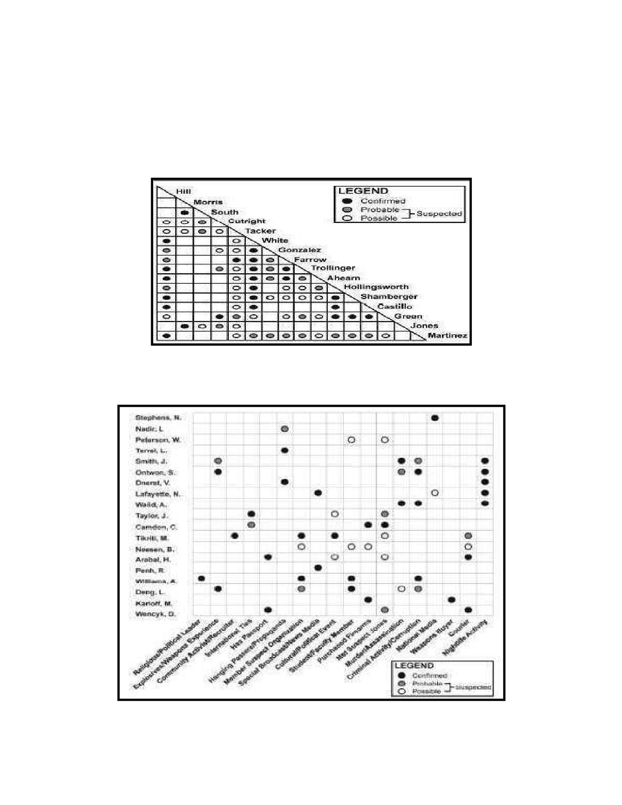
205
Figure 7-10, Association Matrix, portrays the existence of associations, known or suspected,
206
between individuals. Direct connections include such things as face-to-face meetings and
207
confirmed telephonic conversations. Association matrices identify those personalities and
208
associations needing a more in-depth analysis to determine the degree of relationship, contacts,
209
or knowledge between the individuals. The structure of the organization is identified as
210
connections between personalities.
211
212
Figure 7-10. Association Matrix
213
Figure 7-11, Activity Matrix, depicts linkages of people to activities they have been or are
214
involved in. Names are listed on the left and activities along the bottom.
215
216
Figure 7-11. Activities Matrix
7-9

217
Another useful product showing civil considerations is a depiction of availability of services to a
218
population. Figure 7-12, Health Care-Access, provides information on the Kandahar Province
219
Healthcare System. Provincial healthcare access is color-coded into five groups, illustrating the
220
percentage of the population that has access to health clinics. Using this product, commanders
221
and their civilian counterparts can ask the following questions:
222
What explains the discrepancies concerning access to healthcare?
223
What organizations and agencies can be leveraged to increase access to healthcare?
224
What would the second and third order effects be for increasing access to healthcare?
225
What HN, military, USG agency, and NGO assets can address access to health care?
226
This product can also be used to establish baseline metrics and assumptions for COA
227
development and establishing MOE. Though much more planning, research, collection, and
228
analysis are necessary to establish a civil baseline and provide answers to these questions, this
229
product is a good example of how an accurate visualization can enhance commander and civilian
230
decision maker planning processes.
231
232
Figure 7-12. Health Care-Access
233
Figure 7-13, Infrastructure-Wells and Clinics, provides another look at the same area but with a
234
broader perspective on infrastructure. Wells are labeled in green and clinics in orange. This
235
product can be used to form correlations between resources and facilities. It can be used to
236
develop future operations to conduct assessments about the capacity of Kandahar’s
237
infrastructure.
7-10

238
239
Figure 7-13. Infrastructure-Wells and Clinics
240
(3) Mitigation efforts products. Mitigation efforts are those activities that eliminate or reduce the
241
negative impact of events or conditions. CMO that address these events or conditions include
242
project management, which is a process requiring its own products. Some of these may be
243
appropriate to post to the COP, which includes projects of any unit in the OA. Products depicting
244
projects are built to show their effects relative to a destabilizing event or condition. Variables
245
that provide clarity about projects include:
Event or condition to mitigate
Capability gaps
Capability to accomplish-local,
Target population and effect of
national, and international resources
mitigation on them
CMO resources to fill gaps
246
Figure 7-14, Project Management Link Diagram, is an example of a product that depicts details
247
about 2 projects. It shows the POC for each project, major resources required for each job and
248
their status, and identifies the 2 required project tracking documents for each project.
249
NOTE: While Excel or other chart formats are commonly used to visualize project status such as
250
dollars spent, number of people employed, etc., link diagrams can also be a valuable tool for
251
presenting this information to decision makers.
7-11

252
253
Figure 7-14. Project Management Link Diagram
254
Step 3 - Quality Assurance and Quality Control. QA/QC is a systematic process to verify that the civil
255
information products satisfy the IR.
256
a. Ensure the product meets these requirements:
1. Content appropriate
2. Content accurate
3. Message clear
4. Audience appropriate
257
b. Verify that the product is properly classified. If over classified, coordinate with the original
258
classification authority (if available), security manager, FDO, or use established declassification
259
procedures, as explained in Chapter 8 to reduce the classification level.
260
WARNING: If the IR is not satisfied, make the necessary corrections, or return the data to its originator
261
for correction.
262
7.4 Best Practices
263
Whether selecting an existing product or developing a new one, submit the clearest possible answer to the
264
requirement based on the amount of time available. Perfect can be the enemy of good if it is late to the consumer
265
and no longer satisfies their requirement.
266
7.4.1 Answering RFIs
267
The format and standard for answering a civil IR is dictated by the information requested. The answer should be
268
based on facts. Any request that asks for conjecture or opinion should acknowledge that the answer is opinion
7-12
269
based on the available facts. A good technique for answering civil IRs is to not only state the facts, but display the
270
facts in graphs or charts that show their relevance.
271
7.4.2 Common Operating Picture Production
272
Maintain CMO Assessments, Area Studies, and Running Estimates. These products are resources from which to
273
populate the COP with the most current facts.
Select topics linked to LOOs
Define key drivers of conflict
Identify key nodes in the operating environment
Consider appropriateness of content for audience
Define the status of conflict mitigation efforts
274
7.4.3 Production as a Driver of Planning
275
Often in the joint-CIM process, multiple steps of the process can occur simultaneously and influence one another.
276
An example for this can be seen in Non Lethal Targeting. Here, a member of the J9 is a member of the targeting
277
board of a supported command. The board manages its own data using an information management process like
278
the CIM process. It shares products, derived from analysis, which were consolidated after they were collected.
279
Products the board produces inform planners of the types of operations that are needed to influence an outcome
280
in the civil environment. These outcomes can include not targeting some sites because of their cultural or religious
281
significance. J9s should always have a representative on these boards to influence future operations. The types of
282
product they routinely generate are:
1. Non-Kinetic Targeting Matrix
2. Protected Target List
3. PMESII Overlays
4. Collection Plan
283
7.5 Conclusion
284
The end state for production is products prepared for sharing with multiple audiences that accurately and
285
completely present the civil components of the operating environment, and enable the audience to visualize and
286
understand that environment. The information should be easily understood by the recipient without further
287
discussion.
288
7-13
1
2
3
4
5
6
7
8
9
10
11
12
13
14
15
INTENTIONALLY BLANK
16
17
18
19
20
1
CHAPTER 8 JOINT CIVIL INFORMATION SHARING
2
8.0 Introduction
3
Sharing is the sixth-step in the joint civil information management process, and is the delivery or exchange of
4
information between users in a usable form for application to appropriate missions, tasks, and functions. This
5
chapter provides guidance for sharing civil information between the JTF and non-DoD organizations to improve
6
operational synchronization, collaboration, and common understanding of the civil components of the operating
7
environment. Sharing occurs in three ways:
8
1. Push is the active dissemination of civil information to
“It’s not a technical issue any more. It’s
9
stakeholders with an explicit or implied requirement for it.
really more about culture and the need
10
2. Pull involves direct electronic access to databases, files, or
‘need to share’ rather than the ‘need to
know’.”
11
other repositories by military organizations at all levels1; and
General James Cartwright
12
providing stakeholders similar access to civil information.
USMC Commander, United States
13
3. Populate incorporates civil information to a civil COP,
Strategic Command
14
expressed as either the civil layer to a COP or a CMO COP, to
6 April 2005
15
support organizational requirements.
16
Sharing is a coordinating mechanism that promotes unity of effort between stakeholders by continually providing
17
relevant civil information they can use to further the objectives of their organization. Due to this, sharing serves as
18
a force multiplier for the supported unit, permitting the commander to reapportion resources from projects
19
already being executed by other stakeholder organizations and reassign them to other priority projects. Sharing
20
promotes unity of effort among the stakeholder community, reduces duplicative efforts, conserves unit resources,
21
and creates a spirit of cooperation and legitimacy to the various stakeholder boards, bureaus and working groups.
22
The following terms clarify concepts important to sharing:
23
Common Operational Picture: A display of relevant information shared by more than one command. The
24
COP is the standard reporting and display tool for the full spectrum of any US force engagement and at all
25
levels of exercises, operations, and war2
26
Data Owner: Data owners are the organizations, elements, or individuals responsible for managing
27
information on behalf of the supported unit, NGO, IGO, PVO, IPI, HN and so forth. Data owners control
28
and are responsible for the disposition and use of their information.
29
Figure 8-1, Share Civil Information, illustrates the three components (Push, Pull, and Populate) of sharing civil
30
information may be performed in any order, sequentially, or simultaneously, as needed to meet requirements.
31
NOTE: The term “information” generically refers to data, information, knowledge, and understanding.
8-1
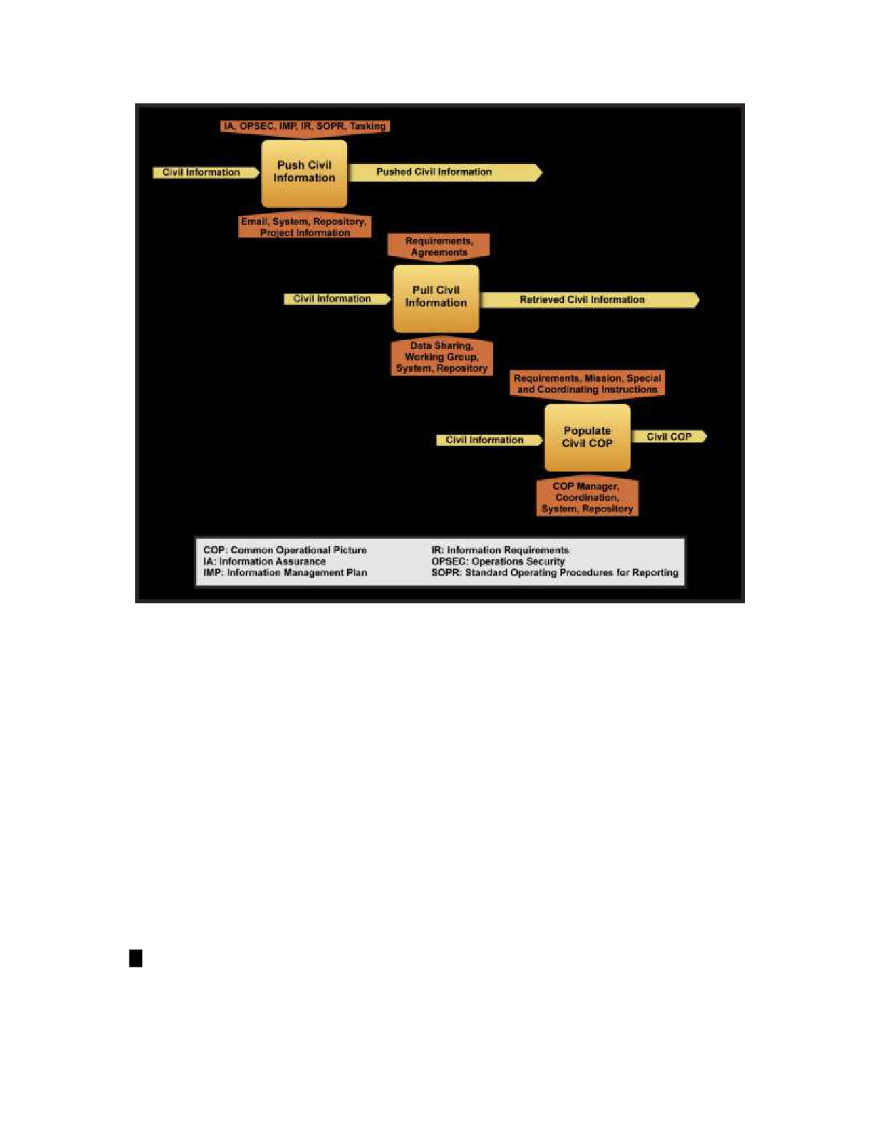
32
33
Figure 8-1. Share Civil Information
34
8.1 Context
35
Military forces routinely deploy into complex operating environments. Local, international and IGO may be
36
operating simultaneously on similar tasks. These partners bring capabilities not resident in military formations and
37
provide a distinct advantage in delivering those capabilities. Commanders that enable partner capabilities through
38
CMO create force multipliers, complement stakeholder efforts, and achieve their objectives sooner.
39
8.2 Push Civil Information and Reports
40
Pushing is actively disseminating information, facts, and data to users for a purpose. It involves identifying relevant
41
civil information to be disseminated and who should receive it based on specified or implied requirements. These
42
requirements are often identified during planning, or developed from changing operational requirements. Pushing
43
can take several forms, such as: interagency collaboration and data sharing or reporting relevant civil information.
44
A pushed knowledge product always satisfies a specific IR for a specific stakeholder identified during planning.
45
Pushing is accomplished through two distinct methods: push civil information; and report civil data. This section
46
describes considerations and practices applicable to both methods.
47
Push civil information is active dissemination data from the consolidation or production steps.
48
Information is pushed to support stakeholder requirements when they are authorized to receive it, and
49
requires continual coordination to maintain an awareness of stakeholder IRs, access, and connectivity.
8-2
50
NOTE: IRs change due to the dynamic nature of the civil environment. Staffs may not be capable of directly
51
fulfilling all IRs, but can effectively manage expectations by mediating between affected stakeholders.
52
Reporting is a recurring military requirement, and an output of the joint civil information management
53
process. It is where one echelon pushes civil information to their higher HQ, or other tasking authority.
54
Reported civil data has been collected, consolidated, analyzed, produced into a report, and pushed in
55
response to a recurring or one-time tasking. Reporting is a two-step procedure that involves transmission
56
of civil data to the tasking authority. Civil data reporting is not operational reporting (e.g. SITREP),
57
although they are normally complementary. Reporting procedure(s) executed are dependent on the
58
reporting organization capabilities. There are four methods for reporting:
59
o Verbally: In person, telephonic or radio transmission of data
60
o Hard Copy: Delivery of data in paper, CD/DVD, or removable media
61
o Email: Transmission of a digital data through an email client or system
62
o Automated Data Entry: Direct entry of data into the C4I infrastructure
63
8.2.1 Push Civil Information and Reports Considerations
64
To determine what civil information to push or report, the following questions should be asked:
65
1. What is identified in the collection plan as an IR?
66
2. What data does the reporting organization possess that is not specified as a reporting requirement in the
67
collection plan, but is relevant and should be reported?
68
3. What data does the reporting organization possess that is specified as a reporting requirement in the
69
collection plan? What are the stakeholder and supported staff IRs?
70
a. Perform gap analysis between the collection plan and supporting documents to known IRs and
71
information being shared to identify if the IRs are being met or the collection plan needs updating.
72
b. Use the gap analysis to build a new civil information baseline to facilitate the next planning step.
73
4. What is the importance, relative to existing operations and plans, of specific civil information? For
74
example, “Is this piece of information significant? Is it operationally relevant? Will it make a difference?”
75
5. Are any tasks or IRs time sensitive? Is there a civil information latest time of value (LTOV) requirement?
76
6. What are the requirements for periodic updates from staff and stakeholders on the current status of
77
consolidated civil information?
78
7. What are the supported units or stakeholder “Battle Rhythms”?
79
8. What information requires authorization from the FDO for release?
80
Information will be released IAW DoD3, service, and command policies.
81
WARNING: The supported command or other unit may not have an FDO on the staff. In this circumstance a FDO
82
may be located at a higher level command, which will require more time to process the disclosure authorization.
83
CAUTION: Placing unclassified civil data onto SIPRNET immediately decreases its availability to audiences
84
outside of the supported command, and greatly complicates copying the data to unclassified networks.
85
The primary method to internally share information is to report. For elements and units to report civil data the first
86
consideration is the report model. Current reporting models (i.e. size, activity, location, unit, time, equipment
87
(SALUTE), size, activity, location, time (SALT), 9-line reports, operation summary (OPSUM), etc) do not adequately
88
support population-centric operations because they do not include the civil components of the operating
89
environment. Therefore, the first and primary consideration is the establishment of an AO or unit SOP for
8-3