Military reference books and manuals (2009-2023, Volume 3) - page 28
NATO-UNCLASSIFIED
ATP-17(C)
c. The groin region.
2. The hands and feet have a blood supply which quickly constricts in the cold. Constricting
boots/socks and gloves decrease the blood supply, increasing the risk of frostbite. Accordingly:
a. Dress warmly using the layering principle.
b. Clothes should be slightly loose-fitting.
c. Toes should be free to move in boots.
d. Protective coatings can help prevent drying/cracking of lips.
3. When standing watch in the cold, improve circulation to the feet by periodically bouncing on the
toes. This will increase heat to the feet, making frostbite less likely. The fingers and hands may also
be exercised to keep them warm.
4. Eating/Drinking
a. Bodies are like engines and require fuel to burn in order to make heat. Accordingly, it is
essential that an adequate diet be provided each day so that the body can produce heat to help
withstand the extreme cold. An increased relative percentage of fats and proteins are
recommended due to their heat-producing potential. Besides having nutritional value, food can act
to re-warm the core - in the form of hot chocolate, soup, etc.
b. In addition to food, the body requires a good deal of water daily to carry on normal functions.
It is advisable to drink at least two litres of water per day to avoid dehydration. Melted ice and
snow may be substituted if other fluids are unavailable. The consumption of ice and snow in the
solid state may increase the risk of hypothermia, particularly if there are inadequate food supplies.
914 DEHYDRATION
1. Everyone has experienced dehydration on a warm summer day, but in the cold it's a different
matter. Not only is it less easily recognized, but the effects of dehydration may be devastating.
Normally the body controls its fluid balance by filtering off excess water and drinking (due to thirst) to
replace lost water. In the cold, both of these mechanisms are disrupted:
a. In extreme cold, personnel do not become thirsty as dehydration sets in.
b. Also in extreme cold, urination increases.
2. These factors, coupled with excessive caffeine intake, cause increased urination, and can lead to
dangerous dehydration. The water present in the blood (which makes up a significant portion) helps
carry warmth to the body, so the dehydrated individual is at even greater risk for the injuries
discussed. Avoid dehydration, be on the look-out! Early signs include low pulse rate, constipation,
and dark urine (in reduced amounts). Be sure to drink extra amounts of water every day.
9-9(Reverse Blank)
ORIGINAL
NATO-UNCLASSIFIED
INTENTIONALLY BLANK
NATO-UNCLASSIFIED
ATP-17(C)
CHAPTER 10
GENERAL OPERATIONS
1001 ICE-BREAKERS
1. Broadly speaking there are three categories of ice-breakers:
a. Harbour;
b. Non-Polar; and
c. Polar.
2. Type a. covers small ice-breaking vessels, generally not much larger than tugs, engaged in
keeping rivers and small harbours clear of thin ice. Type b. embraces large ice-breakers employed in
keeping areas of sea clear of ice, freeing ships trapped in areas such as the Baltic and the Gulf of St.
Lawrence. Type c. covers ice-breakers capable of operating in very heavy and hard Arctic ice. In
addition, ships of this last type usually support oceanographic, hydrographic and other related
scientific activities in the Polar regions. The remarks which follow apply, in the main, to Polar ice-
breakers.
3. Should an ice-breaker become stuck in the ice, heeling and trimming tanks are provided, together
with large-capacity transfer pumps. Sea-water, or fuel, can be transferred from one side to the other in
large quantities and very quickly - 275 tons in 90 seconds is an example of a typical system. Similarly,
liquid can be moved from a forward trimming tank to an after one, or vice versa. These activities,
when used in conjunction with the ship's engines, are usually sufficient to start the ship moving.
Smaller ice-breakers lacking a heeling system, and fitted with a centre line crane, can rock the ship by
swinging a heavy weight from side to side.
4. Draft should be sufficient to accommodate large propellers whose tips, when in the upper position,
will be at least 2 metres below the surface of the water.
5. There are five factors which govern the ability of a Polar ice-breaker to do the job she was
designed to do, and do it effectively. These are:
a. The power, displacement, and strength of the ship.
b. The nature and extent of the ice being attacked.
c. The shape of the hull, particularly the bow form.
d. The capability of rapid heeling and trimming.
e. The skill, experience, and intelligence of the ship handler.
1002 SHIPS
As a general rule, a full-powered ice-strengthened ship should be able to make relatively good
progress through 6/10 winter ice. A careful assessment should be made of every aspect of wind and
current in relation to ice drift when a ship is moving alone through waters where pack-ice extends over
large areas. Every effort should be made to avoid being caught between an extensive area of pack-ice
10-1
ORIGINAL
NATO-UNCLASSIFIED
NATO-UNCLASSIFIED
ATP-17(C)
and the shore, or between the pack and a danger such as a shoaling area, when the wind is blowing
strongly onshore.
1003 AIR-CUSHION VEHICLES
1. Air-cushion vehicles have an ability to operate over Arctic terrain, and possess certain advantages.
a. In case of engine failure, air-cushion vehicles are safer than a light aircraft or helicopters.
b. The reservoir of air holding the craft up leaks away comparatively slowly enabling the vehicle
to settle on the surface.
c. Air-cushion vehicles can float on water.
d. Emergency stops can be made on snow from speeds of 26 knots without suffering damage.
2. Air-cushion vehicles are capable of traversing a wide variety of terrain at speeds up to 60 knots or
more. In addition to travelling over water, land and ice, air-cushion vehicles can negotiate muskeg,
soft snow and mixtures of thin ice and open water with equal facility. By their nature they are best
suited to lands of gentle relief and flat non-ridged ice. Present designs can pass over irregularities
(rocks, ridges of ice, etc.) up to 120 cm high.
3. Operation over water at temperatures below the freezing point can lead to spray freezing onto the
craft and loading it down with ice.
1004 DIVING
1. Diving Conditions. Arctic waters are cold, the visibility excellent, and the bottom generally flat.
Shifting ice, driven by wind and current, is the greatest danger to divers. Most diving work is carried
out in shallow water, clearing beach obstructions and surveying approaches to landing sites.
2. Equipment. A wet suit with compressed-air breathing apparatus, both of which are easily
transported and self-sufficient, are suited to diving requirements in the Arctic. An air compressor is
necessary for charging bottles and an inflatable rubber boat or raft, equipped with a small outboard
motor, is handy and safe for transporting divers and their equipment.
3. Explosives. Explosives used in demolition of ice and rocks must have very high shattering
properties. Ice is extremely hard to dispose of due to its density, and large charges are often necessary.
A 60/40 ratio of Forcite and Nitrone has proved to be effective.
4. Ship Repair. Underwater cutting and welding equipment should be carried to facilitate fixing
ship's plating, rivets, propellers, and rudders.
ORIGINAL
10-2
NATO-UNCLASSIFIED
NATO-UNCLASSIFIED
ATP-17(C)
CHAPTER 11
SHIP HANDLING IN ICE AND ICE SEAMANSHIP
1101 INTRODUCTION
1. The first principle of ice seamanship is to maintain freedom of manoeuvre in the presence of ice.
2. Three thoughts should be uppermost in the mind of a commanding officer whose ship is working
in ice:
a. Keep the ship moving-even slowly.
b. Try to work with, not against, the ice.
c. Be patient. The longest way round can often be the quickest, safest way home. Ice is no
respecter of schedules.
1102 NON-ICE-STRENGTHENED SHIPS
Ice is an obstacle to any ship, even an icebreaker, and it is dangerous to those ships which, by their
construction, were never really intended for ice navigation. Nevertheless, it is possible for non-ice
strengthened ships to navigate through regions of open pack-ice. The long hours of summer daylight in
high latitudes facilitate such operations.
1103 INDICATIONS OF ICE
1. Iceblink, which is the reflection of ice on low cloud, is an indicator much used by experienced
navigators. It appears as a diffuse whitish glare above an accumulation of distant ice and is especially
noticeable when observed on the horizon.
2. Isolated fragments of floating ice often presage the approach of larger quantities of ice or warn of
the presence of icebergs nearby.
3. In late spring, and during the Arctic summer, there is frequently a thick bank of fog over the edge
of the pack-ice. In fog, patches of whiteness can indicate the presence of ice at short range.
4. Absence of sea or swell, especially in a fresh breeze, can be a reliable sign of ice to windward.
5. A drop in temperature of the surface of the sea, or a drop in the air temperature, can indicate that a
ship has entered waters where ice is likely to be encountered.
6. When clear of land, the sighting of seals, walruses or birds can be a sign of approaching ice.
1104 SIGNS OF OPEN WATER
1. Dark patches on low clouds, sometimes almost black in comparison with the general overcast, can
indicate open water, and is known as "water sky".
2. In fog, dark areas discerned through the murk can give an indication of open water.
11-1
ORIGINAL
NATO-UNCLASSIFIED
NATO-UNCLASSIFIED
ATP-17(C)
3. A dark band of cloud at high altitude can indicate the presence of a lead giving access to open
water further away.
4. A surging action in the pack-ice can indicate the presence of open water nearby.
5. If, when approaching ice, there is darkness on the horizon beyond a light sky, this is good evidence
of open water or land lying beyond the ice, in some cases 40 nautical miles (75 km) or more beyond
the visible horizon. If dark streaks are observed in the sky, the presence of leads is indicated. If there
are no dark streaks, a ship should steer for the place where the iceblink is dullest. Iceblink is increased
after a fresh fall of snow, since its reflection in the sky will be whiter from this snow than from the ice.
6. In a cloudless sky and calm weather, abnormal refraction may raise the horizon enabling an
observer to see ice at greater distances than normally would be possible. The image of ice or areas of
open water, or a mixture of the two, may be seen as an erect or inverted image, or both images may be
seen at once, one above the other. In this latter case the erect image is the higher of the two. Refraction
also causes bergy bits to appear like icebergs. Where there is open water, a dark-blue color will be
seen towards which the ship should steer.
1105 ICEBERGS
1. On dark clear nights, icebergs may be sighted at a distance of 2000 to 4000 yards, appearing either
as white or black objects. In such conditions bergy bits or growlers constitute a greater hazard to ships.
Such pieces of ice may also be difficult to distinguish in daylight, especially in a rough sea.
2. A clouded sky at night, through which the moon appears and disappears, makes ice detection
difficult. Heavy passing clouds may dim or completely obscure an object sighted ahead. Fleecy
cumulus and cumulo-nimbus clouds often give the appearance of blink from bergs.
3. Radar can usually detect large icebergs in ample time to avoid collision, but small bergs and
growlers, capable of causing damage even to ice-strengthened ships, may remain undetected under
quite moderate conditions of wind and sea. As the state of a sea increases, so does the minimum size
of the iceberg that can be detected.
4. Air and sea temperatures are not a reliable warning of the presence of icebergs.
5. In low visibility the use of a foghorn or siren to detect icebergs by echo is of little use. Sound
waves will be reflected only by a high vertical wall of ice, and even then are rarely audible.
6. The presence of stationary icebergs may give some indication of the depth of water in their
vicinity. For example:
a. An accumulation of stationary icebergs often marks an isolated shoal.
b. A line of grounded icebergs extending seaward from the shoreline, or between an island and
the mainland, may indicate the presence of a submerged ridge or shoal.
c. A shoreline fringed by glaciers, or studded with icebergs inshore but free of ice to seaward,
would indicate that the shoreline falls off steeply into deep water.
d. A bay in which icebergs are found must have a deep channel leading into it. The sides of a
channel which are bordered with icebergs, but with its centre clear, may be considered safe. Open
ORIGINAL
11-2
NATO-UNCLASSIFIED
NATO-UNCLASSIFIED
ATP-17(C)
water will usually be found during the summer months along a coast where offshore winds
prevail.
1106 ENTERING THE ICE
1. Before committing a ship to the ice-pack, a complete reconnaissance of the area should be
undertaken, using every means available-radar, look-outs, helicopter observations, and ice reports
from long-range fixed-wing aircraft. The point of entry should be carefully selected and the ice entered
at right angles, after which the ship should make for the loosest areas in the pack. Preferably make the
entry upwind, remembering that the windward edge of an ice-field will be more compact than its
leeward edge. The violent motion of ice from the action of the waves will also be damped out on its
leeward side.
2. Avoid a lee shore on which ice is usually dense and hummocky. Favour a windward shore where
an open channel may be found. Do not manoeuvre so closely to points of land that a combination of
wind, ice, and unknown currents could force the ship aground.
3. If the ice is drifting rapidly, wait (preferably in open water) for a change in direction of the ice
movement, taking into account the times of ebb and flood tide; ice tends to compact on the flood and
to loosen up on the ebb.
4. An ice edge is usually not straight but often has tongues projecting between bights. Select a
suitable bight and enter there where the surging action will be least.
5. Enter at slow speed to reduce the initial impact on the stem. Once the bow is in the ice, cutting and
pushing it aside, power should be increased to avoid losing headway.
6. Give all icebergs and other forms of glacial ice in the pack a wide berth. If a collision with a floe is
inevitable, it is best to take the blow on the stem while going astern at full speed.
7. Navigation in pack-ice after dark, or in fog, or when the ice is under pressure, should not be
attempted.
8. Propellers are the most vulnerable part of a ship, and conning officers must see to it that whenever
heavy ice approaches the stern, action is taken to slow the shaft.
9. If the bow of a ship rebounds off a floe, the stern may be swung into heavy ice with a risk of
damage to rudder and propellers.
1107 SPEED OF SHIPS WORKING IN ICE
1. Speed through ice must be a matter of judgment and will depend, among other things, upon the
amount of open water, the hardness of the ice, and the strength of the ship.
2. Coasting into ice, with engines stopped, will probably result in loss of steerage-way.
3. At any time ships should be prepared to go "Full Astern".
4. In less than 6/10 ice, the speed of a ship passing through the ice, without ice-breaker escort, should
depend on the distribution of leads and pools of water.
11-3
ORIGINAL
NATO-UNCLASSIFIED
NATO-UNCLASSIFIED
ATP-17(C)
5. Seven to nine-tenth ice should be negotiated throughout at slow speed, so that collision with floes
will not damage the hull.
6. When moving through very loose pack at night, or in poor visibility, continue with caution and at
slow speed. In such circumstances, searchlights, preferably mounted in the eyes of the ship, can be of
considerable help.
1108 WORKING THROUGH ICE
1. The extent of the ice should be studied from aloft, preferably from a helicopter. In this way distant
leads and open water, invisible from the bridge, may be revealed. The character of the ice ahead, when
viewed from aloft, may sometimes be assessed by comparing it with the ice through which the ship
has just passed. Pressure ridges and ice which is greenish-blue in color (polar ice) should be avoided.
2. Sometimes pools of melt-water form on top of the ice. From the air, and even from a distance at
sea level, these pools can resemble open pack. Upon closer examination it will be found that the ice is
continuous under the pools and may even be unnavigable.
3. Aerial ice observers should be thoroughly trained and familiar with the problems confronting the
ships to which they are passing important information. To provide continuity, the same ice observers
ought to be used, and such observers must have the confidence of the captains, who may have to rely
heavily upon their reports.
4. A short burst of full speed ahead, with the helm over, may be of assistance in speeding up a turn to
avoid a floe. Propellers and rudder may be afforded some protection by trimming by the stern.
5. Ships should go astern in ice with extreme care, always with their rudders amidships, and while
keeping a sharp outlook for ice under the quarter. One system for working astern in ice is to:
a. Allow propellers to wash the ice astern for a few minutes before going astern.
b. Go full astern until just before contact with the ice debris, then stop and allow the momentum
to carry the ship into the churned-up ice.
c. When all ice has surfaced, give a short burst of ahead power and stop.
d. Repeat this process until sufficient manoeuvring room has been produced.
6. Another effective system for working a twin-screw ship astern, when surrounded by heavy brash,
is to:
a. Go astern on one engine while going ahead on the other, setting up a current under the stern
which opens up an area of clear water to one side depending upon the engine direction.
b. Go astern on both engines. This should move the stern into the open area until the ice
eventually brings the ship to a halt.
c. When stopped, repeat backing on one engine and going ahead on the other, but in the
combination opposite to that used previously, until an open area of water appears on the other
side.
ORIGINAL
11-4
NATO-UNCLASSIFIED
NATO-UNCLASSIFIED
ATP-17(C)
d. As in b. above.
7. Cracks may form in ice-fields along a line of pressure perpendicular to the movement of the ice.
Such cracks are sometimes ridged. At the least change in wind or current, these heavy masses may
come together crushing and grinding anything caught between them.
8. Fine weather in the pack often portends lower temperatures, close pack and little open water,
whereas damp and misty weather generally signifies the presence of some open water and better
conditions for manoeuvring. The presence of swell indicates loose pack is near at hand and open water
not very far off.
9. Any offshore wind usually creates a channel between the coast and the pack. If this is exploited by
a ship, she should be alert for an onshore wind driving the pack onto the coast if the latter is steep-to.
In such a case, shelter should be sought in a bay or behind an island. Failing any such refuge, the only
alternative would be to go out and meet the ice hoping to work through it to open water.
10. Icebergs generally move at a different rate than the sea ice and in strong currents may even travel
upwind. In these conditions, open water will exist to leeward, and piled-up pressure ice to windward
of icebergs. In a strong wind the pack may overtake the icebergs, resulting in a heaping up of the pack
to windward, while a lane of open water opens to leeward of the icebergs. This creates the illusion that
the icebergs are travelling in a direction opposite to the pack.
11. The movement of an iceberg through wind-compacted ice creates a lead which may remain open
for a time. In traversing pack, advantage might be taken of such leads.
12. If a ship enters a narrow strait or bay into which the prevailing winds are known to blow, she
should be alert to the possibility of ice being driven in by a sudden change in weather and trapping her
there.
13. A ship should exercise caution when to windward of a prominent headland because a sudden
increase in the wind may drive the pack down upon the vessel which, if set toward a lee shore, may
become beset and subject to pressure. An exception to this occurs in the western Canadian Arctic and
along the north Alaskan coast where ships successfully navigate close inshore, depending upon their
draught, thus avoiding the heavy pack lying to seaward.
1109 CONVOYING IN ICE
1. An ice convoy consists of one or more ships, some of which may be strengthened for ice
navigation, accompanied by one or more ice-breakers.
2. It is essential that such a convoy, while in ice, be under the direction of the commanding officer of
the leading ice-breaker. Should the senior officer of a naval force happen to be embarked in a ship
without ice-breaking capabilities, he must delegate tactical control to the senior ice-breaker captain.
1110 TYPES OF CONVOY
1. There are two types of ice convoy:
a. Simple convoy: one ice-breaker escorting a group of ships.
b. Composite convoy: two or more ice-breakers escorting several ships.
11-5
ORIGINAL
NATO-UNCLASSIFIED
NATO-UNCLASSIFIED
ATP-17(C)
2. For a simple convoy, the captain of the icebreaker will decide upon the number of ships he can
handle. His decision will depend not only on the number, but on the power and type of ship requiring
escort and the ice conditions expected en route. If the ships are reinforced for ice navigation, and have
sufficiently powerful engines, one ice-breaker can usually escort four of them through 7/10 to 9/10 ice.
In 5/10 or 6/10 ice or less, the number of ships can be increased. If there is close pack (more than
9/10) only one or two ships can be handled.
3. The first factor to be considered must be the power of the ships requiring escort. The weakest, as a
rule, should be stationed immediately astern of the ice-breaker to avoid ice obstacles and to move in a
comparatively clear channel. The most powerful ships with wide beams should be interspersed in the
convoy so that less powerful ships can proceed in their wake. Consideration should also be given to
whether a ship is loaded or in ballast. Finally, it is essential that one of the most powerful ships in the
convoy be last in line.
4. A composite convoy consists of two or three simple convoys. The number of ships allocated to
each ice-breaker, and their place in the column, is determined in the same way as for a simple convoy.
The difficulty of controlling from a position ahead is a drawback in this type of convoy, which
frequently extends over a distance of 2 NM (3.7 km) or more.
5. The customary procedure is for the most powerful ice-breaker to lead the convoy, breaking a
channel in the ice without stopping to break out other ships. Following the leader, at a distance
decided upon by the captain, come two or three ships, the weakest and longest in the convoy. The
second ice-breaker proceeds astern of the first group followed by two or three ships, and so on.
6. The assignment of the second ice-breaker is to break out the ships ahead so the leader will not have
to return, thus delaying the whole party. The second ice-breaker, on receiving a "stuck" signal from
any of the preceding ships, increases speed, leaves the column and breaks out that ship. When the
latter is freed and moving, the ice-breaker resumes previous position in the column. Similar action is
taken by the second ice-breaker upon receiving a signal from one of the ships astern, provided there
are no more ice-breakers available.
1111 DISTANCE BETWEEN SHIPS
1. Before entering the ice, the captains of all ships should set the agreed distance between their ships
and the ice breakers, and between other ships.
2. It is unwise to have the convoy strung out in too long a line. At the same time, the distance
between ships should be great enough for way to be checked and collision averted if a "stop" signal is
originated by any one of the ice-breakers. At ice convoy speed, way in merchant ships of average
tonnage can be checked in ice-free waters by going astern over a distance of three to three and a half
ship lengths, provided an order for full speed astern is given. This distance should, therefore, be the
minimum between ships when navigating in less than 7/10 ice.
3. Depending upon ice conditions, very large ships (i.e., those displacing 100 000 tons or more) must
keep farther apart. Until more experience is gained in convoying ships of this size through ice, at least
1000 yards is recommended as a minimum.
4. A channel made by an ice-breaker will eventually fill with broken ice. The speed at which the
channel closes will depend on the amount of ice pressure encountered. This will have a factor in
determining the distance between the ships. The difficulties caused by this to a ship in a narrow
channel increase when the distance between ships is increased, and even powerful ships may find their
speed greatly reduced. This makes it all the more important for ships to maintain the minimum
ORIGINAL
11-6
NATO-UNCLASSIFIED
NATO-UNCLASSIFIED
ATP-17(C)
prescribed distance apart. Signals from the leading ice-breaker must be obeyed promptly and correctly
and all ships must be alert for any difficulties and delays caused by ice.
1112 COURSE AND SPEED OF CONVOY
1. The longest safe route in open water will generally be quicker than a more direct one in ice, and
the selected track should pass through areas of thin ice or open water, regardless of the length of the
voyage. Course changes should be gradual since most cases of ships getting stuck occur when sharp
turns are made by the much more manoeuvrable ice-breaker. Speed over the ground through the pack
usually varies between 4 and 7 knots. The higher speed is desirable due to better manoeuvrability of
large ships, but ice conditions must be the governing factor.
2. In a convoy composed of ships reinforced for ice navigation, a speed over the ground of 6-7 knots
can be maintained if the route lies through 5/10 open pack, and if the ships following the icebreaker
will not meet with heavy ice.
3. If a single-screw ship must suddenly go full astern without warning while passing through an ice-
covered channel, the stern will kick to port and the bow to starboard. This could damage the propeller,
rudder and starboard side of the ship. To avoid collision with a ship ahead, it is preferable to ram the
ice on one side of the channel, bow foremost, rather than risk damage to the rudder and propeller by
going astern in heavy ice.
4. When navigating in close pack (7/10 to 9/10), speed over the ground should not exceed 5 knots. In
such ice a convoy will be moving in a channel which will not remain navigable for very long after the
passage of the ice-breaker. Therefore, the distance between ships must be reduced to enable them to
move in as clear a channel as possible. Higher speeds not only increase the danger of hitting the ice,
but also the possibility of colliding during unscheduled stops of the icebreaker or other ships of the
convoy.
1113 CONDUCTING THROUGH ICE
1. When following an ice-breaker, a convoy should keep in line. By looking for independent
channels, ships break up formation and may become stuck.
2. Since headway through heavy floes and ice-fields is more difficult than through "normal" pack, an
ice-breaker increases speed and, by striking the ice, crushes or breaks it. Ships astern must maintain
correct intervals and endeavour to enter the channel thus made before it closes.
3. If an ice-breaker should encounter an obstacle where a glancing blow is struck by her stem, she
will be thrown sideways. Ships following behind may be too unwieldy, or be unable to react quickly
enough, and may suffer damage. This is particularly applicable to singlescrew ships. This sudden
change of direction should be expected when moving through ice of varying structures and strength. In
such circumstances an icebreaker should not make too rapid a return to her original course.
4. In summer there are many signs indicating the state of the ice. Careful observations should be to
determine whether the ice has been softened by the sun or if it still retains its winter hardness.
Greenish or greenish-blue ice is the hardest to break and such ice should be outflanked. This type of
ice is sometimes covered with pools of clear melt-water formed during the thaw of snow on the
surface of the ice. If sections of dirty-looking ice are encountered in areas of light-colored ice, the
former should provide the easier route, since the darker ice absorbs more heat from the sun and melts
sooner.
11-7
ORIGINAL
NATO-UNCLASSIFIED
NATO-UNCLASSIFIED
ATP-17(C)
5. The most navigable type of ice is brash, even though it may be devoid of leads. Although this ice
usually closes up as a result of tide and wind, it consists of separate cakes and does not present a
serious obstacle. When the pressure is great, however, even though an ice-breaker can get through, a
ship astern may be hindered as the channel behind the ice-breaker closes up immediately. In brash,
even under pressure, ships are in less danger than if they were being pressed by larger and heavier
forms of ice.
6. When hummocked ice is met, an ice-breaker should first attempt to outflank it. The outward
characteristics of hummocky ice may indicate to what extent it will be navigable. If the hummocks
consist of loose blocks not fused together into one solid piece, they may easily be overcome, but if
they are composed of larger masses of ice many feet thick, they will be impassable even to an ice-
breaker.
7. Usually an ice-breaker backs up one to three ship lengths, then goes full ahead until the stem
attacks the ice. If ice is strong and extends over a great area, this process must be repeated and
progress will be very slow.
8. It may be necessary to make either a simple channel, equal to the beam of the ice-breaker, or a
double or triple one, depending on the strength and character of the ice and on the size of the ships
waiting to get through.
9. While navigating in heavy ice, ships should be so loaded and trimmed that only the water-line
plating will be in contact with ice. In the after part, the propeller is exposed to danger. It is often
assumed that blades are damaged only when a ship is going astern. Blades can be damaged or lost
while going ahead as well. Sometimes large blocks of ice pass under the ship's hull and turn on edge.
Such ice is dangerous and can damage propellers.
1114 SIGNALLING BETWEEN ICE-BREAKERS AND ESCORTED SHIPS
1. Suitable signals which have been adopted for use are given in Chapter 13 of the revised (1969)
International Code of Signals and may be used between icebreakers and ships navigating in their
vicinity or under their escort.
2. The signal "K" (-.-) by sound or light may be used by an ice-breaker to remind ships of their
obligation to listen continuously on their radios.
3. The use of the special signals from the International Code of Signals (1969) does not relieve any
ship from complying with the International Regulations for Preventing Collisions at Sea.
4. Whistle signals are limited in their value. Experience has shown them to be of questionable value
in a convoy of several ships because of the time lag and the danger of misinterpretation. Whenever
possible, voice radio should be used and, when ships are close aboard, loud hailers can be used very
effectively.
1115 STOPPED ICE-BREAKER - RED WARNING LIGHTS AND SOUND SIGNAL
1. Canadian ice-breakers escorting ships in ice make use of two special rotating red warning lights to
indicate that ice-breakers are fouled or jammed in ice.
ORIGINAL
11-8
NATO-UNCLASSIFIED
NATO-UNCLASSIFIED
ATP-17(C)
2. These two red lights are disposed in a vertical line, one over the other about 2 metres apart and
they are visible all around the horizon at a distance of 2 NM (3.7 km). They rotate in a manner similar
to-the lights on air beacons and are unmistakable as warning lights.
3. The rotating red lights operate in conjunction with a motor-driven siren, facing astern, audible up
to a distance of about 5 NM (9 km) depending upon atmospheric conditions.
1116 BREAKING OUT SHIPS
1. When a ship is beset, awaiting ice-breaker assistance to get moving again, it should keep
propeller(s) turning slowly to keep the ice away. If engines are stopped, ice will move in around the
stern making it dangerous to start turning the propeller(s).
2. Ice-breakers usually prefer to drop back stern first from ahead until abeam of the stuck ship. They
then move ahead, instructing the latter to follow. The open water left by the ice-breaker should be
immediately occupied by the beset ship.
3. Most ice-breakers dislike coming up from astern of a beset ship for fear of shoving ice under the
latter's stern, and possibly jamming rudder and propeller(s). Ice-breakers should be careful not to push
heavy floes against the sides of thin-skinned ships, which could rupture their plating.
4. There are many ways in which an ice -breaker can free a beset ship and no attempt is made to
cover them all here. Ice conditions have a bearing on the tactics to be used. Ice-breaker captains will
always communicate their plan to the ship to be helped.
1117 REPLENISHMENT IN ICE
1. Replenishment in ice can be accomplished only when both ships are stopped and lying as close
aboard each other as practicable. Prevailing ice conditions should be carefully studied to ensure that
replenishment can be completed safely. Pack that is drifting into a lee shore must obviously be
avoided.
2. When approaching another ship in the pack there is a danger that the pressure generated by the
approaching ship will force intervening ice blocks through the plating of one or both ships, or will
damage rudders and propellers of the ship approached.
3. A bow-to-bow approach is generally safest for berthing alongside another ship. If an ice-breaker is
available, it should proceed carefully through the ice ahead of the ship making the approach.
1118 ANCHORING
1. Anchoring in the presence of ice is risky. The minimum amount of cable should be paid out and
the capstan must be available for immediate use in the event heavy pack-ice approaches the anchorage.
2. When anchoring in rotten ice or in shallow water, a ship should first attempt to penetrate the ice as
far as necessary to avoid any swell. If the water is deep and ice is present, anchoring should be
avoided. In such circumstances it is preferable to heave to, keep power available and manoeuvre as
necessary to avoid floes which may approach and threaten the ship.
11-9 (Reverse Blank)
ORIGINAL
NATO-UNCLASSIFIED
INTENTIONALLY BLANK
NATO-UNCLASSIFIED
ATP-17(C)
CHAPTER 12
ARCTIC NAVIGATION, NAVIGATIONAL AIDS
AND PILOTAGE
1201 GENERAL
With satellite navigation systems
(i.e. GPS) being fully operational, navigation in the Arctic is
achievable by all properly equipped platforms.
1202 HARTS AND SAILING DIRECTIONS
1. Requirements for charts and related publications can be met from the following sources:
a. Catalog of Maps, Charts and Related Products, published by the Defense Mapping Agency,
Washington, DC, 20315-0010.
b. Catalogue of Nautical Charts and Publications, published by the Canadian Hydrographic
Service, are available from the Hydrographic Chart Distribution Office, Department of Fisheries
and Oceans, 1675 Russell Road, PO Box 8080, Ottawa, Ontario Canada K1G 3H6. Telephone
(613)998-4931. FAX (613)998-1217. (VISA and Mastercard accepted).
c. Catalogue of Admiralty Charts and Other Hydrographic Publications, published by the
Hydrographer of the Navy, Tauton, England.
2. American and British authorities also publish classified catalogues describing selected classified
charts and publications embracing Arctic areas.
1203 GENERAL REFERENCE BOOKS
A number of Arctic navigational reference books are available. The Arctic navigator must procure all
necessary references prior to sailing for northern waters.
1204 CHART PROJECTIONS
1. The Mercator projection satisfies the navigator's needs to the 70th parallel of north latitude. In
latitudes higher than 70°N, however, the usefulness of the Mercator projection decreases rapidly,
primarily because the value of the rhumb line becomes progressively less, and because there is an
increasing rate of change in chart scales.
2. Chart producers generally opt for a more appropriate projection for Arctic use. The four most
commonly used are:
a. Transverse Mercator Projection -particularly when considering areas extending north-south.
b. Modified Lambert Conformal Projection.
c. Polar Stereographic Projection.
d. Polyconic Projection.
12-1
ORIGINAL
NATO-UNCLASSIFIED

NATO-UNCLASSIFIED
ATP-17(C)
1205 POLAR GRID
Because of increasing convergence of the meridians near the pole, the true directions of an oblique
course line will vary considerably depending upon the length of the course line and its proximity to the
pole. A polar grid provides the navigator with the changing true direction. The polar grid is described
in the H.O. Publication No. 9, Chapter XXV-Polar Navigation, and shown in Figure 12-1.
Figure 12-1 Polar Grid Navigation
ORIGINAL
12-2
NATO-UNCLASSIFIED
NATO-UNCLASSIFIED
ATP-17(C)
1206 MAGNETIC COMPASSES
1. The directive force of the magnetic compass is derived from the horizontal component of the
earth's magnetic field. Although the total intensity of the earth's field remains fairly constant in all
latitudes, the horizontal component decreases as the magnetic poles are approached, until the directive
force becomes so weak that the compass is apparently insensitive and unresponsive.
2. Conversely, the vertical component increases and may give rise to large heeling errors. Although
the horizontal component of the earth's fields and hence the induced magnetism in horizontal soft
iron, decreases as the magnetic poles are approached, the field of sub-permanent magnetism of the
ship's structure retains its absolute value and therefore becomes relatively much more important in
causing deviation. Small uncompensated deviations due to sub-permanent magnetism may attain very
large values in high latitudes.
3. Furthermore, magnetic disturbances or magnetic storms cause fluctuations in magnetic variations.
For example, a severe magnetic disturbance can shift the effective position of the magnetic pole as
much as 150 km or more. This shift has significant effects near the magnetic pole, becoming less of a
problem with distance from the magnetic pole.
4. To obtain the best performance from the magnetic compass in Arctic waters, a ship should be
swung and the compasses adjusted in high latitudes, preferably before entering the pack-ice. If the
Flinders bar has not been permanently set at the magnetic equator, it must now be adjusted to the
position indicated by computation, and the horizontal and heeling magnets carefully placed to produce
minimum deviation. The US Defence Mapping Agency publication NVPUB226, "Handbook of
Magnetic Compass Adjustment" is a useful reference. AVPUB9V1, "American Practical Navigator",
also applies.
5. Even if this recommended procedure is followed, changes in magnetic latitude may cause large
deviations to reappear. Likewise the magnetic variations will change rapidly with locality and may
undergo large diurnal changes, particularly if auroral activity is present, so that the navigator must
undertake frequent azimuth determinations. If large compass errors are found, and if it is uncertain
whether these are due to variation or deviation, swinging the ship again to see whether the error
persists on all headings will establish the cause.
6. Provided that precautions have been taken (e.g., burning the binnacle light continuously and
keeping the binnacle itself covered by canvas when not in use), the liquid in modern magnetic
compasses is capable of withstanding Arctic temperatures.
7. The flux-gate compass has proved to be quite sensitive and has given fairly accurate and reliable
results. The Admiralty gyro-magnetic compass with a pivoted card has proved to be serviceable for
navigation up to 300 km from the north magnetic pole, and has the additional advantage of being
available as a simple magnetic compass should power fail.
8. Both wet (floating) compasses and fluxgate (digital) compasses are subject to error due to local
magnetic anomalies of geologic origin. These are reported in "Notices to Mariners". Any suspicious
compass behavior should be carefully documented and reported to the appropriate defence or national
charting agency.
12-3
ORIGINAL
NATO-UNCLASSIFIED
NATO-UNCLASSIFIED
ATP-17(C)
1207 GYRO-COMPASSES
1. When operating north of 70 °N, particular attention should be paid to the operation of gyro-
compasses and associated equipment. Manuals on military gyro-compasses usually specify 85°N as
the highest latitude at which a gyro-compass will function reliably as a direction-indicating device.
2. Between the latitudes of 70°N and 85°N, gyro errors may be considerable. Therefore, when
weather conditions permit, frequent azimuths of heavenly bodies are recommended. For certain gyro-
compasses, nomograms are available in operating manuals, and certain gyrocompasses are capable of
being fitted with high-latitude correctors which improve performance above
70° N.
1208 AZIMUTHS
Every opportunity should be taken to determine the errors of compasses, particularly by azimuths of
the sun. An azimuth attachment for a telescopic alidade is recommended; it may be of value in
obtaining accurate azimuths for determining gyro error when the sun is not brilliant enough to obtain
an azimuth by the use of an azimuth circle. The present azimuth tables for high latitudes can be used
only during a certain portion of the day, but azimuths for use at any time can be computed.
1209 CELESTIAL COMPASSES
1. Where magnetic and gyro-compasses cannot be relied upon to provide trustworthy directional
references, a navigator should consider using:
a. The Sun Compass. This indicates direction by means of a shadow cast by a shadow pin. This
instrument is, of course, of use only when the sun is visible and the observer knows his position.
b. The Astro-Compass. This is similar in principle to the sun compass, but may be used for any
celestial body.
c. The Sky (or Twilight) Compass. This compass indicates direction by means of the polarizing
effect of the earth's atmosphere on sunlight. Its usefulness arises principally from the fact that
twilight periods in high latitudes are of several hours duration and during this time no celestial
body is visible unless the moon or a bright planet is above the horizon.
1210 DEAD RECKONING
1. When steaming in poorly charted waters, a ship can run aground or be exposed to other
unexpected hazards. Because of inadequate tidal information, as well as other shortcomings, the most
accurate estimated position may not result in an exact position. But careful reckoning, in accordance
with the suggestions outlined in the following paragraphs, may be of help to the navigator.
2. Inaccurate charts, together with limited fixing marks, may compel the navigator to resort to
"relative navigation", i.e., fixing relative to selected charted landmarks or other objects.
3. Repeated alterations of course to avoid ice make it difficult to plot a ship's track on a chart -
especially a small-scale one. Plotting the mean course and distance made good once or twice each
watch is recommended.
ORIGINAL
12-4
NATO-UNCLASSIFIED
NATO-UNCLASSIFIED
ATP-17(C)
4. Plotting the positions of large icebergs, especially if they are known to be aground, can sometimes
be most useful as an aid to navigation when identifiable landmarks are not available. This is a good
example of "relative navigation".
5. Bottom soundings should be relied upon to assist in maintaining a dead-reckoning position or for
fixing the ship.
1211 ASTRONOMICAL OBSERVATIONS
1. For a great part of the navigation season, cloud or fog obscures the sun in the Arctic, while
continuous daylight prevents stellar observations. Ice horizons and abnormal mirage may also
complicate the task of obtaining a precise altitude of the sun during periods of good visibility.
2. Standard refraction tables are not accurate in high latitudes. H.O. Publication 229 does not allow
for solution of the celestial problem for observed altitude of less than 5, a common condition in the
early and late summer periods.
3. The use of a bubble sextant, bubble attachment to the standard sextant, or artificial horizons can be
helpful.
4. The following chapters of H.O. Publication No.9 -American Practical Navigator, are recommended
reading during "in harbour" preparations:
a. Chapter XVI-Sextant Altitude Corrections.
b. Chapter XX-Sight Reduction.
c. Chapter XXV-Polar Navigation.
d. Chapter XXIX-Navigation Errors.
1212 SUNRISE, SUNSET AND TWILIGHT PHENOMENA
Tabulated local mean times of Sun/Moonrise, Sun/Moonset, Nautical Twilight and Civil Twilight
listings go no higher than 72°N in nautical Almanacs. In latitudes higher than 72°N, the graph in the
Air Almanac should be consulted.
1213 ABNORMAL REFRACTION
1. Generally speaking, abnormal refraction at sea is caused by an inversion of temperature in a layer
of air. The variations in density thus produced cause light rays to be bent in excess of normal
conditions.
2. The most favourable conditions for excess refraction, when the more fantastic forms of mirage and
distortion take place, occur when a layer of warm air is in contact with cooler water. The air next to
the surface of the sea is cooled, and consequently the upper layers are warmer than the lower, so
instead of the usual decrease, there is an increase of temperature with height. Most refraction
phenomena are formed at the boundary between this layer of cold, dense air at the surface of the sea,
and the less dense warm air above. This condition is identical with that which is responsible for the
formation of most sea fog, and the presence of fog is therefore an indication that excessive refraction
can be expected.
12-5
ORIGINAL
NATO-UNCLASSIFIED
NATO-UNCLASSIFIED
ATP-17(C)
3. Similar inversions may be caused by the presence of cold air over warm water. A marked
difference between air and sea temperature is thus a guide to the presence of excessive refraction.
4. Although abnormal refraction is not restricted to particular geographical areas, certain regions are
so situated with respect to general meteorological conditions as to be more favourable than others for
the occurrence of abnormal refraction phenomena. In this respect the Arctic coasts are ideal because of
the marked difference between sea and air temperatures. In the Arctic, excessive visibility, or some
form of mirage, is often manifest when comparatively warm light winds blow over cold ice surfaces,
or when cold winds blow over open water. A temperature milder over open water than over a nearby
ice-clad shore also leads to refraction phenomena.
5. One form of abnormal refraction is "looming", which is the apparent raising of an object above the
horizon. It is quite common at sea, especially in high and middle latitudes, and results in the
appearance of distant objects which, in many instances, may actually be below the normal horizon at
the time of observation.
6. There are two types of looming. On the one hand an object (island, iceberg, ship) is seemingly
increased in elevation though not in size; on the other hand an object appears to be enlarged and
brought much nearer to the observer.
7. Superior mirage is another form of abnormal refraction and is the apparent reflection from a
mirror-like atmospheric condition where a pronounced temperature inversion exists about a metre
above the surface. This inversion introduces an abnormal change in density resulting in extraordinary
refraction. Its most frequent appearance is that of an inverted image above the object, but under
suitable conditions a second image is seen erect, close above the inverted one. Sometimes the object is
not observed directly and the inverted image, or the upper erect image of an object below the horizon,
may be seen.
8. As with looming, the condition needed for superior mirage is a warm layer of air existing over the
sea at a suitable height, i.e., an inversion of temperature. The only difference between this and the
condition necessary for looming is that for superior mirage there must be a more sudden change from
cooler to warmer air at a certain height.
9. At sea, ships and icebergs are the mirage subjects usually sighted. Ocean fog is also associated
with mirage, since the temperature and humidity variations which favour condensation of moisture as
fog in the air, are factors in causing mirage. Mirage is not visible, of course, in dense fog, but mock
fog, or the typical refraction band, is often seen under such conditions and may lead to the erroneous
report of true fog.
1214 ECHO-SOUNDER
1. In Arctic waters the echo-sounder is primarily a warning device. In poorly charted waters it is one
of the navigator's most valuable aids and should be manned and operated continuously in dangerous
waters.
2. A ship's echo-sounder will not always give a reading when ice is under the ship, or when water
beneath the ship is disturbed by propeller swirl when the engines are put astern, or by turbulence
caused by ice floes being shoved around.
3. A ship having to proceed in uncharted coastal waters may minimize the risk of grounding by
sending a boat away when ice conditions permit, equipped with a portable echo-sounder, to scout
ahead.
ORIGINAL
12-6
NATO-UNCLASSIFIED
NATO-UNCLASSIFIED
ATP-17(C)
1215 ELECTRONIC AIDS TO NAVIGATION
1. There are several electronic aids to navigation that are useful in one or more areas of the Arctic.
Detailed information on the availability of different aids to navigation systems is available in the
Hydrographic
(HO) Publication
117.
(See also Chapter
8 - Electronics and Characteristics of
Electronic Emissions.)
a. GPS is the best and most accurate electronic aid for Arctic navigation. GPS accuracy is
independent of latitude. The read out is in latitude/longitude with no corrections required.
b. LORAN C remains an accurate navigation aid in some parts of the Arctic. LORAN C accuracy
depends on circular mode, which can be as accurate as GPS (between 30m and 50m), requiring no
correction. Or hyperbolic mode with less accuracy, and giving a lower range, where correction can
be added. Fixes are constant and the read-out is in latitude/longitude. No correction is required.
LORAN C coverage is illustrated in HO Publication 117.
c. DECCA is no longer available in the Arctic.
d. Inertial Navigational Systems may accumulate a small error over a period of time and require
recalibration using an external source. These systems are not as accurate as GPS or LORAN C;
however, they are totally passive and cannot be affected by enemy action.
e. A combination of external navigational positioning systems (GPS, LORAN C) and an internal
INS is recommended.
1216 RADAR AS A FIXING AID
1. Generally speaking, offshore fixing by means of two or more radar ranges is recommended for use
in Arctic waters. Such a method is quick and accurate, and permits good fixing beyond visual ranges
of land targets.
2. Suitably spaced fixes using radar ranges will reveal variable gyro-compass errors and also the
influence of unknown tidal streams. However, the precision of radar range fixing depends upon the
correct selection of radar conspicuous points, and on their correct interpretation, from an accurately
calibrated radar plan position indicator (PPI).
3. The technique of radar ranging for fixing in the Arctic has the following advantages:
a. It is available under all conditions of visibility and using all types of land targets, i.e.,
shorelines that have both low-lying and steep-to features.
b. Gyro errors are usually variable whereas a PPI index error for a given range scale can be
ascertained and removed.
c. If, as is often (but not necessarily) the case, the centre of a "cocked hat" is taken as a ship's
position, the small neat triangle produced by a radar range error (assuming there is one) gives a
better fix than would be the case with an enormous "cocked hat" resulting from an unknown gyro
error.
12-7
ORIGINAL
NATO-UNCLASSIFIED
NATO-UNCLASSIFIED
ATP-17(C)
d. At night the bearing method of fixing is impossible. Few shore objects are visible and lights
for navigation purposes in Arctic waters are virtually non-existent.
e. Visual fixing in conditions of fog and snow is impossible.
f. By fixing at frequent intervals, a practical ship's track can be derived, and adjusted, to avoid
known shoals. The radar ranging technique is a rapid and simple method of ascertaining a ship's
position and movement over the ground.
4. Radar should be calibrated whenever an opportunity occurs if it is to provide the navigator with
accurate ranges. Range errors are not obvious at the lesser ranges, but become increasingly evident at
ranges over 20000 metres.
1217 RADAR AND SONAR FOR ICE DETECTION
1. Radar
a. Condition of the Equipment. It is important to keep radars operating at peak efficiency.
b. State of the Sea. As sea states increase so does the minimum size of icebergs that can be
detected. In rough seas, icebergs as tall as 15 metres cannot always be detected in the sea return.
Only in smooth seas can radar be relied upon to pick up growlers.
c. Weather Conditions. Meteorological conditions in some areas affect radar propagation in a
manner which, under certain conditions of fog and rain, may reduce or obscure returns from ice.
d. Targets may become lost due to the ducting effect of the beam caused by a decrease of
moisture content which is often accompanied by a temperature inversion. Such ducting happens
occasionally, but seldom to the extent that a target is completely lost. Another form of ducting has
the opposite effect, i.e., bending the radar beam so that it follows the curvature of the earth,
permitting detections at very great ranges.
e. The blending of sea returns and returns from growlers poses a serious problem in ice detection,
but one which can sometimes be overcome by an alert operator. In moderate seas, growlers
alternately appear and disappear from the PPI but in approximately the same position at each
sweep of the antenna. Sea returns, however, will fail to appear in the same relative position.
f. Large iceberg returns can be distinguished from adjacent pack-ice returns at ranges of 3500
metres or more, but can be obscured by returns from pack-ice at lesser ranges. What are actually
shadows cast by large icebergs can easily be mistaken for leads or open water. Anti-jamming
controls are of some value in differentiating between pack-ice and large icebergs at reduced
ranges, but should not be relied upon.
g. Floes up to 11 000 metres from a ship are well patterned on PPIs, therefore radar can be of
considerable assistance in showing up leads in the ice.
ORIGINAL
12-8
NATO-UNCLASSIFIED
NATO-UNCLASSIFIED
ATP-17(C)
2. Sonar
a. Experience in the Arctic indicates that icebergs can be detected more reliably by passive sonar
than by active sonar. Icebergs appear to produce a loud noise similar to high-speed propellers in a
ship, possibly caused by the release of air bubbles under pressure.
b. Echo ranging has proved to be less dependable, often failing to indicate the presence of
icebergs at ranges where they could present a hazard.
12-9 (Reverse Blank)
ORIGINAL
NATO-UNCLASSIFIED
INTENTIONALLY BLANK
NATO-UNCLASSIFIED
ATP-17(C)
CHAPTER 13
ARCTIC AVIATION
1301 INTRODUCTION
1. Cold-weather flying operations call for a high degree of professional competence among aircrew
plus careful inspections of aircraft, more faithful adherence to prescribed procedures, and more
frequent maintenance than is necessary for comparable operations in more temperate climates.
Experience has also shown that successful air operations in polar regions require considerably more
preparation than air operations in other areas.
2. While routine tasks take longer because of difficulties posed by low temperatures, experience
shows that aircraft and equipment can be maintained and serviced when exposed to ground
temperatures as low as -50°C.
3. Technical procedures recommended, such as oil dilution, use of pre-heat, percent to which a jet
engine should be accelerated before light-off, use of hot-fuel priming, etc., must not be attempted
without consulting the pilot's handbook and operating and servicing instructions for the type/model of
aircraft involved.
1302 AIR NAVIGATION
1. Air navigation in high latitudes require careful preparation for the following reasons:
a. Electronic aids to navigation will be limited, as will meteorological information.
b. Limitations may exist with some aircraft navigational equipment at high latitudes.
c. Mapping is still inadequate in the more remote areas.
d. Astronomical observations may be required for determination of direction or for fixing.
2. The air navigator will require a plotting chart of suitable scale, plus a set of topographical maps
covering the area of the intended flight and all possible alternates. Mercator plotting charts can be
used up to approximately 75° N depending upon the change of longitude involved. For flights north of
75° N, polar charts such as the Modified Lambert Conformal or the Polar Stereographic are
recommended.
3. True direction (i.e., defining direction with reference to the local meridian) is not satisfactory for
use in high latitudes because of the convergence of the meridians at the geographic pole. To overcome
this, the system of Grid Direction has been developed. In this system one meridian is selected as a
reference meridian and grid north is considered to be at an infinite distance along it. A number of
lines are drawn parallel to the selected meridian to form the grid from which the system derives its
name. Any straight line will cut each grid line at the same angle measured clockwise from grid north
to the line, thus overcoming complications of rapidly converging meridians. For convenience, modern
polar air-plotting charts have such grid lines superimposed.
4. In areas where the magnetic compass is unreliable, the use of a freely suspended gyro has proved
to be a satisfactory substitute. Basically, the technique involves determination of heading by astro-
13-1
ORIGINAL
NATO-UNCLASSIFIED
NATO-UNCLASSIFIED
ATP-17(C)
compass or sextant and maintenance of direction by gyro. A continuous record should be kept of gyro
drift, to correct the gyro.
5. The importance of astronomical navigation should be reflected in the thoroughness of pre-flight
preparations. The air navigator must pay special attention to the availability of celestial bodies for
fixing purposes, and to this end one of his most important functions will be to establish the duration
and time of twilight, and to determine the availability of sun, moon and planet observations during the
planned flight period.
6. A thorough pre-flight check of the air navigation equipment is essential. Before winter flights, the
navigator should ensure that installed thermometers are capable of indicating temperatures as low as -
60° C. It is advisable to have a radar altimeter installed especially if the aircraft is not equipped with
other radar. A radar altimeter, together with a driftmeter and a stop-watch, provides a simple means of
obtaining ground speeds in areas where accurate fixing is impossible.
7. When flying in the Arctic it is rarely possible to check the navigation watch against an accurately
rated chronometer. However, radio time signals broadcast by WWV, Bureau of Standards,
Washington, and CHU, Dominion Observatory, Ottawa, on a 24-hour basis, provide time reports.
8. For Arctic flying, it is essential that a navigator have a sound understanding of meteorology since
both en route and area forecasts are sketchy and often lacking in detail. As synoptic charts are seldom
available at high-latitude bases, flights may have to be planned on weather information obtained by
radio. Navigators should also acquire a knowledge of topography and ice conditions in their areas of
operation.
9. Overall methods of navigation will depend upon the type of flight, type of aircraft, navigation aids
available and weather conditions. An air navigator with a good backg2round in dead reckoning and
astronomical navigation, and who is proficient in the use of the equipment, should experience little
difficulty when navigating in high latitudes.
1303 INSTRUMENTS
1. The formation of bubbles in magnetic compass, can make the compass ineffective.
2. In general, instruments are capable of withstanding a cold environment since most are hermetically
sealed. A possible exception to this could be the seals in pitot static systems which have a tendency to
fail creating unacceptable leakage rates within the system.
3. Hysteresis error, which is present to some extent in most aircraft instruments, can become
exceptionally large after an aircraft has been cold soaked.
4. Air-driven gyro instruments are unreliable below -20° C. Aircraft so fitted require efficient
heating before take-off. Electrically driven gyro instruments are much more reliable.
1304 ELECTRONIC EQUIPMENT
1. Ice can be a hazard on external antennas, causing breakages, changing antenna characteristics and
reducing operating ranges.
2. Rubber-covered flexible cables become stiff below
-10° C. Insulation becomes brittle with a
tendency to crack and shatter rather than bend.
ORIGINAL
13-2
NATO-UNCLASSIFIED
NATO-UNCLASSIFIED
ATP-17(C)
3.
Slow-moving shafts and bearing surfaces will operate more satisfactorily if their surfaces are
buffed and polished. They should not normally be lubricated.
4. Airborne electronic equipment has, in most cases, been designed to operate at temperatures below
-40° C. A high standard of maintenance is required to prevent corrosion caused by moisture formed
by rapid changes in temperature.
5. Static from electric discharges can cause interference, making radio signals unreadable and radio
compasses unreliable. Such static affects the lower frequencies which are the ones most commonly
used in the Arctic. Some protection can be afforded by using polyethylene-covered antennas. Relief
from static can be obtained by rotating the loop to the "maximum" position. This procedure can be
used for range flying but must not be used for radio range let-downs.
1305 ELECTRICAL
1. Cold temperatures affect electrical components by causing stiffening and cracking of insulation
and plastic covers, switches, solenoids, relays and actuators. Metal fracture in components, such as
switches and potentiometers, may also occur.
2. Electric motors may burn out when operated after a cold soak as a result of larger loads imposed
by an increase in lubricant viscosity in the driven mechanisms.
3. At -40° C the capacity of a typical storage battery is reduced to 25 percent of its capacity at -20° C.
The charging rate at -20° C is one sixth of that under ordinary conditions. Nickel-cadmium batteries
are affected to a lesser degree by cold weather and normally can be utilized after cold soaks in
temperatures ranging down to at least -30° C.
4. Condensation causes corrosion of electrical equipment, particularly in relay contacts and switches.
Spark plugs, magnetos, ignition harnesses and electrical leads are all susceptible to the ill effects of
condensation.
5. The removal and replacement of batteries in cold weather is a disagreeable chore, especially for a
person encumbered by bulky clothing. As cables become stiff and drain tubes brittle, and since the
batteries themselves are heavy, the adoption of quick-disconnect features is recommended.
1306 SERVICING AIRCRAFT IN COLD TEMPERATURES
1. Both wind and temperature affect the overall efficiency of technicians working in cold weather.
(See Table 16-1.)
2. Except for minor tasks, it is worthwhile erecting a shelter and using a ground heater. Temporary
shelters of tarpaulins can be put up over a work area to reduce wind-chill considerably even when no
heat is available.
1307 REFUELLING
1. When refuelling at low temperatures, care should be taken because objects can become charged
with static electricity more readily than at normal temperatures. Explosive mixtures for JP4 exist down
to a temperature of-23°C, and for Avgas down to a temperature of -43°C. All activities that could
cause a buildup of static electricity, e.g., the sweeping of frost and snow from an aircraft, must be
followed by complete dissipation of the static charge thus accumulated before fuelling is attempted.
13-3
ORIGINAL
NATO-UNCLASSIFIED
NATO-UNCLASSIFIED
ATP-17(C)
2. Refuelling should be carried out as soon as possible after shut-down to prevent condensation. If
refuelling takes place from an old cache of drummed fuel, pilots should be alert for rough engine
operation and higher cylinder operating temperatures, due to reduced octane rating.
3. Spilled fuel on the skin can result in quick freezing and severe frostbite of the affected area.
1308 OIL REPLENISHMENT
Oil barrels in storage must first be warmed so the oil can flow. Experience favours supplying oil in
five-gallon containers which can easily be handled, are quicker to heat, and are more easily stored.
1309 COLD STARTING PISTON ENGINES
1. Almost all types of piston engines can be started attemperaturesaslowas-30°C, and most will start,
with assistance, at -40°C.
2. To start a piston engine, the following conditions must be met:
a. The propeller pulled through by hand to ensure that all moving parts are free and that there are
no air or hydraulic locks.
b. Adequate cranking power.
c. A sufficiently hot spark, or ignition temperature or both.
d. A combustible mixture in the cylinder.
3. Cranking rate depends upon the resistance to rotation of the internal mechanism of the engine, the
type of starter used, and the power supplied from the starter.
1310 ENGINE LUBRICATION
1. Increased engine drag in cold temperatures, while partially due to the differential contraction of the
metals in the engine and engine-drive accessories, is due mainly to the increase in viscosity of the
lubricating oil. A viscosity of about 35 000 SUS (Saybolt Universal Seconds) is generally considered
to be the maximum desirable at start-up. Engine oil pressures become very high at low temperatures
and often exceed the oil pressure indicator range for a few minutes during a start.
2. To achieve this viscosity at temperatures below 5°C, oil may be diluted with gasoline. This diluent
is usually introduced into the oil just before the inlet to the engine lubricating pump. When introduced
at this point the fuel and oil are mechanically mixed by the lubricating pump, thus preventing
separation.
3. Undiluted oil in a tank can, because of its different density when compared to diluted oil, seep
through the labyrinth of the hot well and into the oil tank outlets. This can result in congealed
undiluted oil and restriction of the inlet line to the oil pump, resulting in oil starvation on "start-up". A
properly designed labyrinth, between the make-up oil and the hot well, will provide acceptable
segregation of diluted and undiluted oil.
4. Replenishment of an oil tank should be carried out before oil dilution, or after the engine has been
started, warmed up and the diluent boiled off. The former method is preferable, since the engine can
ORIGINAL
13-4
NATO-UNCLASSIFIED
NATO-UNCLASSIFIED
ATP-17(C)
be shut down after flight to allow the oil to cool to 60°C or below before diluting. Servicing crews
must ensure that oil tank levels are checked after dilution.
5. Engines having no provision for oil dilution must have their oil tanks drained. Before "start-up" the
oil tank is refilled with heated oil, and the engine and external lines are warmed using a ground heater,
while also making use of an engine cover or tarpaulin to retain heat around the engine. Check for free
flow of oil to the inlet of the oil sump in extreme conditions, and never attempt to start without a free
flow of oil. Propellers should be pulled through four or five complete turns before engaging their
starters to make sure all moving parts are free and that there are no air or hydraulic locks. If this cannot
be done with ease, more pre-heating will be; required. One procedure is to top up before dilution
leaving sufficient space for diluents. If the oil quantities of the aircraft concerned are marginal for the
length of flight involved, it would be better to boil off the diluents before topping up with warmed oil.
1311 PISTON ENGINE SHUT-DOWN AND RESTARTING
1. Before shut-down of a piston engine, dilution of the entire lubrication system must be carried out
by introducing raw fuel to dilute the oil. To start, the engine must first be warmed so that it can be
turned more easily. With the help of additional power, it is then turned over and primed to start
combustion. Once started, it is warmed slowly under its own power, after which a fast idle must be
completed to burn off the diluent gas to prevent dilution blow-out.
1312 EXTERNAL HEATING
1. The time required to pre-heat a piston engine depends on air temperature, engine size and heater
output, wind over the engine, the efficiency of the engine cover and the amount of oil dilution. It
usually takes 30 to 60 minutes.
2. The application of external heat is unnecessary in temperatures down to-17øC if the engine oil has
been properly diluted.
3. With turbine-powered aircraft the need to preheat is greatly reduced.
1313 PROPELLERS
1. In aircraft fitted with constant speed units (CSUs) to control engine flow to the propeller, difficulty
can be experienced just after take-off in cold temperatures due to high oil viscosity. Exercising CSU
controls several times at the end of the dilution cycle introduces diluted oil into the CSU, the
associated oil lines, and the propeller dome.
2. Operating the feathering button during the last few seconds of the dilution cycle, and operating the
unfeathering control after the RPM have dropped off by about 400, can make feathering possible after
take-off.
1314 COLD STARTING JET ENGINES
1. In extremely cold weather the engine oil sumps may require heating.
2. Air-turbine starters, driven by air supplied from a gas-turbine compressor, will accelerate jet
engines to idling RPM in half the time required by an electric start. A gas-turbine starting unit is also a
convenient source of heat.
13-5
ORIGINAL
NATO-UNCLASSIFIED
NATO-UNCLASSIFIED
ATP-17(C)
3. Cartridge-burning starters can be used on engines fitted with a cartridge receptacle. This type of
starter requires no ground power unit and also brings an engine up to starting RPM more rapidly than
an electric starter.
1315 LOW-TEMPERATURE FUEL COMBUSTION
1. Priming at pressures of 60-75 psi (414-517 kPa) can induce more rapid fuel vaporization through
finer atomization of the fuel. The priming fuel flow for cold starting must be sufficient to keep the
engine running at idling RPM, on "prime" alone, until it will run smoothly on the carburetor.
2. Additional aids to cold-weather starting are:
a. The use of wrap-around electric heaters on induction manifolds.
b. The use of highly volatile fuel for priming.
c. Hot-fuel priming.
3. Since priming fuel will not evaporate rapidly when it is cold, the risk of fire from over-priming is
more serious. Judicious use of the throttle, as appropriate to the particular engine operating
procedures, is essential to successful cold starting.
4. When attempts to start an engine without first applying heat have failed, it is obviously desirable to
heat it. Heat from a ground heater is retained around the engine by a cover or tarpaulin, while some of
the heat should also be directed to the cylinders, carburetor and the accessory section. Sufficient heat
should be directed to the engine accessories to reduce the drag forces set up by congealed oil. Failure
to do this can result in twisted or sheared accessory drives, or a reduction in RPM sufficient to prevent
a start. Changing to a lighter lubricant can sometimes make the difference between a mechanical
failure, a start failure, or success.
1316 AIRFRAMES
1. Differential contraction can result in skin buckling, loss of cable tension, and the cracking of
perspex and other plastic panels in airframes. Skin wrinkles can also occur, especially near heated
ducts. Canopies should be checked for cracks prior to flight.
2. Loss of tension in control cables can be serious in some types of aircraft. Drops in tension have
been experienced, ranging from 45 kilograms to less than 14 on control cables and from 11 kilograms
to nil on trim control cables.
3. Check control surface moisture drain holes for ice blockage prior to flight.
4. Install rotor blade anti-icing equipment on helicopters prior to departure on cold-weather
operations.
5. Slushy snow entering parts of an aircraft, where it can freeze overnight or during flight, can cause
frozen brakes, undercarriage frozen "up" or "down", flaps frozen "up", or plugged vent lines. After
take-off from slush, the landing gear and flaps should be operated several times to prevent freezing in
the "up" position. Do not apply parking brakes while brakes are still warm.
ORIGINAL
13-6
NATO-UNCLASSIFIED
NATO-UNCLASSIFIED
ATP-17(C)
6. If tires freeze to the ground or deck they can be freed by using external heat from ground heaters.
In an emergency they can also be freed by over-inflation (within the safety limits of the tire). Freezing,
can sometimes be prevented by running wheels onto pieces of plywood when parking aircraft.
NOTE
Tire air pressures drop and tire leak rates increase with a decrease in temperature.
7. Vinyl-coated nylon has given good service as an aircraft cover material and has been the easiest to
handle. Fasteners must, however, be large and manageable.
8. Covers should be clearly marked with colored identification points, so they can be positioned on
an aircraft quickly and easily. Blown snow can drift through the smallest chink, making it imperative
to blank off all openings.
9. Drain water systems prior to cold soaking aircraft.
1317 FLIGHT-DECK PREPARATIONS
1. Flight-Deck Covering. A coated canvas-type cover can be used to keep the flight-deck clear of ice
and snow. The trade-offs involved, speed in readying flight-deck versus the amount of ice/snow, must
be considered.
2. Ice-removal teams should be created to clear the flight-deck and tie-downs. Ice-removal sequence
is as follows:
a. Clean ice/snow off the flight-deck, all areas. (Use brooms to remove snow to prevent flight-
deck non-skid damage.)
b. After snow removal, break up ice with steam.
c. Remove water and loosen ice with high-pressure pressure air.
d. Apply de-icer to pad eyes and any remaining frozen areas.
3. Lubricate safety nets and hangar fittings with appropriate cold-weather greases.
4. Rotate flight-deck personnel every 15 to 20 minutes to minimize exposure and fatigue. If possible,
two complete flight-deck crews should be trained.
5. Additional auxiliary power cables may be necessary for helicopter starts. Additional heaters should
be obtained for aircraft hangars.
6. Prior to aircraft operations, flight-deck fire mains and other fire-fighting gear must be checked for
normal operations. Fire extinguishers may need to be kept at a temperature above freezing for reliable
operation.
7. Flight-deck non-skid should be in compliance with current requirements.
8. Aircrews should ensure that sufficient quantities of waterless cleaner, oil, greases, and other
aircraft fluids suitable to cold weather are available.
13-7
ORIGINAL
NATO-UNCLASSIFIED
NATO-UNCLASSIFIED
ATP-17(C)
1318 FLIGHT OPERATIONS
1. Unfavourable weather restricts flying in any area. In the Arctic it is especially necessary to be
familiar with conditions affecting flight operations, for storms can occur there with little warning.
Icing conditions almost always exist, and as long as de-icing equipment remains only partially
effective, icing can be overcome only by avoiding those altitudes at which it is most likely to occur.
Fogs and low cloud are also natural products of polar areas in summer. At times dry surface snow
raised by high winds tends to obscure the ground and the horizon, reducing visibility and obliterating
all references to surface and sky ("white-out"). Any of these conditions makes flying dangerous, but a
thorough knowledge of the hazards involved coupled with observance of proper precautions will help
to reduce the risk.
2. In the matter of maintenance, close attention to detail is necessary because of the strain placed on
aircraft by low temperatures and because of the fatal consequences likely to follow mechanical or
material failure in flight. Low temperatures increase the difficulty of performing routine tasks and also
increase the time required to complete them. The time involved largely depends on the protection
afforded personnel and the kind of facilities provided.
3. Aircraft on-deck time prior to engine start must be minimized.
4. Flight deck crews on all diversion decks must be ready.
5. Boat crews will be suitably prepared and standing by during flight operations to enable immediate
response as required.
6. If possible, helicopters should operate in pairs so that one is immediately available to rescue
downed personnel in the event of a forced water landing.
7. All participating ship air controllers must keep close contact, by both voice and radar, with
helicopters. Anticipate rapid loss of visibility and subsequent recovery of the aircraft.
8. Hoist/VERTREP/HIFR operations will be restricted to the absolute minimum to avoid the hover
spray environment.
1319 PRE-FLIGHT
1. The Operating Instructions for any particular aircraft type provide the best source of information
for cold-weather operation and must always be consulted.
2. Snow, Ice and Frost. Take-off should never be attempted with snow, ice or frost on the wings or
empennage. A thin layer of ice, or snow which rapidly compacts into ice, will cause loss of lift and
stalling. Hoar-frost and snow should be swept from surfaces with a stiff broom. All accumulations of
snow must be removed from the wings and fuselage.
3. Ice Removal. To remove ice from aircraft parked outside, apply isopropyl alcohol if it is available.
To remove ice from hangared aircraft, sufficient heat should be applied to loosen the ice particles so
that they can be removed with a brush. It is best not to melt the ice completely as water is likely to
penetrate control surface bearings and freeze. Landing gear, bomb-bay doors and flap-operating gear
must be freed of ice and snow. Remove snow from the carburetor intake. Clean off antennas using a
light pole. Operate all ailerons, elevators, rudders and trim tabs through several complete cycles and, if
resistance is excessive, a careful investigation must be made. Experience in extremely low
temperatures indicates that hydraulic systems are a major problem because of frequent shock-
ORIGINAL
13-8
NATO-UNCLASSIFIED
NATO-UNCLASSIFIED
ATP-17(C)
shrinking of seals resulting in the collapse of oleos and pistons.
4. Shock Struts. Wipe the shock-strut piston tubes and oleos clear of all snow, ice or dirt with a cloth
soaked in the fluid used in the strut oleo. Kerosene can be used if necessary. Follow by lubrication
with hydraulic fluid. This is also a post-flight procedure. Clean piston rods of actuating cylinders in
the same manner. Shock struts should be carefully examined for hydraulic leaks and proper inflation.
Check for the proper distance from the lower end of the cylinder to the inflation mark on the piston.
1320 PREPARATION FOR FLIGHT
1. Planning. Take care to learn the special distress, bail out, ditching and crash-landing procedures.
Be sure you know; do not guess. Plan and schedule pre-flight ground activities. Arrange the periods of
pre-heating so that all equipment will be inspected, warmed, ready and running at start-up or take-off.
While pre-heating is taking place, ice and snow should be removed, inspections and operational
checks made and electronic equipment warmed up.
2. Personal Care. Load survival equipment and rations. Dress for the worst conditions, not the best.
Wear clothing appropriate to the area of operations. Beware of the effect of cold metal on skin. Keep
out of prop wash-its blast can cause severe frost bite. Spilled fuel on the skin can result in quick
freezing and severe frost bite of the affected area.
3. Weather. Obtain the very latest weather information. Know the limits of the aircraft and its
instruments in Arctic conditions.
4. Warm-Up. Warm up engines thoroughly. Do not turn on electrically heated suits, or other non-
essential electric equipment, until the generator shows output.
1321 ANTI-ICING/DE-ICING
1. In general, icing conditions occur between -18°C and 0°C, and at altitudes extending from sea
level to 6 000 m. In flight, ice forms on the leading edge of wings, empennage and other aircraft
surfaces. While moored under conditions of freezing rain, ice forms on all the upper surfaces of an
aircraft. In both instances this ice must be removed completely before take-off. The formation of ice
on wings, empennage, radomes and the propellers adversely affects aircraft performance because of
the added weight and the change in shape of the airfoil section.
2. Thermal Anti-Icing. By heating critical surfaces, droplets of water impinging on the affected
parts are prevented from freezing. If sufficient heat is available to evaporate all the droplets and
maintain the leading edge surfaces in dry condition, water may move aft on the airfoil and refreeze to
form what is called "run-back", adversely affecting airfoil lift characteristics.
3. Anti-Icing Compounds. Compounds are available to delay or prevent the accumulation of ice on
aircraft surfaces. One of these materials which has been found to be satisfactory is an inhibited
thickened solution of lithium chloride.
4. Mechanical De-icing. Boots of rubber-type material are cemented to critical surfaces. Elongated
cells in the boots, extending chord wise so as not to affect air flow over the surfaces adversely, are
alternately inflated and deflated by air pressure. Flexing of the boot dislodges the ice which is then
removed by the air stream. As icing conditions increase in intensity, the cells of the de-icing boots are
pulsated at a faster rate.
13-9
ORIGINAL
NATO-UNCLASSIFIED
NATO-UNCLASSIFIED
ATP-17(C)
1322 ROTARY-WING AIRCRAFT OPERATIONS
1. Cold-weather operation of helicopters should be in accordance with the applicable NATOPS
manual for each individual aircraft.
2. White-Outs. A "white-out" condition is usually indicated by a complete overcast and an indistinct
or non-existent horizon. A complete lack of depth perception may be experienced, resulting in an
extremely hazardous night condition. Helicopters should not be flown unless visual contact with the
surface is assured. Should instrument flight conditions be encountered or observed, the pilot should
turn back or land before losing visual contact with the surface. "Grey-out" conditions are usually
forerunners of white-outs. Complete overcasts, hazy horizon, loss of shadow, and reduction in depth
perception are conditions that normally exist. The pilot should not proceed on a flight when these
conditions are encountered; he/she should return to or remain at the base.
3. Landings
a. White-Out and/or Low-Visibility Procedure. If a pilot must land in white-out conditions,
he/she should use all information available such as the nature of the terrain, wind conditions,
information from ground parties that may be in the area, use of several smoke grenades, Navaids,
GCA, etc., if available. Landings should be made into the wind at as low an air speed as possible
(ground speed must be at minimum). Rate of descent should be less than 200 ft per minute. (Note:
Radio altimeters may be as much as 75 to 100 ft in error.) When contact with the surface is made,
aft cyclic should be applied to stop forward motion and prevent the helicopter from nosing over.
The landing must be made on instruments. Pilots should not attempt to estimate altitude visually
and fly contact to a landing. It cannot be done safely.
b. Landing in Snow-Covered Areas. As the final phase of the approach ends and a hover is
commenced, huge clouds of blowing snow may envelope the aircraft reducing visibility to zero.
For this reason, a zero-speed, no-hover landing should be made. If a hover is unavoidable,
however, a landing can be accomplished safely in most areas by holding an external reference
point close to the aircraft to stop all relative motion. Crevasses are another hazard in snow surface
landings. When landing in a known or suspected crevasse area, the helicopter should be kept light
on the wheels/skids until the crewman can conduct a close visual inspection of the surface from
the cabin. If the area appears safe, the pilot may then slowly reduce collective to a minimum while
maintaining sufficient rotor RPM to effect an immediate take-off if the aircraft should start to tilt.
Should it become necessary to land in a known crevassed area, personnel debarking from the -
aircraft should wear a safety line until the area is probed and safe walking areas marked.
1323 FIXED-WING SKI OPERATION
1. Cold-weather operation of fixed-wing aircraft should be in accordance with the applicable
NATOPS manual for each individual aircraft.
2. Snow Characteristics. Ski-aircraft operations in North America are usually carried out from snow-
covered frozen lakes which provide relatively level take-off and landing areas. In Arctic regions, snow
fields provide the operating bases for ski aircraft. Snow conditions on frozen lakes vary considerably
depending on ambient temperature, solar radiation, and wind velocity, but three main conditions of
snow are encountered: cold dry snow, "sticky" snow, and slushy snow. It is possible to find these three
types of snow simultaneously on the same lake provided that:
a. Ambient temperature is below freezing,
ORIGINAL
13-10
NATO-UNCLASSIFIED
NATO-UNCLASSIFIED
ATP-17(C)
b. Some areas are sheltered from the sun and exposed to the wind; and
c. Other areas are sheltered from the wind and exposed to the sun.
3. Cold Dry Snow. Cold, dry snow is generally encountered at temperatures below-10øC with
surface winds. Frictional resistance to sliding on cold dry snow increases with decreasing
temperatures; in general, the lower the temperature the more adverse the snow condition for ski
operation. However, on dry snow, since the frictional drag on the skis decreases with increasing
velocity, take-off can be made without difficulty when continued acceleration is possible.
4. "Sticky" Snow. "Sticky" snow results from solar radiation which, even at freezing temperatures,
causes particles of snow to melt and distribute water droplets throughout the upper layer of snow. A
"sticky" snow condition is most likely to occur when the snow is fresh and fine-grained. When snow
contains water, the frictional drag on skis increases with increasing sliding velocity; in an extreme
condition the airplane may reach a point at which the drag equals the available thrust before take-off
speed has been reached.
5. Slushy Snow. The condition known as "slush" is essentially a deep-snow condition which results
when water flows into the base of the snow cover. This water is prevented from freezing by the
insulation of the soft surface snow, and the slush condition may persist for extended periods even
during extremely cold weather. On lakes the water usually flows up through cracks in the ice when the
snow load exceeds the buoyancy of the supporting ice. Slush seldom exists over a whole lake surface;
it is most frequently located near the shore where the snow load is heaviest. There is usually a
considerable increase in the mechanical resistance to sliding when the skis encounter slush caused by
the increase in ski penetration. While slush is not a serious problem, it results in some loss of airplane
performance and should be avoided when alternate areas are available.
6. Take-Off
a. Drag Characteristics. The sliding characteristics of skis on snow are different from the rolling
characteristics of wheels. On a smooth, hard runway the rolling resistance of wheels is small and,
to effect take-off with a minimum ground run, the aerodynamic forces operating on the airplane
are the principal consideration. The sliding resistance of skis is frequently appreciable, depending
on the applied load, the sliding velocity and the condition of the snow. Generally, drag on skis
decreases with decreasing load. Thus, it is frequently possible to effect a net gain in performance
by accepting an increase in aerodynamic drag to develop lift in order to reduce the load on the
skis. On dry snow the frictional drag on the skis decreases with increasing velocity and, with
continued acceleration, take-off can usually be made without difficulty. On "sticky" snow the
frictional drag does not decrease with increasing velocity to the same extent as on dry snow, and if
the mechanical resistance to sliding is high, acceleration decreases as the sliding velocity
increases. In this situation, it is generally advisable to increase the aerodynamic lift through use of
the flaps and control of the airplane attitude, and to become airborne at minimum speed. Assuming
the airplane is moving, the next consideration is the best procedure to follow in order to become
airborne with a minimum ground run.
b. On wheels, the rolling resistance on a hard surface is relatively independent of the load; on
skis, particularly at low velocities, the resistance is increased considerably as the load increases.
As the wings develop lift, they reduce the load and decrease the drag on the skis, but at the same
time the aerodynamic drag is increased. The determination of the optimum airplane attitude and
flap setting as a function of velocity which will give the lowest combined aerodynamic drag and
sliding resistance, is a matter of experienced judgment. The airplane attitude should be positive but
13-11
ORIGINAL
NATO-UNCLASSIFIED
NATO-UNCLASSIFIED
ATP-17(C)
not to the extent that the wings are stalled out.
c. Except on ice or dry snow which is not significantly deformed by the skis, a longer ground run
is required for take-off, though the difference is not as great as might be imagined. For one thing,
skis are never used at temperatures much above the freezing point and, except in the case of
"sticky" snow, the high drag on skis is encountered only during the low-velocity period during the
take-off run. The time required to attain 10 - 15 kt (18 -28 km/h) may be significantly greater than
when on wheels, but the distance covered during this time is not great due to the low velocity.
When operating from a prepared runway or permanent bases, the snow is always packed and the
performance on skis compares favourably with that on wheels.
d. Aside from selection of the best take-off area and control over the aerodynamic lift, there is
little a pilot can do to affect the performance achieved during the take-off run, but exercise of
considerable judgement is required to arrive at the best compromise of aerodynamic drag versus
sliding resistance where take-off is critical.
7. Landing. When landing area conditions are not known, the most important consideration for ski
landing on lakes is as exact an evaluation as possible of snow surface conditions and ice thickness.
a. Depth Perception. When operating on snow surfaces, depth perception is frequently impaired,
and under such conditions landing must be made with caution. Depth perception usually is poorest
on hazy days when diffused light does not cast any shadows on the snow surface. Under
conditions which cause impaired depth perception, it should be assumed that the snow surface is
considerably higher than it appears. For ski landings under these conditions, let down on the final
approach at a safe rate of descent (200 ft per minute) until the skis touch the snow.
b. Surface Hazards. Even with apparently suitable snow conditions, before a landing is
attempted, a careful examination of the surface should be made from the air to detect pressure
ridges and concealed rocks, logs, blocks of ice and hidden trails. When operating near the shore
where snow is deepest and softest, the danger of striking submerged obstructions is greatest, and
any mounds in the snow should be regarded with extreme suspicion as they are likely to have a
hard core. Pressure ridges in the ice occur on nearly all except the smallest lakes, and even small
pressure ridges are large enough to cause major damage to the landing gear of the aircraft. Before
landing, extreme care should be taken to detect any signs of roads or trails across a lake. The trails
may be paths used by trappers or animals, commercial fishermen or woodcutters, sled trains, or
even airplane ski tracks. They usually are dangerous only when the snow is deep and soft, and the
trail has been used repeatedly between snows. As a result of repeated traffic packing down the
snow and fresh snowfall filling the track, a hard ridge of snow is built up. The top edge of the
ridge after a fresh snow may be flush with the adjacent soft snow. An accidental encounter with a
trail of this nature can result in severe damage to landing gear. whenever possible, the location of
trails and pressure ridges should be fixed in the mind or on a map before a landing is made.
ORIGINAL
13-12
NATO-UNCLASSIFIED
NATO-UNCLASSIFIED
ATP-17(C)
CHAPTER 14
SUBMARINE AND ANTI-SUBMARINE OPERATIONS
1401 MATERIAL READINESS
1. Whenever air temperatures drop below -2°C, the freezing point of seawater, special precautions
are required when surfaced. Some problems which can occur include:
a. Icing of the main induction and snorkel valves causing these valves to jam or freeze open or
shut. An ice coating on valve electrodes may be sufficient to induce this problem.
b. Icing of the main ballast tank valve linkages, rendering them inoperative and making diving
impossible. This condition can only be avoided by frequent cycling of these valves, or by diving
often enough to keep them ice -free.
c. Icing of the submarine superstructure which can produce a difficult and sometimes dangerous
stability problem.
d. Icing of the bridge, which is very exposed and close to the sea.
e. Icing which can damage antennas, periscopes, and snorkel masts.
f. Under certain atmospheric conditions, heated exhaust gases (from a snorkel) which can create
a vapour trail and betray the submarine presence.
g. Glycerin should be used to protect hatch seats and hatch mechanisms, and to coat periscopes
and other full penetrating mast barrels. Anti-freeze should be carried for use in diesel engine(s)
and for pouring in mast and periscope bearings, if required.
2. The fairwater must be reinforced and should be smooth, curved and clean-swept to permit
surfacing in ice-cluttered leads, or to break through new ice which can form at any time of the year.
All "through -the-hull" equipment (radar, periscope, antennas, snorkel) should retract so that they are
flush with the hull.
3. Upward-looking sonars and echo-sounders are required for:
a. Evaluating the type, distribution and thickness of the ice canopy;
b. Making ascents into leads and polynyas; and
c. Locating sheets of new and young ice which form in leads and polynyas during winter
operations. A simple fathometer with several upward beamed transducers will do a good job.
4. Accurate high-latitude navigation systems are necessary, the most important parts of which are
accurate and reliable compasses. Navigation satellite (NAVSAT) fixes are frequently available if
surfacing is possible. Submarines fitted with Ship's Inertial Navigation Systems (SINS) are best
equipped to cope with the problems associated with high-latitude navigation.
5. Accurate temperature measurements from the Submerged Ship Expendable Bathythermograph
(SSXBT) can be an aid in predicting ice conditions and in navigation. Other temperature values may
14-1
ORIGINAL
NATO-UNCLASSIFIED
NATO-UNCLASSIFIED
ATP-17(C)
be obtained from the main seawater thermometer (injection temperature) or the thermistor in the towed
sonar array, or may be inferred from the sound velocimeter trace.
1402 UNDER-ICE PROCEDURES
1. Depth
a. Sea ice thickness varies but does not typically exceed 4 metres except when heavy ridging
occurs. These ridges can extend downward as much as 50 metres.
b. It is not feasible to go below large icebergs since they may exceed depths of 300 metres (550
fathoms). Cruising depths must allow for an adequate safety margin.
2. Deep Submergence and Angles. Before sailing, a careful check should be made to ensure that all
equipment designed to operate at full submergence. does so without leaking. All loose gear must be
stowed and secured
3. Speed. In diesell battery-powered submarines, the need to conserve battery power makes it
necessary to use the most efficient speed for each class. Although air reconnaissance can assist in
locating polynyas, no unaided diesel submarine should penetrate under the ice further than 40 percent
of battery capacity will allow. If, by that time, no lead is found in which to surface and recharge
batteries, the submarine should return to a point of safety.
4. Manoeuvres. In high latitudes, courses and speed changes should be made gradually to avoid
unsettling the compasses.
5. Trim. Because of varying water densities and the need for a hovering trim, it is advisable to
conduct a dead slow trim at least once a watch. A good trim is mandatory in the event of an
engineering breakdown affecting propulsion. Periodic depth changes to obtain updated sound velocity
profiles will provide valuable trim
6. Sonars. The scanning sonar should be manned continuously, together with all upward-looking
sonar arrays. The scanning sonar should be echo ranging while searching for and plotting a lead, and
as often during the cruising period as the mission will permit. The conning officer should be able to
see the upward-looking echo-sounder readings either on a plan position indicator (PPI) scope or a
recorder. The echo-sounders, top and bottom, should also be in continuous operation, mission
permitting. A specific danger sounding should be known to all watch-keepers and the recommended
immediate action on reaching such a depth would be to slow down and reverse course, changing depth
only if ice conditions compel it.
1403 PREPARATIONS FOR SURFACING IN PACK-ICE
1. Finding Leads
a. Air reconnaissance and high - resolution satellite imagery are especially valuable in locating
openings in the ice. All available ice-forecasting information should be studied and arrangements
made to receive further forecasts en route and while in the pack-ice.
b. The Navigator should maintain a record of the number and approximate size of suitable leads
large enough for surfacing. This running record along a straight track will provide information on
ORIGINAL
14-2
NATO-UNCLASSIFIED
NATO-UNCLASSIFIED
ATP-17(C)
available surface areas and, if plotted with dead-reckoning positions, provide a means whereby a
submarine could return to an area suitable for surfacing with a good chance of finding.
2. Searching for a Lead. If the operational situation requires it, a search plan can be adopted to
locate open water for surfacing. To surface as close as possible to a specified position, an expanding
square search is recommended. Other alternatives are to return to a previous plotted position, continue
on a straight-line search, or commence a rectangular search.
3. Identifying a Lead. The best indication of a lead will be obtained by the upward-looking echo-
sounder with a recorder. Leads are usually indicated by the appearance of strong first and second echo
traces and a moderate third trace. Young ice will be shown as a strong first echo trace and a weak
second echo trace. Since different upward-looking sounding equipments will give varying
presentations, each must be carefully studied upon entry under the ice.
4. Periscopes. The periscope picture usually shows open water in daylight and on moonlit nights
before the upward-looking echo-sounder indicates a lead. In addition, the periscope makes it possible
to see the shadows of pressure ridges and ice blocks.
5. Scanning Sonar. Pressure ridges, the edges of leads, and dense ice formations will show at ranges
of up to 1825 metres on scanning sonar.
6. Plotting. A plot should be generated to determine the actual size of open water areas. The axis of
the lead can usually be determined by the picture on the plan position indicator scope of the scanning
sonar, and a course set to pass down the centre of the lead. The ship should proceed at slow speed and
a dead-reckoning plot started on a scale of 200 yards to the inch. A mark should be made when any
indicate ice to establish the length of the lead. The scanning sonar also gives an approximation of the
width of the lead as the ship proceeds. After passing under the ice at the further end, the submarine
should turn 270 degrees in a wide arc to cross the width of the lead estimated from the plot and the
sonars. The clearwater marks from the sonars should be plotted again and the picture of the lead
completed.
1404 SURFACING TECHNIQUES
1. Positioning the Ship. The submarine is manoeuvered to enter the plotted lead on its long axis at
about 3 knots and 45 metres (25 fathoms) keel depth. As soon as clear water is reported on all sonars,
"Stop" is rung up and the ship allowed to drift towards the centre. With the ship in the estimated
centre, headway is checked. To confirm that the ship is dead in the water, the retractable whip antenna
can be raised and observed through the periscope. Another check is to release air bubbles through an
open vent and observe the bubble track
2. When it has been determined that the selected lead is clear for surfacing, the ascent is made. An
ascent rate of about 3.5 metres per minute is desirable. The ship should be brought up with a one-or
two-degree up angle to protect the rudder, screws and stern planes. Another method is to control the
ascent by blowing safety and flooding the negative tank.
3. Upon reaching about 27 m (15 fathoms), it may be necessary to pump continuously to sea, or blow
ballast in short bursts until surfaced, to maintain the desired rate of ascent. The freshwater layer near
the surface is great enough to make the boat appear heavy when approaching the surface. This is
especially true in the summer months when severe near-surface salinity gradients can be caused by the
melt.
14-3
ORIGINAL
NATO-UNCLASSIFIED
NATO-UNCLASSIFIED
ATP-17(C)
4. The retractable whip antenna can be left in the fully raised position during ascent, observed
through the "any-height" periscope. In submarines without such a periscope, a periscope proper can be
raised to determine the ice conditions overhead but it should be housed before reaching a depth where
it might encounter ice. If ice is discovered, the negative tank should be flooded and the whip and
periscope housed at once.
5. While on the surface in a lead or polynya, the normal cruising watch should be maintained. While
stopped, the shafts must be kept from turning to prevent propeller damage. An accurate check must be
kept on the state of the lead or polynya and the submarine should be manoeuvered as necessary to
remain in the centre. A lead can close in quickly in a strong wind.
1405 DIVING IN AN ICE AREA
1. Because of the vulnerability of topside equipment, conventional submarines should not normally
surface with brash ice in the vicinity, and should submerge before ice approaches the sides of the ship.
2. A dive is made normally, except that no propeller movements are ordered until the ship reaches 27
metres (15 fathoms). In some submarines, the after group vents may be opened first to keep the ship
from assuming too large a "down" angle due to the forward moment of the negative tank.
1406 DETECTION CAPABILITIES
1. In areas of sea ice, submarines have an advantage of being able to operate quietly under the ice. In
areas where ice is melting, there will be a considerable variation in salinity and a resulting decline in
the accuracy of sonar range predictions. (See Chapter 8.)
2. Ships must be alert for periscopes or for disturbances in new or young ice which might betray a
submarine. Look-outs should also be alert for a vapour cloud produced by a snorkel.
3. During the spring and summer months in high latitudes, when daylight hours are extended almost
around the clock, surface and air visual detection chances are particularly good. Because of this a
submarine may have to remain submerged, seeking concealment for long periods of daylight to avoid
detection.
1407 AMBIENT NOISE IN THE ARCTIC
1. Ambient noise in the Arctic differs from the noise in the open oceans because ice cover generally
excludes ship traffic noise and accounts for most of the ambient noise. However, low-frequency noise
from ice activity, especially from the formation of pressure ridges, can have directional properties. The
ambient noise level at low frequencies ranges from 30 to 80 dB independent of ship traffic and wind
due to this ice-generated noise. In the open ocean, the noise level at certain frequencies is directly
related to the wind force. In the Arctic, the noise level is often only indirectly related to the wind
through its effect on ice movement.
2. There are four primary sources of ambient noise in the Arctic. The are:
a. Ice Movement and the Formation of Pressure Ridges. Caused by the action of wind and
currents on the ice. Such ice activity influences the noise levels at all frequencies of interest.
b. Thermal Cracking. Results from stresses that develop when the ice surface is cooled or
warmed. The rate of temperature change and the amount of snow cover influence the noise levels,
which are strongest in the frequency range of 120 Hz to 1000 Hz. This type of noise is easily
ORIGINAL
14-4
NATO-UNCLASSIFIED
NATO-UNCLASSIFIED
ATP-17(C)
overwhelmed by the noises of ice movement and is therefore of greater importance in areas where
fast ice is attached to a shore, such as in archipelagic regions.
c. Wind Eddies. Formed at the surface by the wind passing over the uneven ice and snow. This
noise source generally requires wind speeds in excess of 3 to 5 knots and has its greatest influence
at higher frequencies.
d. Biological. This type of noise has seasonal peaks occurring in the summer when there is an
increase in biological activity.
3. Arctic Ocean, Deep Water
a. Except in summer, when melting relaxes the stresses in the ice, the dominant source of
ambient noise in the deep water areas of the central Arctic is the result of ice movement. Such
movement is caused in part by the wind; higher levels of noise can be expected for higher wind
speeds.
b. Equations (a) through (d) are used to predict the median levels of noise for a given frequency
and season in deep Arctic water. (Actual noise levels are expected to exceed the median levels half
the time.) These equations are valid over the frequency range of 10 Hz to 1000 Hz.
Equation (a) AN = 71.4 - 0.203f (for July-September)
Equation (b) AN = 77.7 - 0.190f (for October-December)
Equation (c) AN = 78.0 - 0.135f (for January-March)
Equation (d) AN = 73.3 - 0.149f (for April-June)
Where f is the frequency in Hz and AN is the predicted median ambient noise level in dB referred to 1
µPa/Hz.
4. Marginal Sea-Ice Zone. Unique noise characteristics exist in the marginal sea-ice zone of the
Arctic Ocean. Wave and swell interactions with ice floes at the ice-water boundary produce a relative
maximum in ambient noise levels. As a result, the noise levels are a function of sea state.
1408 ACOUSTIC SIGNAL PROPAGATION
1. Arctic Ocean
a. In the ice-covered regions, remote from the marginal sea-ice zone, sound propagation is
characterized by upward refraction of sound rays followed by a surface reflection resulting in a
surface duct. The underside of the ice is rough from the formation of pressure ridges and ice keels.
To signals at low frequency (less than 50 Hz) with long wavelength, the ice appears relatively
smooth. Such signals travel long distances with little loss other than cylindrical spreading. At
higher frequencies the ice appears rough, sound energy is scattered, and sound propagation is
relatively poor.
b. Propagation loss measurements in the Greenland Sea produced the curves presented in Figure
14-1. The water depths varied from a minimum of 335 m (185 fathoms) to a maximum of 4250 m
14-5
ORIGINAL
NATO-UNCLASSIFIED
NATO-UNCLASSIFIED
ATP-17(C)
(2320 fathoms). Most of the deep water data was obtained from the Arctic Ocean side of the
Greenland Sea.
c. Equations (e) and (f) are used to predict propagation loss in the deep water of the Arctic
Ocean, and equation (e) is only applicable for water depths exceeding 900 m (490 fathoms). They
are theoretical relationships, which can provide propagation loss values in the absence of historical
data for the area of interest.
d. Equation (e) is for long ranges (100 to 1000 NM: 185 to 1852 km) and can be used to compute
propagation loss for a given range and frequency as follows:
Equation (e) PL = 69.3 + 10 log R + 0.070f - 0.0015 δR + 0.000487f δR,
where:
PL a propagation loss in dB referenced to 1 µPa at 1 yard,
R = range in nautical miles,
f = frequency in Hz, and
= standard deviation of ice depth in metres.
e. Equation (f) is for shorter ranges (from 1 to 100 NM: 2 to 185 km) and gives propagation loss
for given range and frequency as follows:
Equation (f) PL = 63.2 + 10 log R + 0.032f + 0.065R + 0.0011fR
2. Marginal Sea-Ice Zone
a. Acoustic signal propagation in the vicinity of the ice edge is highly unstable. The presence of a
thermal front near the edge results in unreliable transmission at all frequencies.
b. Equation (g) is used to predict the propagation loss in shallow water under summer conditions.
The data used to derive this equation was obtained in the Chukchi Sea, but is applicable to other
shallow regions. Equation (g) is theoretical and should be used in the same manner as equations
(e) and (f).
Equation (g) PL = 40.6 + 0.105f - (0.0421 + 1.16 x 10⁻⁴f)Dmjn + (0.86-0.003f)S + (37.0-0.06f) log R
+ (0.0013 + 0.0005f) RS,
where:
PL = propagation loss in dB referenced to 1 µPa at 1 yard,
f = frequency in Hz,
Dmin = the minimum water depth (in feet) along the path,
S = the surface ice coverage in oktas, and
R = the range in nautical miles.
ORIGINAL
14-6
NATO-UNCLASSIFIED
NATO-UNCLASSIFIED
ATP-17(C)
The equation should be useful for the following ranges of variables:
f:
15 to 6000 (Hz)
Dmin:
90 to 3100 (feet)
S:
1 to 7 (oktas), and
R:
5 to 35 (NM).
1409 SHALLOW WATER LIMITATIONS ON SUBMARINES
There are certain areas where relatively shallow water inhibits submarine operations, particularly when
there is the added difficulty of an overhead canopy of ice. Such areas include the Bering Sea, the area
north of Bering Strait, and the coastal waters of northern Siberia. Submarine attacks on shipping are
not precluded in these areas, however, and surface ships should maintain constant vigilance against
such a possibility.
14-7
ORIGINAL
NATO-UNCLASSIFIED

Figure 14 1 Propagation Loss ill the Greenland Sea
(April)
NATO-UNCLASSIFIED
ATP-17(C)
CHAPTER 15
AMPHIBIOUS OPERATIONS IN THE ARCTIC
1501 INTRODUCTION
1. In adapting amphibious warfare techniques to the requirements of the Arctic, one of the more
important planning factors to be considered is the influence of the environment on the functional
capabilities of the individuals, their weapons and platforms. Except for air platforms, sea ice must be
considered in all its forms in planning amphibious operations. In any amphibious operation within sea
ice areas, the CCATF should be given ultimate authority to decide the time, the manner, and the
location of the landing, since these actions may be fundamentally influenced by ice and/or weather
conditions. It will always be dangerous for any task force of amphibious warfare ships to enter an area
of pack ice. The force may have to be supported by ice-breakers, progress will be slow, and there is
little possibility of evasive action.
2. Should it become necessary to effect a landing against an area surrounded by unnavigable ice,
helicopters or air - cushion vehicles are the best means of ship-to-shore movement. Accordingly, the
manner in which the operation is conducted will be governed, both tactically and logistically, by the
landing means available.
1502 MARGINAL ICE AREAS
1. Marginal ice areas include those negotiable by ice-breakers and ice-strengthened ships, plus areas
subject to drifting ice and scattered floes. Pack ice within marginal areas is moving continuously under
the influence of wind and current. Consequently, any movement of units over this ice, even if frozen,
is dangerous.
2. Within marginal ice areas there is always a possibility that land-fast ice may project from the
shoreline, even though the sea is clear of ice for several miles. Under these conditions such ice will
impose difficulties upon the landing of heavy equipment and the operation of amphibious craft over
the "beachline".
3. The logistic support of an operation can become more hazardous than the tactical venture itself.
Changes of wind or current may choke open areas with pack ice so dense as to bring operations to a
halt and to halt the movement of supporting ships. Therefore it is essential that critical supplies be put
ashore as rapidly as possible.
4. Logistic plans for an operation must provide alternative methods of emergency supply. If flying
conditions permit, consideration should be given to the extensive use of helicopters and fixed-wing
aircraft for emergency drops. The shore party should be given full responsibility for handling this
commitment. Ice can restrict the movement of naval gunfire support ships, thus effectively
neutralizing this type of support. Therefore air strikes should be available as an alternative if fire
support is essential. Fog and ice occurring together may make the provision of fire support impossible,
and troops onshore should be briefed accordingly. Ice may also stop small craft from ferrying men and
supplies ashore.
5. Beaches can become littered with heavy floes left by an ebbing tide, making it difficult for boats to
land and for men and cargo to move around them.
15-1
ORIGINAL
NATO-UNCLASSIFIED
NATO-UNCLASSIFIED
ATP-17(C)
1503 MARGINAL ICE OPERATIONS
1. Where possible, a landing should be made where ice will not jeopardize operations. Once the
attack has been initiated, speed in landing the troops and in providing logistic support will be critically
important.
2. Full use should be made of ice reports. However, the reports should be checked and updated as
necessary, since conditions change under the influence of wind and tide.
3. The logistic support plan should include arrangements for emergency support.
1504 LOW SURF AND SWELL
1. Sea temperatures require that troops be landed dry-shod. Immersion for more than a few minutes
can be fatal. Men who inadvertently get wet going ashore become non-effective and must be dried out.
Provision must be made, both on board and ashore, for the handling of immersion cases.
2. Amphibious Reconnaissance Units and Underwater Demolition Teams will be restricted in their
activities by the water temperature. Special individual swim clothing and equipment will be required.
3. Surf and swell are non-existent in sea ice areas because of the damping effect of the ice. In areas
where does not inhibit the action of the sea, the same consideration will have to be given to surf and
swell as in other areas of the world.
1505 EFFECTS OF TERRAIN ON AMPHIBIOUS ASSAULTS
1. The Arctic contains coastal land forms which vary from extensive coastal plains to rugged
mountains, cut by deep fiords. The advance and retreat of the great ice sheets have left the marks of
glaciation. Existing glaciers debouch into the sea or approach very dose to it.
2. Frozen ground is a phenomenon common to the Arctic. The term frozen ground, as used here.
includes permafrost, the active layer of permafrost, dry frozen ground and other variations. Frozen
ground is influenced not only by constant factors including geographic conditions and temperature, but
also by variable factors including such features as snow cover, vegetation, hydrology, and ground heat
conductivity.
3. Permafrost, particularly the fluctuation of the active layer, can influence a land operation.
Transport, fortifications, the effect on exploding projectiles, excavations for road and airfield
construction and water supply, plus many other activities, are affected by the state of the ground.
4. Glaciers which reach the sea, may in some instances, provide the best approach to an inland
objective. But getting a force safely on top of a glacier can be difficult and dangerous. The surface
may also turn out to be too heavily crevassed for safe use. An attack force commander should seek the
advice of an expert concerning methods of transport and special equipment required for glacier
operations before making a decision.
5. In over-glacier operations, units must be lightly equipped for maximum mobility. Infantry should
be provided with special foot-gear and sledges, and tracked vehicles used exclusively. Alternative
plans for supply and evacuation by helicopter should be made, and specialist over-snow vehicles will
be required.
ORIGINAL
15-2
NATO-UNCLASSIFIED
NATO-UNCLASSIFIED
ATP-17(C)
6. In many flat coastal plains and other poorly drained areas, lakes and ponds have been formed as
the result of glacial action. In summer, when the ice has gone, constitute an obstacle to movement
inland, become breeding grounds for swarms of mosquitoes and black flies, and hinder the direction
and control of forces. By contrast, in winter, frozen lakes provide a landing force with ready-made
airstrips provided the ice is thick enough to bear the weight of the aircraft and vehicles.
7. In certain parts of the Arctic "raised beaches" occur. They exist as a series of flat-topped gravel
ridges, left by rising land surfaces, some of which have water- or ice-filled marshes behind them.
These beaches, resembling giant gravel terraces parallel to the shoreline, may extend for several
hundreds of yards inland, increasing the requirement for beach matting. For light aircraft they make
good landing strips and, if the direction suits, good roads.
8. Glacial action has left some coastal areas encumbered with great quantities of rocks and boulders,
both on the beaches and in the hinterland. The rocks and boulders can constitute a formidable obstacle
to the movement of land and amphibious vehicles.
9. The general lack of significant vegetation will require:
a. Emphasis upon camouflage discipline and exploitation of minor terrain features for cover
b. Increase in the amount of camouflage material to be carried.
c. The provision by the landing force of all buildings, facilities and materials required for its
operations ashore.
10. Arctic areas are often sparsely inhabited, having few roads and man-made facilities.
11. Vehicle tracks can persist in tundra for years. Consideration of this fact should be given in aerial
reconnaissance interpretation and in cover and deception activities.
1506 EFFECTS OF CLIMATE AND WEATHER
1. Variations in temperature, wind, and visibility, which occur throughout the Arctic, will have
effects on an amphibious assault as follows:
a. Broad flexible operation plans, which allow flexibility in time of landing and selection of
landing areas, will be required
b. Alternative plans may be necessary, particularly where weather is subject to sudden and severe
change.
c. Alternative means of logistic support, and employment of supporting arms, should be included
in the administrative and operation plans. These must be rehearsed before an operation to
determine time/distance factors which may be created due to low visibility.
d. Low temperatures will require a larger stock of fuels and lubricants.
e. At sea, superstructure icing can be caused by snow, ice, and spray. Ice can accumulate rapidly
on the hull, superstructure, deck, and deck equipment, destabilizing the ship and causing
treacherous footing. Landing-craft ramps can freeze solid.
15-3
ORIGINAL
NATO-UNCLASSIFIED
NATO-UNCLASSIFIED
ATP-17(C)
f. The refractive effects of the Arctic atmosphere on radars and communications will create
marked propagation differences from what is considered normal in more temperate climate. Ducts
may extend surface ranges, or lobing may develop.
2. The severe cold of an Arctic winter will affect both the men and material of an amphibious force
ashore. Low temperatures have a marked effect on glass, rubber, copper wiring, steel and explosives.
Low temperatures also affect the performance of troops, motors, and storage batteries.
a. Wet cold conditions occur when temperatures are near freezing and variations in temperature
cause alternate freezing and thawing. These conditions may be accompanied by dry snow,
followed by sleet or rain, followed again by subzero temperatures. In order to preclude exposure,
troops must be equipped with, and carry waterproof clothing. Refer to Chapter 9 for more
specifics.
b. During dry cold conditions experienced generally in the Arctic and continental land masses,
troops are required to be equipped with windproof clothing. Temperatures under dry, cold
conditions are unlikely to rise high enough to permit wet snow or rain to fall.
3. Protection from the weather is an important factor, especially during the winter, and adequate
shelters must be provided. Winter conditions may require an increase in the number of troops because
of the need for frequent reliefs. More room will be needed in boats and aircraft per person, to
accommodate additional clothing and equipment. Wind exacerbates the effects of low temperature,
and the combined effect is known as wind chill. Danger of frostbite and hypothermia is ever-present.
See Chapter 9 for symptoms and remedies for frostbite and hypothermia, and a basic discussion of
cold and its effect on the human body.
4. Special facilities may be required for the storage of explosives in low temperatures. Freezing
temperatures may cause duds and prematures, and plastic explosives may need to be warmed before
moulding if possible.
5. The supply of potable water may freeze in its containers after a very short time. Water for small
groups is best acquired by melting snow for which additional fuel must be carried. If there is no snow,
or if a large water supply is required, a lake or a river may be used as a source; melting may be
required.
6. Snow on beaches and coastal terrain may frustrate aerial photographic interpretation. Map reading
and orientation in a snow-covered area may be so difficult that a landing force may have to operate
entirely from information obtained after landing for relay to higher echelons and supporting arms.
7. Although poor visibility will provide a landing force with cover for grouping and movement, it
may also lead to the postponement of landing operations. The long periods of winter darkness,
blizzard conditions, or low lying coastal fog, which do not extend far inland or out to sea, will all
impose severe restrictions on planning; these factors will require that detailed alternative plans be
prepared.
1507 AIR OPERATIONS CONSIDERATIONS
1. The doctrinal employment of landing force aviation does not change during cold-weather
operations. However, heli-team size may need to be reduced to accommodate additional cold-weather
and survival equipment.
ORIGINAL
15-4
NATO-UNCLASSIFIED
NATO-UNCLASSIFIED
ATP-17(C)
2. Other operational planning factors that will affect heliborne operations are:
a. Snow conditions in the landing zone may preclude the simultaneous touchdown of a helicopter
assault wave due to white-out conditions generated by the landing aircraft. If this is anticipated, a
30-second interval between aircraft may be required and because of the amount of equipment
being carried, emplaning and deplaning will take longer than normal.
b. Arctic white-out is a condition in which the horizon line cannot be distinguished, depth
perception is limited and things appear to have a uniformly white glow. In white-out conditions, it
is impossible to tell whether a hump in the snow is a distant hill or a snow-covered stone only a
few feet away and walking is awkward since it is difficult to distinguish humps from hollows.
White-out occurs when there is an unbroken snow cover and a uniformly overcast sky making the
light reflected from the sky approximately equal to that from the snow surface. The presence of
ice crystals aggravates the condition. Falling snow, blowing snow and rotor downwash can also
cause white-outs. For the pilot, the only safe procedure under these conditions is instrument
flight. If possible, it is best to land alongside a fixed reference point and await improved weather
conditions. Although yellow sunglasses may enhance the contrast under some conditions and thus
improve depth perception, the white-out condition cannot generally be alleviated by their use.
c. Grey-out is a condition that occurs over a snow-covered surface during twilight or when the
sun is close to the horizon. There is an overall greyness to the surroundings; the sky is overcast
with dense clouds and there is an absence of shadows with a resulting loss of depth perception.
Grey-outs increase the hazard to landing, driving vehicles, towing aircraft and even walking. This
phenomenon is similar to white-outs; however, a horizon is usually distinguishable.
d. During helicopter operations, the arrival, departure, and to some extent the enroute flight, will
produce visible evidence of aircraft presence in the form of a snow cloud or the removal of snow
from trees and other terrain features. This signature can be expected in all helicopter landing
areas.
The reduction of this signature during the enroute portion of a flight is possible by
maintaining a minimum of 40 knots air speed in low-level flight, avoiding close-formation flight
over snow-covered terrain, and by selecting routes that avoid forested areas (if tactically feasible).
To reduce the signature caused during landing and take-off is a difficult task. In landing zones,
ground units should be instructed to pack the snow in the immediate vicinity of the landing point.
e. Cabin temperatures in helicopters and paratroop dropping aircraft should be maintained below
5° C in order to prevent condensation and the subsequent freezing of weapons and equipment.
1508 NBC OPERATIONS
1. NBC countermeasures included certain protections which may or may not be compatible with the
general need in the Arctic to provide thermal protection from the climate. There is the requirement to
decontaminate which usually involves changing or shedding clothing and washing troops and vehicles.
None of these measures can easily be adapted to cold conditions, and the consequential problems are
the subject of continued developments and improvements in equipment and procedures.
a. The effects of nuclear weapons will be influenced by snow and ice, by the relatively clear
atmosphere, and by the much denser air which occurs with low temperatures in winter. This
article deals only with the consequences of these particular phenomena.
b. Blast. Snow and ice, particularly if they are in fairly thick layers, will absorb a proportion of
blast and heat, thus reducing the amount of ground heating which is one source of the subsequent
shock wave. Such a reduction will lessen the ranges at which military targets will be destroyed and
15-5
ORIGINAL
NATO-UNCLASSIFIED
NATO-UNCLASSIFIED
ATP-17(C)
damaged. Deep snow will also absorb some of the blast energy, but if there is only a thin layer of
snow, and the ground is frozen hard, the shock wave transmitted through the ground will be
appreciably greater than in soft ground, and any dug-in defences or underground structures will
be particularly liable to damage. The blast wave may cause temporary snow storms, and if suitable
conditions exist, avalanches. Reflection of the blast wave from the bottom of lakes and rivers can
cause a breakup of an ice layer.
c. The clear air, especially in winter, and the reflection from snow will greatly increase the heat
and light radiation from a nuclear explosion, and may produce a much higher incidence of eye
injuries; and at greater distances from ground zero, this will be further intensified by the
contrasting winter darkness. On the other hand, troops and equipment well dug into the snow will
be well protected, and the layers of cold-weather clothing will also help to reduce the incidence of
burns.
d. At very low temperatures, the density of the atmosphere increases so markedly that the
distances to which initial nuclear radiation will extend may be reduced by as much as 25 percent.
Fall-out, may however, be greatly extended in a particular direction by the high winds which
occur seasonably. However, since such fall-out would be distributed over a wide area, dose rates
nearer ground zero should be lower.
e. Snow will become contaminated by fall-out, and this may lead to a further spread when it is
blown and drifted by the wind, particularly if it is blown into shelters and slit trenches, or into
personal clothing.
2. Although the freezing point of a decontaminating agent mixed with water can be reduced to -10°C
with additives, this will not be helpful in extreme conditions, nor will it prevent freezing of the liquid
on cold surfaces.
1509 SHIPBOARD CONSIDERATIONS
1. The surface area of external bulkheads on amphibious ships is sometimes double that of other
ships. This, naturally, will increase the demand on the ship's heating systems. Additionally, firemains
and cooling drains are more exposed to cold weather elements.
2. Exterior Cranes
a. Exterior cranes must be thoroughly checked for wear on all pivots and for stress cracks along
the boom. A lift capacity test should be conducted prior to deployment if the certification of load
capacity is scheduled to run out during or just after the completion of the deployment. Preventive
maintenance should be completed and all lubricants, oils and grease should be changed to meet
cold weather operating specifications. Cables, gears and gear rings need to be properly greased to
prevent corrosion and all hydraulic or air lines must be inspected for leaks.
b. The following checklist of items will help in preparing the crane for deployment:
(1) Gauges.
(2) Controls.
(3) Direction indicator.
ORIGINAL
15-6
NATO-UNCLASSIFIED
NATO-UNCLASSIFIED
ATP-17(C)
(4)
om angle indicator.
(5)
Platform.
(6)
Access ladder secure.
(7)
Hoist wire.
(8)
Topping wire.
(9)
Sheaves.
(10) Slack wire device.
(11) Interlock switches.
(12) Electric brake.
(13) Hook.
(14) Machinery spaces.
(15) Hydraulic unit.
(16) Hoist/top/train brakes.
(17) Cradle.
(18) Fire extinguisher.
(19) Storage pins.
(20) Limit switches.
3. Turntables
a. Turntables on deck and below
decks
should
be
completely
inspected
for
wear
and
maintenance. All areas that require greasing should be cleaned and filled with grease to prevent
water from getting inside rollers or gears. All manual-operation equipment should be on site and
in top working condition.
b. The following checklist of items will help in preparing the turntables for deployment:
(1) Electric brake.
(2) Turntable wells.
(3) Clutch for hand operations.
(4) Limit switch for manual operations.
15-7
ORIGINAL
NATO-UNCLASSIFIED
NATO-UNCLASSIFIED
ATP-17(C)
(5) Hand crank for manual operations.
(6) "T" wrench for manual operations.
(7) Drive sprocket.
(8) Machinery room, coupling/mount.
(9) Turntable rollers.
4. Wells Decks. All planking and batterboards on amphibious ships with well decks should be in
good condition and all illumination control lights should be checked for operability. The pumping
system must be completely checked, all drains must be free of debris and when not in use, the pumps
should be cycled periodically to ensure that water in the lines is not freezing.
5. Ramps
a. Ramps, both exterior and internal, must be inspected prior to deployment to ensure there are
sufficient traction bars. Traction between the bars should also be checked. Most of the exterior
ramps will not be adversely affected unless there is severe icing which encompasses the entire
surface. In such an event, large commercially obtainable space heaters (Torpedo heaters) will do a
quick job of clearing the ramps. The use of approved de-icing solutions on ramps and decks will
minimize the hazards of icing.
b. All ramps lifting mechanisms need proper lubrication to prevent water from damaging joints.
c. A complete electrical check should be conducted to make sure traffic lighting and other
necessary control measures are operational.
d. The following checklist of items will assist in preparing the T-ween Deck Ramps for cold
weather:
(1) Vehicle ramp electric brake.
(2) Manual brake.
(3) Winch controls.
(4) Gypsy heads run independently at winch.
(5) Stop limit switch.
(6) Over travel switch.
(7) Audible alarm.
(8) Emergency hand gear for ramp.
(9) Electric brake.
ORIGINAL
15-8
NATO-UNCLASSIFIED
NATO-UNCLASSIFIED
ATP-17(C)
(10) Stack cable interlocks.
(11) Inflatable seal.
(12) Ramp dogging mechanism.
(13) Locking paw on winch.
(14) Ramp hinges.
(15) Winch wire ropes fall.
(16) Traction bars on ramp.
(17) Air exhaust mufflers.
(18) Air filter on LP air systems.
15-9 (Reverse Blank)
ORIGINAL
NATO-UNCLASSIFIED
INTENTIONALLY BLANK
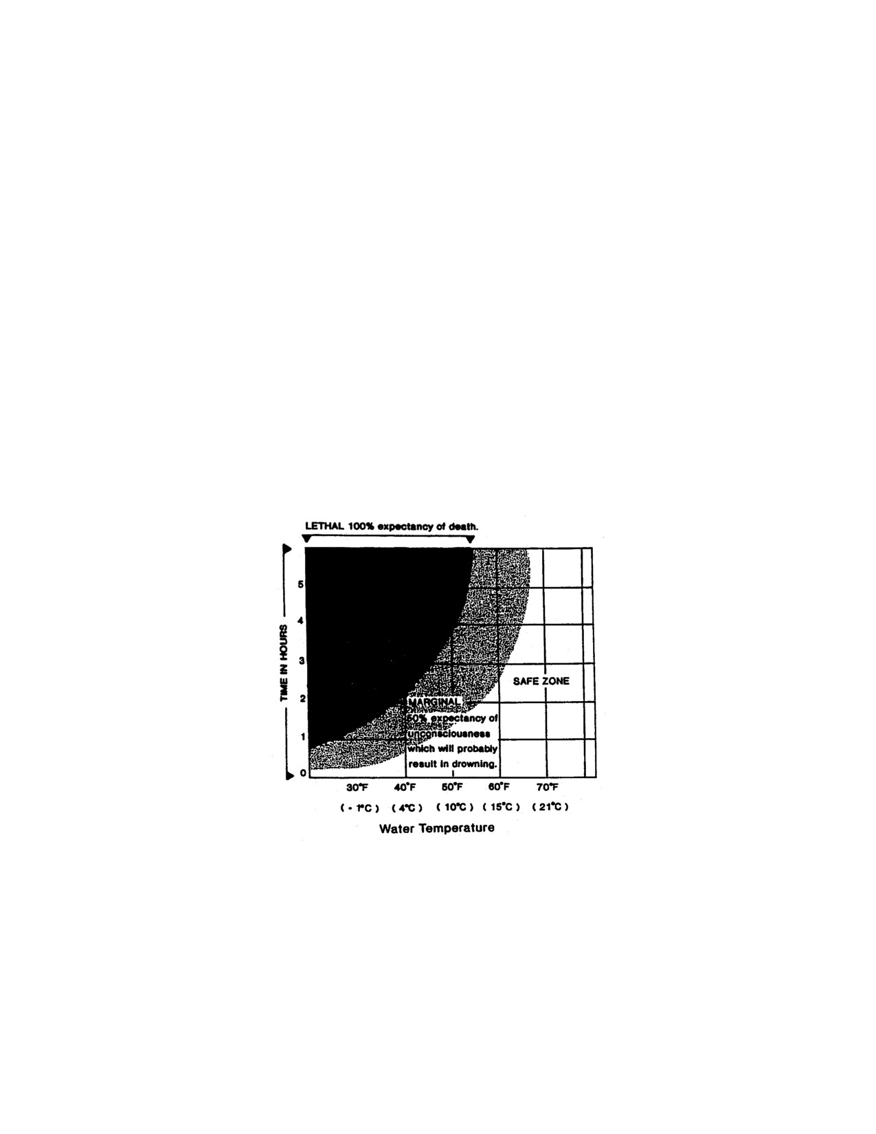
NATO-UNCLASSIFIED
ATP-17(C)
CHAPTER 16
SURVIVAL
1601 INTRODUCTION
1. Impressive advances continue to be made in the development of clothing and equipment for
survival.
2. One of the most important requirements for survival is a capacity to accept immediately the reality
of an emergency and an ability to react appropriately to it.
3. Acquaintance with survival technique is an important factor affecting one's ability to stay alive.
Relevant knowledge and training may be put directly to use in meeting the emergency, and will also
contribute to a feeling of confidence whereby fear is reduced and panic prevented.
1602 COLD
1. Seawater temperatures in the Arctic vary from -1° C to 1.6° C. A person struggling in water at
these temperatures might last from 3 to 5 minutes. Therefore, the numbing shock of bitter cold water
and accompanying wind-chill is the paramount factor influencing most Arctic marine survival
situations (see Figure 16-1 and Table 16-1).
Figure 16-1 Survival Chart
2. For details concerning the symptoms and treatment of hypothermia, immersion foot, frostbite and
snow-blindness, refer to Chapter 9.
16-1
ORIGINAL
NATO-UNCLASSIFIED
NATO-UNCLASSIFIED
ATP-17(C)
1603 PERSON OVERBOARD
1. Whether at anchor or alongside, all ships must have an effective organization to watch for people
who may fall overboard. This lookout organization should also maintain a constant watch on laden
boats ferrying people and cargo ashore or between ships.
2. In a person-overboard situation, use a lifebuoy to mark the spot where the victim may be located.
Another alternative for cold waters is an inflatable life raft fitted with a drogue to prevent it from being
blown out of reach.
3. After casting a lifebuoy or raft over the side, the ship must make an effort to recover the person by
manoeuvring into a suitable position just as quickly as type and size will permit. A good ship-handler,
who has not only thought out the problem beforehand but has also rehearsed it, may make all the
difference between a corpse and a case of severe hypothermia. Ships fitted with Rigid Inflatable Boats
(RIB) will normally find that these craft provide the fastest means of recovering a casualty from the
water, provided they and their crews are kept at a high level of readiness. A swimmer, prepared to
enter the cold water, must be ready to go over the side the instant the ship is laid alongside the victim;
the swimmer should be tethered and have another line with which to aid the victim.
4. Any person rescued from cold water will require immediate, expert medical care as will the
rescuer.
5. In circumstances when it would be impossible to stop, an escort may have to be diverted. A
suitably equipped rescue helicopter, nearby and ready for action, as would be the case in a carrier
force-operating aircraft, is a helpful alternative.
1604 ABANDON SHIP
1. Inflatable life rafts have come a long way in design, reliability and capacity. They inflate
automatically, complete with weather canopies, in about 30 seconds. In a growing number of ships
the life-saving role is being switched from boats to inflatable rafts because of their efficiency. If ships
on Arctic service are supplied with rafts sufficient to accommodate one and a half times the ship's
crew, the chances of group survival will be much improved.
2. If inflatable rafts are to be effective lifesaving devices, crew must be trained on how to use them.
One raft should be supplied to every ship for instructional purposes on a permanent basis.
3. Rafts should be equipped with high-intensity lights and larger rafts should have some electronic
means of homing rescue forces. Radar reflectors, depending upon winds and local ice conditions, may
prove helpful in aiding detection by rescue forces.
1605 IMMERSION SUITS
1. In the Arctic, aircrew should wear immersion suits or wet suits for over-water flights in fixed-wing
aircraft.
2. Aircrew of small helicopters may be given some discretion in choice of cold-weather clothing if
they are operating over an area where there is a significant amount of sea ice. In such circumstances
the sea is usually calm and helicopters can put down on the ice, or if equipped with floats (as they
should be for Arctic operations) sit on the water with little fear of being upset.
ORIGINAL
16-2
NATO-UNCLASSIFIED
NATO-UNCLASSIFIED
ATP-17(C)
3. Large helicopters, must be equipped with some form of emergency flotation, and aircrew should
always wear immersion suits for over-water operations. An exception could be made to this rule if
flying is to take place over fast ice, or where there are heavy floes covering at least 5/10 of the sea and
which are thick enough to support the weight of the machine.
4. A "quick-donning" immersion suit has been developed by both the Unites States Navy and the
Royal Navy for use by helicopter passengers and others who may become involved in a short-term
Arctic survival situation. Made of a lightweight rubberized vinyl material, International Orange in
colour, these waterproof suits are intentionally large and loose-fitting garments intended to be worn
over a person's clothing but inside a life jacket. Because of their generous dimensions, they are easy
and quick to don and fit all shapes and sizes with equal facility. Neck and wrists are elasticized to
keep water out. By providing protection for those who would otherwise surely succumb to the effect
of an involuntary immersion in very cold water, these suits could be the means of saving many lives.
1606 HELICOPTER SURVIVAL EQUIPMENT
1. The amount of survival equipment which can be carried in a helicopter must obviously be kept to a
minimum, but the following items are considered essential for Arctic operations.
a. Shelter tent (two-person capacity).
b. Emergency rations (10 days per person).
c. Emergency radio.
d. Rifle and ammunition (30-06 or equivalent, and 50 rounds).
e. Axe.
f. Signalling mirror plus flares and smoke bombs.
g. Two-burner Coleman stove and fuel.
2. It is an accepted rule among those who travel in the Arctic to always have their sleeping bags with
them in case of an emergency or even an unexpected change in plan. But sleeping bags (and tents,
stoves, etc) are bulky items and for naval operations a special decision would be required specifying
precisely what survival equipment should be carried for the shipborne helicopter operations envisaged.
1607 EMERGENCY AIRCRAFT LANDINGS IN THE ARCTIC
1. Immediate Action - Forced Landing on Land
a. Remain away from the aircraft until engines have cooled and spilled fuel has evaporated.
b. Check for injuries, administer first aid and make the injured comfortable.
c. Keep snow brushed from clothing and avoid getting wet.
d. Erect a temporary shelter. If necessary start a fire; make hot drinks.
e. Salvage all personal and aircraft emergency gear from the aircraft.
16-3
ORIGINAL
NATO-UNCLASSIFIED

NATO-UNCLASSIFIED
ATP-17(C)
f. Drain the oil and let it fall on the snow where it can congeal; it can be used for fuel later.
Congealed oil can also be used for smoke signal fires.
Table 16-1 Wind - Chill Temperatures Chart (°C)
ORIGINAL
16-4
NATO-UNCLASSIFIED
NATO-UNCLASSIFIED
ATP-17(C)
g. Make sure the emergency radio or the aircraft radio is operational. If no contact, supplement
voice communications with emergency radio signals on a scheduled basis.
h. Do not try to live in the aircraft - it will be too cold. At first glance, the aircraft seems a logical
shelter but is a poor one. There is no possibility of bringing the inside temperature above the
ambient temperature. The fuselage, exposed to piercing winds, will act as a heat sink that will
drain away body reserves and emergency supplies.
i. Assign specific duties to each individual in the survival group.
j. Prepare signals so the group can be spotted from the air.
k. Start a logbook. Include date, cause of forced landing; probable location and celestial
observations.
l. Determine the position by the best means available and include this in radio messages.
m. Conserve electrical power.
n. On hearing an aircraft, sweep the horizon with a signal mirror at frequent intervals.
2. Decision to Stay or Leave Aircraft
a. It is usually best to stay with the aircraft and await rescue. Most rescues are made when people
remain with their aircraft because, with current search and rescue procedures, the general vicinity
of your position will be known. A downed aircraft also makes a good radar target.
b. A downed aircraft should be left only when:
(1) The position is certain and it is also certain that with available equipment and resources,
shelter, food and help can be reached.
(2) After waiting several days, it is obvious that rescue is not immediate.
3. Immediate Action-Forced Landing on the Ice
a. Evacuate the aircraft immediately and take care of the injured. If the ice is thin, the aircraft will
depress the ice and may eventually break through.
b. Check clothing to ensure it provides maximum possible protection against cold and wet
weather.
c. Establish a temporary shelter, at least 45 metres from the aircraft. If possible build a fire inside.
d. Attempt to establish radio contact with anyone, station, ship or aircraft, and in so doing
establish a systematic procedure.
e. Survey the area to determine the safest campsite. Seek a thick ice floe in the general vicinity of
the aircraft. Do not camp on a young (smooth) ice floe which maybe thin and will be the first to
break up. Consider the availability of food and water and the distance to the downed aircraft.
16-5
ORIGINAL
NATO-UNCLASSIFIED
NATO-UNCLASSIFIED
ATP-17(C)
f. Build a camp. Do not use the aircraft as a shelter unless absolutely necessary.
g. Find and mark a safe landing area for rescue planes and/or helicopters.
h. Stay together.
i. Unless it is known that land is within walking distance, it is best to remain as close to the
landing site as ice conditions will permit.
4. Immediate Action-Forced Landing in the Sea
a. Activate and board liferafts. Stay clear of aircraft and out of fuel-covered waters, but remain in
the vicinity of the aircraft until it sinks.
b. Search for missing personnel.
c. Salvage floating equipment. Stow and secure all items and check raft for inflation leaks and
points for possible chafing.
d. In cold weather DON exposure suits. Rig a windbreak, spray shield and canopy. Huddle
together; exercise regularly.
e. Check physical condition of all aboard and administer first aid, if necessary.
f. If there is more than one raft, join them together loosely at the lifeline around the outer side of
the raft.
g. Make sure the emergency radio is operational. Use emergency transceiver when aircraft are
known to be in the area. Prepare other signals for instant use.
h. Keep compasses, watches and lighters dry and in waterproof containers.
i. Keep a log. Record the best navigation data available. Also record the direction of the wind,
swells and times of sunrise/sunset.
j. Save water and food by saving energy, and ration if necessary.
k. Keep signal mirrors handy; use the signal panel and dye marker whenever an aircraft is in the
vicinity.
l. Don any extra clothes available. Keep clothes loose and comfortable. Try to keep the floor of
the raft dry, and for insulation cover it with canvas or cloth.
m. Take mild exercise to restore circulation. Repeatedly bend and open fingers and toes. Exercise
shoulder and buttock muscles.
n. Warm hands under armpits. Periodically raise the feet and hold them in that position for a
minute or two. Move face muscles frequently to detect frostbite. Shivering is normal. It is the
body's method of quickly generating heat.
o. Give extra rations to men suffering from cold exposure.
ORIGINAL
16-6
NATO-UNCLASSIFIED
NATO-UNCLASSIFIED
ATP-17(C)
p. Put out the sea anchor immediately. A sea anchor properly used will hold a raft into the wind,
check drift and provide the best and often the only means of steadying the raft in a seaway to
prevent broaching and capsizing. Do not attempt to navigate a raft unless land is in sight or land is
within a reasonable distance. Take every precaution to prevent the raft from turning over. In rough
weather the crew should sit low with their weight distributed to hold the weather side down.
q. Do not sit on the sides of or stand up in the raft. There should be no sudden movements
without prior warning. Every precaution must be taken to keep the raft stable and dry.
1608 OCEAN SURVIVAL
1. Living Wlthout Food and Water. Do not eat if there is a lack of water. The body uses up water in
digestingfood, and the elimination of waste products also draws water from the tissues.
2. Water
a. Rain and ice are good sources of fresh, potable water.
b. Do not drink seawater. It increases thirst and, by drawing body fluids from the kidneys and
intestines, can cause convulsions and delirium.
c. Do not drink urine.
3. Food
a. Fish found in the Arctic are edible, either raw or cooked. None is known to be poisonous. The
heart, liver and blood of fish are edible, but the intestines should be avoided unless cooked.
Stomachs of large fish may contain partially digested fish, which are also edible. Fish eyes contain
a large percentage of water. Some fish eggs are, however, poisonous and those found growing in
clusters or clumps on rocks or reefs should not be eaten.
b. Never fasten a fishing line to anything solid, it may snap when a large fish strikes. Fish are
more apt to see and strike at moving bait. Any part of the flesh of a bird or fish makes good bait
and it need not he fresh.
c. When fishing, vary the time of day and the depth of the bait to catch different species. Many
fish come to the surface at night, and may be attracted by lights.
d. Seaweed is tough and salty, absorbs water from the intestines and is difficult to digest. Eat it
only if plenty of water is available.
e. Small edible crabs, shrimps and fish inhabit coastal seaweed and patches of sargasso at sea.
Use a drag behind a raft or boat to collect the seaweed, then shake it to catch the food.
f. All sea birds are edible and nourishing, though not always flavoursome. Gulls, albatrosses,
terns and gannets can be caught by dragging a baited fishhook behind a raft. A flat sharp-edged
triangular piece of metal dragged behind a float will bring gulls or albatrosses within shooting
range. Gannets, once settled on a raft, often display little fear of man and are easily caught.
g. Marine molluscs such as oysters, clams, scallops, whelks, periwinkles, barnacles and conches
are in practically inexhaustible supply throughout the world. They can be eaten cooked or raw.
16-7
ORIGINAL
NATO-UNCLASSIFIED
NATO-UNCLASSIFIED
ATP-17(C)
1609 CARBON-MONOXIDE POISONING
1. Everyone must be constantly alert for the possibility of carbon-monoxide poisoning resulting from
incomplete combustion of fuel. Use of petroleum products in internal-combustion engines and stoves
in the Arctic is a common source of carbon-monoxide poisoning.
2. Those who take refuge in tents, snow houses, or other Arctic shelters must be aware that
ventilation may be inadequate or ventilators may become blocked. This warning also applies to boats
and vehicles where ventilators may become obstructed or exhaust pipes plugged by snow.
3. It is essential to provide active ventilation in tents and other shelters even if this means some loss
of precious heat to incoming cold air. Leaded gasoline burned in stoves produces lead oxides which
are irritating but non-toxic in small amounts. Smarting eyes, running nose or coughing produced by
these are a warning of carbon-monoxide buildup.
4. Treatment is to move the subject into the fresh air, and if necessary, apply artificial respiration.
Give 100 percent oxygen. Keep warm and quiet in bed for at least 8 hours. Too early exertion may
produce heart failure.
1610 DANGEROUS ARCTIC ANIMALS
1. The most dangerous animal to an Arctic survivor is the polar bear. This large and powerful
carnivore inhabits the coastal regions of the Arctic, is truly nomadic, and wanders the ice-pack year-
round in search of food.
2. Bears, being afraid of nothing, are understandably inquisitive and curious of man. Their behaviour
should not be mistaken for aggressiveness or hostile intent at the outset. They may be discouraged and
frightened off by loud noises and activity.
3. Unless a person's life is actually threatened, it is wiser not to shoot a bear since he is an
exceedingly difficult animal to kill. The head shot is not recommended because the shape of the skull
may simply deflect a bullet. Furthermore, a bear bobs his head and moves it from side to side, offering
a continually moving target. The shoulder shot is preferred.
4. A bear with cubs is extremely dangerous if molested. To approach a polar bear cub, whether or not
its mother is nearby, is to invite certain retaliation.
5. Polar bear meat makes good eating but trichinosis is widespread in bear meat as in most other
Arctic animals. All meat must, therefore, be cooked for a long time to destroy the parasitic worms.
The liver of the bear is poisonous and must not be eaten.
6. Musk-oxen are found in some parts of the Arctic and are not dangerous unless approached.
7. Arctic wolves (white in winter, dirty grey in summer) are normally frightened of man but can
become aggressive.
1611 WINTERING IN
1. The key to ship protection in the pack is to ensure that pressure, where unavoidable, will be
applied uniformly throughout the ship's length. The ship should be worked in between uniformly thick
floes of nearly equal size, with no polynyas or open leads nearby. These floes will cushion the
ORIGINAL
16-8
NATO-UNCLASSIFIED
NATO-UNCLASSIFIED
ATP-17(C)
pressure which is bound to be experienced during the constant movement of the pack and, if a break-
up occurs, provide a measure of protection.
2. A ship compelled to winter in should select a harbour where protection from driving ice is afforded
to seaward by rocks, shoals or islands. The best protected harbour is a narrow, deep, fiord-like channel
where mooring lines can be run ashore. The practicability of rigging cables athwart the seaward side of
the refuge, to impede ice which might otherwise drift down upon the ship, should be investigated.
Moor in shallow water, making allowance for the height of the seas and the tidal range to be
experienced. Lay out wires and anchor cables to suitable mooring ashore.
3. A good fresh water supply is an important consideration if there is any doubt about the ability of
the ship's evaporators to function throughout the winter. Glacial ice gives roughly twice the water per
fuel unit in half the time that snow does when melted, and it is also cleaner. To be on the safe side, all
drinking water should be purified either by boiling or by chlorination.
4. The direction of the wind must be considered. The ship and any objects which may be stored on
the ice nearby, should be aligned with the least dimension facing the prevailing wind to reduce the
formation of snow drifts.
5. The following steps should be taken in laying up the ship:
a. Diesel Machinery. The seawater intake to the engines should be securely closed. All drain
cocks, plugs or valves in the lowest parts of water pumps, coolers, piping and exhaust manifolds
should be kept open. An inspection should be made to ensure that no water remains in pockets or
low points in the engine water systems. Lubricating oil should be sprayed into the combustion
space. After this, the engine should be turned over a few revolutions. The fuel oil valve between
the fuel day tank and the engine should be closed. All openings leading from the outside to the
engine must be sealed shut to prevent snow and moisture from entering. All air in the starting
systems should be blown out to eliminate moisture, and air tanks left charged at normal starting
pressures. Mufflers and water traps in diesel exhaust system should be drained.
b. Boilers. All water sides and piping should be completely drained and blown out with air.
Drain cocks must be opened. The fuel oil manifold on the burner front should be disconnected,
drained and then be tightly plugged. All openings such as smoke pipes, vents, drain connections,
access doors, observation ports and other openings to the atmosphere should be covered and
sealed to obtain the best possible leak-proofing. The water sides of all heat exchangers should also
be drained and blown out with air.
c. Condensers. The steam sides of condensers should be drained. Both sides to air ejectors to the
inner and outer condensers (steel) should also be drained.
d. Auxiliary Equipment. Auxiliary equipment which is not to be used, should be drained. To
prevent the formation of sludge, oil should be removed from the lubrication oil cooler.
e. Steam Turbine and Gears. All accumulated water must be drained from pockets or low parts
of the turbines. The lubricating oil system and gears need no special preservation.
f. Steam Piping Systems. All steam supply and drain valves in fuel oil heating systems to each
fuel oil tank, after a system has been laid up, should be kept in a closed position. All steam drain
valves and steam trap by-pass valves not required to be closed should be left open. Regulator
valves, reducing valves, steam traps and other controls in piping systems which cannot be
16-9
ORIGINAL
NATO-UNCLASSIFIED
NATO-UNCLASSIFIED
ATP-17(C)
thoroughly drained and dried without dismantling, should be taken down, repaired, dried and
reassembled.
g. Aviation Fuel System. All salt water and gasoline must be pumped or drained from tanks and
lines. The system should be charged with CO2.
h. Water, Air and Flushing Systems. Except where protected by antifreeze solutions, all the
water must be completely drained from the systems; where practicable they should be blown clear
and dry by compressed air. All tanks in the system which are in a charged condition should be
disconnected or otherwise isolated. Moisture must be removed from moisture traps and blown out
of the entire air system. Shipboard toilets should be completely drained unless antifreeze solutions
are to be left in the traps. All traps, reducing valves and lines in the flushing system must be
completely drained. All bilges and water accumulations should be wiped dry.
i. SeaWater Cooling and Suction Sea- Chests. These should be blown out with compressed air
and an airlock maintained between the valve disc and seawater.
j. Stern Tube Bearing, Rudder and Propellers. The salt-water flushing connection in the stern
tube bearing should be shut off or secured. All water from this system must be drained and the
stern tube gland tightened up so there is no trickle of water, normally present for lubricating
purposes. Propeller blades should be aligned so that they will suffer the least damage from future
ice pressure. The rudder must be secured amidships.
6. Garbage and sewage disposal could become a problem and arrangements would be necessary to
prevent effluent from accumulating alongside the ship.
7. Probably the greatest danger to a ship or camp wintering in the Arctic is fire. With strong
winds to spread it, and lack of water to fight it, fire can destroy a camp in short order. A ship's crew
could be forced to take to the ice, and plans should be laid for just such an eventuality before it
happens.
ORIGINAL
16-10
NATO-UNCLASSIFIED
NATO-UNCLASSIFIED
ATP-17(C)
Annex A
Conversion Charts
A-1
ORIGINAL
NATO-UNCLASSIFIED
NATO-UNCLASSIFIED
ATP-17(C)
ORIGINAL
A-2
NATO-UNCLASSIFIED

NATO-UNCLASSIFIED
ATP-17(C)
A-3
ORIGINAL
NATO-UNCLASSIFIED

NATO-UNCLASSIFIED
ATP-17(C)
ORIGINAL
A-4
NATO-UNCLASSIFIED

NATO-UNCLASSIFIED
ATP-17(C)
A-5
ORIGINAL
NATO-UNCLASSIFIED
NATO-UNCLASSIFIED
ATP-17(C)
ORIGINAL
A-6
NATO-UNCLASSIFIED
NATO-UNCLASSIFIED
ATP-17(C)
A-7
ORIGINAL
NATO-UNCLASSIFIED

NATO-UNCLASSIFIED
ATP-17(C)
ORIGINAL
A-8
NATO-UNCLASSIFIED
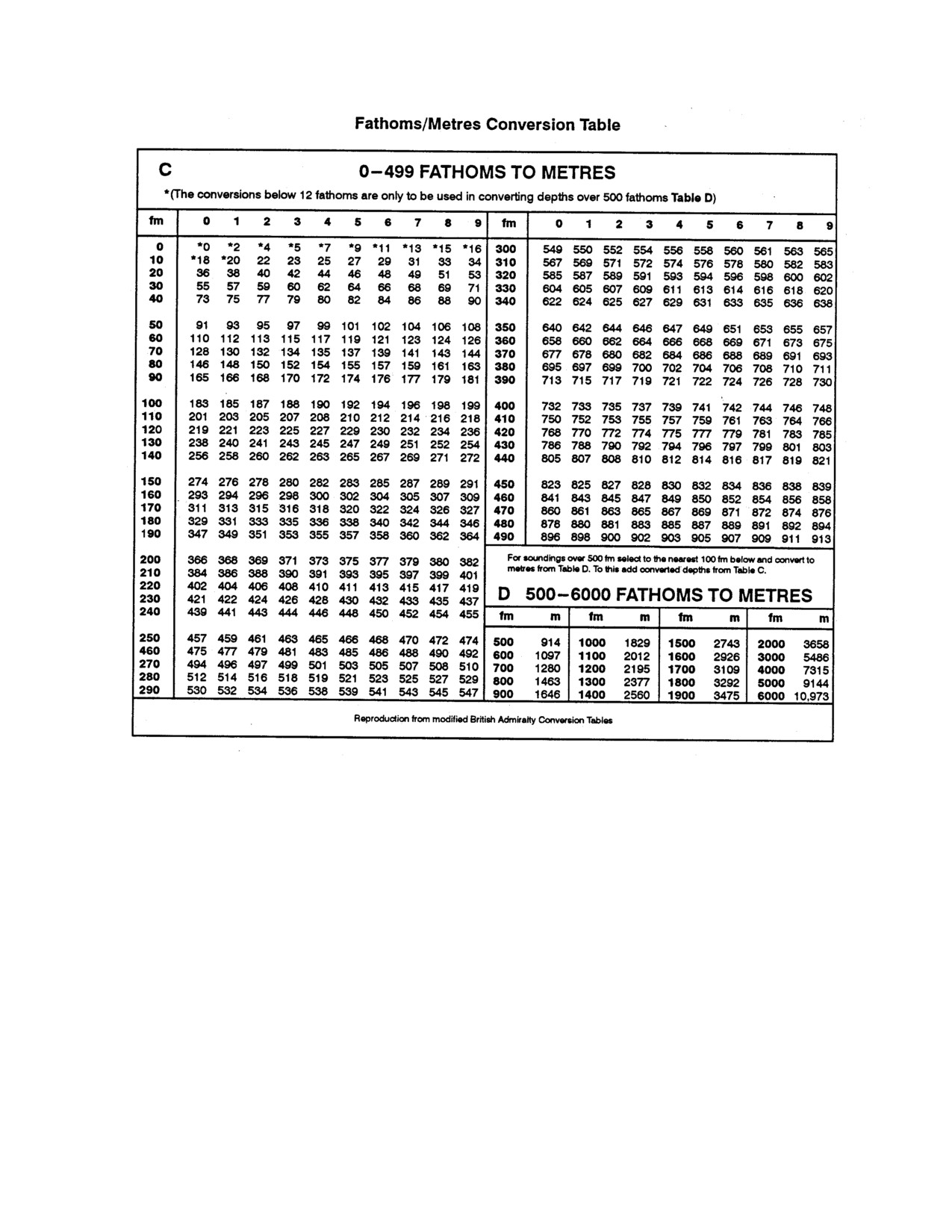
NATO-UNCLASSIFIED
ATP-17(C)
A-9 (Reverse Blank)
ORIGINAL
NATO-UNCLASSIFIED
INTENTIONALLY BLANK
NATO-UNCLASSIFIED
ATP-17(C)
ANNEX B
GLOSSARY OF ICE TERMS
A
Aged Ridge. Ridge which has undergone considerable weathering. These ridges are best described as
undulations.
Anchor Ice. Submerged ice attached or anchored to the bottom, irrespective of its formation.
Area of Weakness. A satellite-observed area in which either the ice concentration or the ice thickness
is significantly less than that in the surrounding areas. Because the condition is satellite observed, a
precise quantitative analysis is not always possible, but navigation conditions are significantly easier
than in surrounding areas.
Auroral Zones. Zones of variable RF propagation in higher !atitudes, due to charged particles ejected
from the sun and deflected by the earth's magnetic fields.
B
Bare Ice. Ice without snow cover.
Beaufort Gyre. A current system centred near 78° N 140° W which moves ice in a counter-clockwise
rotation before dispersing it into the Transpolar Drift or along the coasts of Ellesmere Island and
Greenland.
Belt. A large feature of ice arrangements, longer than it is wide; from 1 km to more than 100 km in
width.
Bergy Bit. A large piece of floating glacier ice, generally showing less than 5 metres above sea-level
but more than 1 metre, and normally about 100-300 square metres in area.
Bergy Water. An area of freely navigable water in which glacier ice is present in concentrations of
less than 1/10. There may be sea ice present, although the total concentration of all ice shall not exceed
1/10.
Beset. Situation of a vessel surrounded by ice and unable to move.
Big Floe. (see Floe).
Bight. Extensive crescent-shaped indentation in the ice edge, formed by either wind or current.
Brash Ice. Accumulations of floating ice made up of fragments not more than 2 metres across, the
wreckage of other forms of ice.
Bummock. From the point of view of the submariner, a downward projection from the underside of
the ice canopy-, the counterpart of a hurnmock.
C
Calving. The breakingaway of a mass of ice from an ice wall, ice front, or iceberg.
B-1
ORIGINAL
NATO-UNCLASSIFIED
NATO-UNCLASSIFIED
ATP-17(C)
Close Ice. Floating ice in which the concentration is 7/10 to 8/10, composed of floes mostly in contact.
Compacted Ice Edge. Close, clear-cut ice edge compacted by wind or current; usually on the
windward side of an area of ice.
Compact Ice. Floating ice in which the concentration is 10/10 and no water is visible.
Compacting. Pieces of floating ice are said to be compacting when they are subjected to converging
motion, which increases ice concentration and/or produces stresses which may result in ice
deformation.
Concentration. The ratio expressed in tenths of the sea surface actually covered by ice to the total
area of sea surface, both ice-covered and ice-free, at a specific location or over a defined area.
Concentration Boundary. A line approximately the transition between two areas of drift-ice with
distinctly different concentrations.
Consolidated Ice. Floating ice in which the concentration is 10/10 and the floes are frozen together.
Consolidated Ridge. A ridge in which the base has frozen together due to melting or other processes.
Crack. Any fracture which has not parted.
D
Dark Nilas. Nilas which is under 5 cm in thickness and is very dark in colour.
Deformed Ice. A general term for ice which has been squeezed together and in places forced upwards
(and downwards). Subdivisions are rafted ice, ridged ice, and hummocked ice.
Dehydration. A lack of sufficient fluid intake to make up for fluids lost.
Diffuse Ice Edge. Poorly defined ice edge limiting an area of dispersed ice; usually on the leeward
side of an area of pack ice.
Diverging. Ice-fields or floes in an area are subjected to diverging or dispersive motion, thus reducing
ice concentration and/or relieving stresses in the ice.
Dried Ice. Sea ice from the surface of which melt-water has disappeared after the formation of cracks
and thaw holes. During the period of drying, the surface whitens.
Drift-Ice. Sea ice that is drifting freely.
E
Embrittlement. The process of materials becoming brittle from extreme cold weather.
F
Fast Ice. Sea ice that forms and remains is attached to the coast in late winter.
ORIGINAL
B-2
NATO-UNCLASSIFIED
NATO-UNCLASSIFIED
ATP-17(C)
Fast Ice Boundary. The ice boundary at any given time between fast ice and drift-ice.
Fast Ice Edge. The demarcation at any given time between fast ice and open water.
Finger-Rafted Ice. Type of rafted ice in which floes thrust "fingers" alternately over and under one
another.
Finger-Rafting. Type of rafting whereby interlocking thrusts are formed, each floe thrusting "fingers"
alternately over and under one another. Common in nilas and grey ice.
Firn. Old snow which has recrystallized into a dense material. Unlike ordinary snow, the particles are
to some extent jointed together; but, unlike ice, the air spaces in it still connect with each other.
First-Year Ice. Sea ice of not more than one winter's growth; thickness varies from 30 cm to 2 m,
generally white in colour.
Flaw. A narrow separation zone between drift-ice and fast ice, where the pieces of ice are in chaotic
state; it forms when drift - ice shears under the effect of a strong wind or current along the fast ice
boundary.
Flaw Lead. A passageway between drift-ice and fast ice which is navigable by surface vessels.
Flaw Polynya. A polynya between drift-ice and fast ice.
Floating Ice. Any form of ice found floating in water. The principal kinds of floating ice are lake ice,
river ice, and sea ice, which form by the freezing of water at the surface, and glacier ice (ice of land
origin) formed on land or in an ice shelf. The concept includes ice that is stranded or grounded.
Floe. Any relatively flat piece of sea ice 20 m or more across. Floes are subdivided according to
horizontal extent aa fall..wa
Giant: Over 10 km across
Vast:
2-10 km across
Big:
500-2 000 m across
Medium:
100-500 m across
Small:
20-100 m across
Floeberg. A massive piece of sea ice composed of a hummock, or a group of hummocks frozen
together, and separated from any ice surroundings. It may typically protrude up to 5 m above sea-
level.
Floebit. A relativelysmall piece of sea ice, normally not more than 10 m across, composed of a
hummock(s) or part of a ridge(s) frozen together and separated from any surroundings. It typically
protrudes up to 2 m above sea-level.
Flooded Ice. Sea ice which has been flooded by melt-water or river water and is heavily loaded by
water and wet snow.
Fracture. Any break or rupture through very close ice, compact ice, consolidated ice, fast ice, or a
single floe, resulting from deformation processes. Fractures may contain brash ice and/or be covered
with nilas and/or young ice. Length may vary from a few metres to many kilometres.
B-3
ORIGINAL
NATO-UNCLASSIFIED
NATO-UNCLASSIFIED
ATP-17(C)
Fracture Zone. An area which has a great number of fractures.
Fracturing. Pressure whereby ice is permanently deformed, and rupture occurs. Most commonly used
to describe breaking across very dose ice, compact ice, and consolidated ice.
Frazil Ice. Fine spicules or plates of ice suspended in water.
Free Communication. Occurs if the hull is ruptured so that one or more compartments are open to the
sea.
Free Surface. Effect from ship's tank(s) or void(s) when only partially filled and the liquid contents
"slosh" back and forth.
FreshwaterIcing. When ice form on the ship's surfaces form drops of rain, damp snow or other fresh
water source.
Frostbite. The freezing of any part of the body. The water in the tissue cells turns to ice and disrupts
the normal function of the tissue.
Frostnip. Superficial frostbite, affecting only the skin or the tissue irnmediately beneath it.
Friendly Ice. From the point of view of the submariner, an ice canopy containing many large
skylights or other features which permit a submarine to surface. There must be more than 10 such
features per 30 nautical miles (56 km) along the submarine's track.
Frost Smoke. Fog-like clouds due to the contact of cloud air with relatively warm water, which can
appear over openings in the ice, or leeward of the ice edge, and which may persist while ice is
forming.
G
Glacier. A mass of snow and fresh water ice continuously moving from higher to lower ground or, if
afloat, continuously spreading. The principal forms of glacier are: inland ice sheets, ice shelves, ice
streams, icecaps, ice piedmonts, cirque glaciers, and various types of mountain (valley) glaciers.
Glacier Berg. An irregularly shaped iceberg.
Glacier Ice. Ice in, or originating from, a glacier, whether on land or floating on the sea as icebergs,
bergy bits, or growlers.
Glacier Tongue. Projecting seaward extension of a glacier, usually afloat. In the Antarctic, glacier
tongues may extend over many tens of kilometres.
Grease Ice. A later stage of freezing than frazil ice, when the crystals have coagulated to form a soupy
layer on the surface. Grease ice reflects little light, giving the sea a matte appearance.
Green Water. Solid seawater (waves), not sea spray, which comes over the ship when in heavy seas.
Is dangerous because it can damage equipment, break windshields and antennas and can wash people
overboard.
Grey Ice. Young ice 10-15 cm thick. Less elastic than nilas, it breaks on swell. Usually rafts under
pressure.
ORIGINAL
B-4
NATO-UNCLASSIFIED
NATO-UNCLASSIFIED
ATP-17(C)
Grey-White Ice. Young ice 15-30 cm thick. Under pressure, more likely to ridge than raft.
Grounded Hummock. Hummocked, grounded ice formation. There are single grounded hummocks
and lines (or chains) of grounded hummocks.
Grounded Ice. Floating ice which is aground in shoal water.
Growler. Smaller piece of ice than a bergy bit or floeberg, (about the size of a piano) often transparent
but appearing green or almost black in color, extending less than 1 m above the sea surface.
H
Halo. Commonly a ring of light of radius 22 or 46 with the sun or moon at the centre, caused by
refraction of light by ice crystals in the atmosphere. Occasionally, a faint circle with a radius of 90
appears around the sun.
Hostile Ice. From the point of view of the submariner, an ice canopy containing no large skylights or
other features which permit a submarine to surface.
Hummock. A hillock of broken ice which has been forced upwards by pressure. May be fresh or
weathered. The submerged volume of broken ice under the hummock, forced downwards by pressure,
is termed a hummock.
Hummocked Ice. Sea ice piled haphazardly one piece over another to form an uneven surface. When
weathered, has the appearance of smooth hillocks.
Hummocking. The pressure process by which sea ice is forced into hurnmocks. When the floes rotate
in the process it is termed screwing.
Hypothermia. A condition that occurs when the body is unable to maintain adequate warmth and the
body core temperature drops below normal.
I
Ice Accretion. The building up of ice which occurs when airborne moisture comes in contact with
cold metal.
Iceberg. A large mass of floating ice broken away from a glacier or a large mass of ice, floating or
around, that has calved from a glacier, i.e., fresh water ice.
Iceberg Tongue. A major accumulation of icebergs projecting from the coast, held in place by
grounding and joined together by fast ice.
Iceblink. A whitish glare on the underside of low clouds caused by the sun's reflection off the surface
of pack ice.
Ice-Bound. A harbour, inlet, etc. is said to be ice-bound when navigation by ships is prevented on
account of ice, except possibly with the assistance of an ice-breaker.
Ice Boundary. The demarcation at any given time between fast ice and drift-ice, or between areas of
drift-ice of different concentrations.
B-5
ORIGINAL
NATO-UNCLASSIFIED
NATO-UNCLASSIFIED
ATP-17(C)
Ice Breccia. Ice of different stages of development frozen together.
Ice Cake. Any relatively flat piece of sea ice from 2 m to 20 m across.
Ice Canopy. Drift-ice from the point of view of the submariner.
Ice Cover. The ratio of an area of ice of any concentration to the total area of sea surface within some
large geographic locale; this locale may be global, hemispheric, or prescribed by a specific
oceanographic entity such as Baffin Bay or the Barents Sea.
Ice Edge. The demarcation at any given time between the open sea and sea ice of any kind.
Ice-Field. Area of floating ice consisting of any size of floes, which is greater than 10 km across.
Ice-Foot. A narrow fringe of ice attached to the coast, unmoved by tides, and remaining after the fast
ice has moved away.
Ice-Free. An area with no ice present. If ice of any kind is present, the area is not ice-free.
Ice Front. The vertical cliff forming the seaward face of an ice shelf or other floating glacier varying
in height from 2-50 m or more above sea-level.
Ice Island. A large piece of floating ice, protruding about 5 m above sea-level, which has broken away
from an ice shelf. It has a thickness of 30-50 m and an area of from a few thousand square metres to
500 km2 or more, and is usually characterized by a regularly undulating surface which gives it a
ribbed appearance from the air.
Ice Isthmus. A narrow connection between two ice areas of very close or compact pack-ice. It may be
difficult to pass, yet sometimes being part of a recommended route.
Ice Jam. An accumulation of broken river ice or sea ice caught in a narrow channel.
Ice Keel. From the point of view of the submariner, a downward-projecting ridge on the underside of
the ice canopy; the counterpart of a ridge. Ice keels may extend as much as 50 m below sea-level.
Ice Limit. Climatological term referring to the extreme minimum or extreme maximum extent of the
ice edge in any given month or period based on observations over a number of years. Term should be
preceded by minimum or maximum.
Ice Massif A variable accumulation of close or very close pack-ice covering hundreds of square
kilometres which is found in the same regions every summer.
Ice of Land Origin. Ice formed on land or in an ice shelf, found floating in water. The concept
includes ice that is stranded or grounded.
Ice Patch. An area of floating ice less than 10km across.
Large Fracture. More than 500 m wide.
Large Ice-Field. An ice-field over 20 km across.
ORIGINAL
B-6
NATO-UNCLASSIFIED