Military reference books and manuals (2009-2023, Volume 5) - page 25
NASWHIDBEYINST 3770.1E
12 Jul 10
5.2.4 Warning Area W-237D
1. Beginning at:
47º 00' 00"N 125º 28' 03"W to
46º 49' 59"N 125º 24' 05"W to
46º 53' 24"N 125º 06' 47"W to
46º 32' 00"N 125º 18' 00"W to
46º 06' 00"N 126º 15' 00"W to
47º 00' 00"N 126º 15' 00"W to
the point of beginning.
2. Altitudes: Surface to unlimited
5.2.5 Warning Area W-237E
1. Beginning at:
48º 29' 37"N 125º 09' 01"W to
48º 08' 59"N 125º 05' 00"W to
48º 08' 59"N 127º 54' 44"W to
48º 20' 00"N 128º 00' 00"W to
the point of beginning.
2. Altitudes: Surface to FL270.
5.2.6 Warning Area W-237F
1. Beginning at:
48º 08' 59"N 126º 15' 00"W to
47º 00' 00"N 126º 15' 00"W to
47º 00' 00"N 127º 22' 26"W to
48º 08' 59"N 127º 54' 44"W to
the point of beginning.
2. Altitudes: Surface to unlimited
5.2.7 Warning Area W-237G
1. Beginning at:
47º 00' 00"N 126º 15' 00"W to
46º 06' 00"N 126º 15' 00"W to
45º 48' 35"N 126º 50' 49"W to
47º 00' 00"N 127º 22' 26"W to
the point of beginning.
2. Altitudes: Surface to unlimited
5-3
NASWHIDBEYINST 3770.1E
12 Jul 10
5.2.8 Warning Area W-237H
1. Beginning at:
48º 20' 00"N 128º 00' 00"W to
47º 00' 00"N 127º 22' 26"W to
47º 00' 00"N 129º 00' 00"W to
48º 21' 02"N 130º 00' 00"W to
the point of beginning.
2. Altitudes: Surface to FL270
5.2.9 Warning Area W-237J
1. Beginning at:
47º 00' 00"N 127º 22' 26"W to
45º 48' 35"N 126º 50' 49"W to
45º 50' 00"N 128º 10' 00"W to
47º 00' 00"N 129º 00' 00"W to
the point of beginning.
2. Altitudes: Surface to FL270
CAUTION
VFR civil traffic is authorized in the Warning Areas.
Military aircrews must be alert for civil/uncontrolled
traffic.
5.3 OLYMPIC COAST NATIONAL MARINE SANCTUARY (OCNMS). The OCNMS
was established off the coast of Washington in 1994 as part of
the Marine Mammal Protection Act. The OCNMS underlies the
western portion of the OLYMPIC A&B MOA and the eastern parts of
W-237 A&B. Bombing is prohibited within the OCNMS boundaries.
Live firing of guns, missiles, torpedoes, and chaff and Anti-
submarine warfare operations are permitted (15CFR
§922.152(d)(1)(i)(B) and (D)). All Department of Defense
military activities shall be carried out in a manner that
avoids, to the maximum extent practicable, any adverse impacts
on Sanctuary resources and qualities (15CFR §922.152(d)(1)).
OCNMS Rules (15CFR §922 Subpart O) do not apply to non-U.S.
military activities in international waters and airspace (beyond
the 3 NM national boundary limit).
5-4
NASWHIDBEYINST 3770.1E
12 Jul 10
5.3.1 OCNMS Boundaries. The following coordinates define the
sanctuary:
1. Beginning at:
47º 07' 45"N 124º 11' 02"W to
47º 07' 45"N 124º 58' 12"W to
47º 35' 05"N 125º 05' 00"W to
47º 40' 05"N 125º 09' 44"W to
47º 50' 01"N 125º 09' 42"W to
47º 57' 13"N 125º 29' 13"W to
48º 07' 33"N 125º 38' 20"W to
48º 15' 00"N 125º 40' 54"W to
48º 18' 21"N 125º 30' 02"W to
48º 20' 15"N 125º 22' 52"W to
48º 29' 59"N 125º 04' 13"W to
48º 26' 46"N 125º 09' 16"W to
48º 27' 09"N 125º 08' 29"W to
48º 28' 08"N 125º 05' 52"W to
48º 29' 43"N 125º 00' 11"W to
48º 29' 56"N 125º 59' 19"W to
48º 30' 13"N 124º 54' 57"W to
48º 30' 21"N 124º 50' 26"W to
48º 30' 10"N 124º 47' 18"W to
48º 29' 36"N 124º 43' 38"W to
48º 28' 08"N 124º 38' 13"W to
48º 23' 17"N 124º 38' 13"W
5.3.2 OCNMS Authorized Activities. The following activities are
authorized within the listed boundaries of the OCNMS:
1. Live firing of guns, missiles, and chaff.
2. ASW operations, including inert torpedoes, ASW targets,
sonobuoys, markers, inert mines, and SUS.
3. Activities associated with the Quinault Range including in
water testing of non-explosive torpedoes.
4. Hull integrity tests and other deep-water tests.
5.3.3 OCNMS Restrictions
1. No live ordnance.
2. No bombing, live or inert.
3. No flying less than 2000 feet MSL within 1 NM of the
Flattery Rocks, Quillayute Needles, or Copalis National Wildlife
Refuge.
5-5
NASWHIDBEYINST 3770.1E
12 Jul 10
4. No flying less than 2000 feet MSL within 1 NM of the coastal
boundary (Shoreline to 1 NM seaward).
5.4 USE OF ORDNANCE
5.4.1 Authorized Ordnance
1. Conventional or inert ordnance flares, and photo flash
cartridges may be used except as noted under OCNMS, paragraphs
5.3.2 and 5.3.3.
2. Use of chaff requires compliance with applicable
instructions and coordination with Western Air Defense Sector.
5.4.2 Ordnance Scheduling Procedures
1. All exercises involving use of ordnance must be approved by
NAS Whidbey Island Range Schedules Division with concurrence
from COMSUBPAC, Pearl Harbor, HI (CTG 34.33), COMM (808) 473-
3794 CTG 34.33 plans water (surface) management 2 weeks prior
and issues area assignment the week prior to becoming effective.
Area requests should be transmitted with sufficient lead-time to
be factored into water management. CTG 34.33 prefers drops in
W-237A vice W-237B due to shipping and land restrictions.
2. Area requests, which involve use of ordnance, must be
submitted via message using the format in paragraph 2.5.1. Item
(J) remarks shall include the weight of each weapon and depth of
weapon detonation. Message addees should be as follows:
To:
NAS WHIDBEY ISLAND WA//N3/N331//
Info:
CTG 34.3.3
CCGD THIRTEEN SEATTLE WA//JJJ//
5.4.3 Notice to Mariners (NOTMARS)
1. Appropriate NOTMARS must be transmitted to warn of hazardous
activity or ordnance usage. User activities shall send a
message at least 1 week prior to the event:
To:
CCGD THIRTEEN SEATTLE WA//OLE/O/OAN//
Info:
COGARD AIRSTA ASTORIA OR//OPS//
COMSUBPAC PEARL HARBOR HI//JJJ//
COMSUBTRAGRU PACNORWEST BANGOR WA//N3//
NAS WHIDBEY ISLAND WA//N3/N331//
FAA SEATTLE ARTCC AUBURN SEATTLE WA/1MOS//
WESTERN AIR DEF SX MCCHORD AFB WA//DO/DOO/SD/ICS//
(any other addees(s) deemed appropriate by user
activity)
5-6
NASWHIDBEYINST 3770.1E
12 Jul 10
2. Example of message narrative as follows:
SUBJ: REQ ISSUANCE OF A NOTICE TO MARINERS TO WARN OF (i.e.
GUNNERY EXERCISE/ HAZARDOUS FLT ACTIVITY/ETC)
A.
[Include applicable ref]
1.
UNIT CONDUCTING EXERCISE (i.e. USCGC xxxx, USS xxxx)
2.
AREA TO BE USED (i.e. W237-E)
3.
TYPE OF ORDNANCE: M-240B (7.62MM), M16 (5.56MM)/SURFIREX.
4.
PRIMARY DATES: COMEX AT 000000Z JAN 10 and FINEX AT 000000
JAN.
5. POC: LT/LTJG/ENS xxxxx OPS CELL (xxx) xxx-xxxx
COMM (xxx) xxx-xxxx
EMAIL: xxxxx
6. COMMUNICATIONS (as applicable):
(1) PRIMARY: 16A VHF-FM.
(2) SECONDAY:13A VHF-FM.
(3) TERTIARY: MCTS TOFINO CH-74 VHF-FM.
7. USCGC xxxx, USS xxxx WILL BE CONDUCTING A LIVE FIRE EXERCISE
IN APPROXIMATE POSITION xx-xx.xx N xx-xx.xx W. DANGER AREA WILL
BE PLUS OR MINUS 15 DEGREES OF THE FIRING BEARING OUT TO A RANGE
OF xxxx YARDS.
8. PRIOR TO COMMENCING EXERCISE UNIT WILL MAKE A SECURITY
BROADCAST VIA VHF-FM CH 16 AND NOTIFY TOFINO MCTS VIA VHF-FM CH-
74 OF EXERCISE LOCATION, FIRING BEARING AND DANGER RANGE (as
applicable).
9. UPON COMPLETION OF EXERCISE UNIT WILL NOTIFY TOFINO MCTS
THAT LIVE FIRE EXERCISE IS COMPLETE (as applicable).
10. FOR CCGD13 SEATTLE WA: REQ BROADCAST NOTICE TO MARINERS.
5.4.4 Preferential Drop Zones. Six drop zones have been
established to expedite and simplify drop coordination efforts.
These zones are located outside of the OCNMS and have been pre-
coordinated with COMSUBPAC as preferential areas.
(See
Illustration 5)
5.4.4.1 DZ 1. Beginning at:
47º 32' N, 125º 40' W to
47º 35' N, 125º 16' W to
47º 17' N, 125º 16' W to
47º 17' N, 125º 35' W to
beginning
5.4.4.2 DZ 2. Beginning at:
47º 49' N, 125º 40.9' W to
47º 49' N, 125º 22.5' W to
47º 35' N, 125º 16.0' W to
47º 32' N, 125º 42.0' W to
beginning
5-7
NASWHIDBEYINST 3770.1E
12 Jul 10
5.4.4.3 DZ 3. Beginning at:
47º 22-50 N, 126º 35' W to
47º 22'50 N, 126º 15' W to
47º 00'00 N, 126º 15' W to
47º 00'00 N, 126º 35' W to
beginning
5.4.4.4 DZ 4. Beginning at:
47º 22'50 N, 125º 55' W to
47º 22'50 N, 126º 15' W to
47º 00'00 N, 126º 15' W to
47º 00'00 N, 125º 55' W to
beginning
5.4.4.5 DZ 5. Beginning at:
47º 00'00 N, 126º 35' W to
47º 00'00 N, 126º 15' W to
46º 37'00 N, 126º 15' W to
46º 37'50 N, 126º 35' W to
beginning
5.4.4.6 DZ 6. Beginning at:
47º 00'00 N, 126º 15' W to
47º 00'00 N, 125º 55' W to
46º 37'50 N, 125º 55' W to
46º 37'50 N, 126º 15' W to
beginning
5.4.4.7 DZ Identification. These drop zones may be identified
as "DZ 1," "DZ 2," DZ 3," etc., in applicable message traffic.
DZ 3 through DZ 6 when scheduled together comprises a grid area
of approximately 25 NM by 35 NM.
NOTE
Using activities may request any drop area outside of
the OCNMS; however, use of preferential drop zones is
preferred.
5.4.5 Preferential Routings
1. From NUW to W-237A:
NUW 228020 ELMAA HQM HQM291019. Altitude FL190.
(BOAT5)
2. From NUW to W-237B:
NUW NUW228020 NUW227035 TOU TOU200020. Altitude FL190.
(BOAT3)
3. From W-237A or W-237G/J to NUW:
W-XXXX HQM291019 HQM HQM046017 NUW200030 NUW. Altitude FL200.
(BOAT6)
5-8
NASWHIDBEYINST 3770.1E
12 Jul 10
4. From W-237B to NUW:
W-237B TOU200020 TOU NUW200030 NUW. Altitude FL200.
(BOAT4)
5. From W-237 to:
a. NLC: W-XXXX HQM UBG LKV J5 TIOGA FRA NLC140040 NLC.
(Request NLC237)
b. NKX: W-XXXX HQM UBG LKV J5 LAX OCN (IAF) NKX.
(Request
NKX237)
c. NZY: W-XXXX HQM UBG LKV J5 LAX J1 MZB (IAF) NZY.
(Request NZY237)
6. From W-570 to:
a. NUW: W-570 HQM NUW200030 NUW.
(Request NUW570)
b. NLC: W-570 ONP OED RBL J65 EHF J5 TIOGA FRA NLC140040
NLC.
(Request NLC570)
c. NKX: W-570 ONP OED RBL J65 EHF J5 LAX OCN (IAF) NKX.
(Request NKX570)
d. NZY: W-570 ONP OED RBL J65 EHF J5 LAX J1 MZB (IAF) NZY.
(Request NZY570)
7. From W-93 to:
a. NUW: W-93 ONP HQM NUW200030 NUW.
(Request NUW93)
b. NLC: W-93 OTH RBL J65 EHF J5 TIOGA FRA NLC 140040 NLC.
(Request NLC93)
c. NKX: W-93 OTH RBL J65 EHF J5 LAX OCN (IAF) NKX.
(Request NKX93)
d. NZY: W-93 OTH RBL J65 EHF J5 LAX J1 MZB (IAF) NZY.
(Request NZY93)
NOTE
If
(IAF) is not applicable, route filed will be from
last fix direct destination airport.
CAUTION
PADRA
(Pass to Air Defense Radar) must appear in the
remarks section of the DD-175.
5-9
NASWHIDBEYINST 3770.1E
12 Jul 10
5.5 REAL-TIME COORDINATION. Seattle ARTCC releases SUA on a
real-time basis and requires a 30-minute notice prior to
entering any Warning Area so the area can be cleared of IFR
traffic. For coordination purposes, it is the responsibility of
the mission commander to ensure that Whidbey Clearance Delivery
or Seattle ARTCC is notified at least 30 minutes prior to
scheduled Warning Area entry time.
5.6 OPERATING PROCEDURES
1. MARSA is a condition that applies to those aircraft
operating within the Warning Areas. If more than one unit is
scheduled to operate within a Warning Area, each unit will be
briefed on the vertical and/or lateral assignments of the other
units by the Range Schedules Division.
2. All operations within W-237 are subject to a Letter of
Agreement between NAS Whidbey Island, Seattle ARTCC, and Oakland
ARTCC. Using and scheduling agency is NAS Whidbey Island. No
military operations are permitted within these warning areas
without prior approval.
3. Aircrews shall not expect to enter Warning Areas before
their scheduled entry time. Seattle ARTCC will not issue entry
clearance for early arrivals if the Warning Area is in use.
4. All aircraft shall have operable CNI equipment on all
flights. A malfunction of CNI equipment is cause to
cancel/abort missions.
5. Pilots cleared to operate within the Warning Areas are
responsible for remaining within the vertical and lateral
confines of the Warning Area as specified in the ATC clearance.
CAUTION
During
coordinated
surface-air
events,
movements
and/or location of surface units shall not cause air
units to "SPILLOUT" of assigned OPAREA(S).
NOTE
Seattle
ARTCC
is
equipped
with
error
detection
software
to ascertain when spillouts occur.
Pilot
deviation reports will be filed when spillouts are
detected.
6. Aircraft operating in Warning Areas and ATCAAs shall squawk
Modes II and IV, as directed by higher authority, and shall
5-10
NASWHIDBEYINST 3770.1E
12 Jul 10
squawk the Mode III discrete code as assigned by ATC. If
aircraft do not have Mode IV capability, advise Bigfoot prior to
launch of OPAREA scheduled time. Airborne Mode IV checks are
available from Bigfoot on 364.3 MHZ.
7. Carrier operations that involve aircraft flight operations
within W-237 must obtain Mode III discrete codes from NAS
Whidbey Island Air Traffic Control. Requests for a block of
Mode III discrete codes shall be made via message and formatted
per paragraph 2.5.1.
8. Gunnery or live ordnance exercises shall not be conducted
within 10 NM of the coastline.
9. Aircrews are responsible for ensuring that surface area of
impact zones is clear.
10. Aircraft operating within W-237 must file for ADIZ
penetration unless operating under positive control of Bigfoot
or Seattle ARTCC. Communications within the western segment of
W-237 with Bigfoot is marginal. HF communications are available
from McClellan Airways.
11. Unless safety of flight dictates, no aircraft shall depart
assigned Warning Areas until an ATC clearance is received from
Seattle ARTCC. Under normal circumstances, aircraft should
provide Seattle ARTCC at least 5 minutes advance notice of
intent to depart assigned warning areas. This provides needed
time for flight data processing and coordination when required.
12. Lost communications shall be as outlined in DOD FLIP.
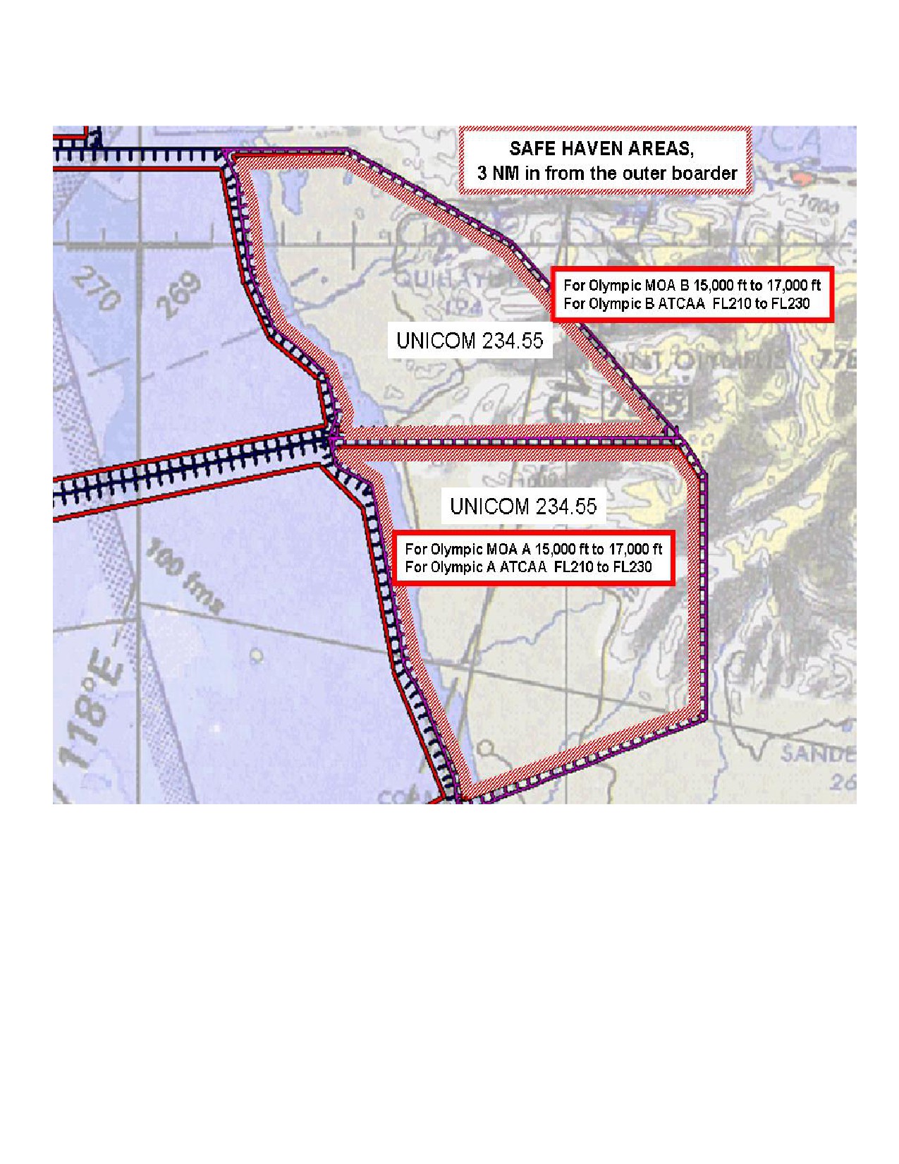
13. UNICOM/SAFE HAVEN procedures are as follows:
a. All aircraft entering a W-237 area will contact Seattle
ARTCC on appropriate frequency (see Table 1 or 5.1.4) for entry
using call sign and appropriate event number. Event numbers
will be assigned by Range Schedules Division at (360) 257-2877.
If multiple aircraft are scheduled for the same event, or co-use
of the area is approved, upon entering W-237 aircraft will check
in via the appropriate UNICOM frequency with call sign and event
number. If no communications with other aircraft can be
established aircraft will proceed to SAFE HAVEN described by a
lateral area extending from the border of the W-237 to 3 NM into
the Warning Area assigned (Illustration 9). Additionally
altitudes for each SAFE HAVEN area are described in Illustration
9. Once established in the SAFE HAVEN area aircraft will
continue to try and contact playmates or co-use aircraft if
still no communications can be established with other aircraft
then aircraft will coordinate exiting W-237 with Seattle ARTCC.
5-11
NASWHIDBEYINST 3770.1E
12 Jul 10
b. When ready to exit W-237 aircraft will coordinate with
Seattle ARTCC on appropriate frequency (see 5.1.4) prior to
leaving assigned area. If multiple aircraft for the same event
are in W-237 the last aircraft departing the Warning Area shall
advise Seattle ARTCC, i.e.
“SEATTLE CENTER PUGET52 EVENT 30001
LAST AIRCRAFT OUT.” Upon reporting last aircraft out, Seattle
ARTCC will close the event number and the airspace will be
deactivated.
5.7 ELECTRONIC COUNTERMEASURES (ECM)
1. The Continental United States ECM Area extends to the outer
boundaries of the coastal ADIZ or a perimeter 150 NM seaward
from the coastal states, whichever is farther out, except where
this infringes on territorial limits of other nations/states.
2. Procedures for conducting ECM, including method of request
and required limitations, are set forth in OPNAVINST 3430.9
(series), AFR 55-44, and applicable COMVAQWINGPAC instructions.
3. West-to-east (towards coastline) ECM runs should not be made
due to potential interference with FAA Radars/NAVAIDS.
4. In addition, use of chaff requires coordination with Western
Air Defense Sector DQM/AST; telephone DSN 382-4342; COMM (253)
982-4342.
5.8 CANADIAN MARITIME PACIFIC (MARPAC) COORDINATION
1. Coordination with Canadian MARPAC Headquarters at Esquimalt
Naval Base, Victoria, B.C., is recommended for any operations
within the Canadian ADIZ.
2. PLAD: MARPACHQ ESQUIMALT CAN
3. Telephone: DSN 319-255-2415/2715; COMM (250) 363-2425/2715.
5.9 HELICOPTER SERVICES. Helicopter services in the PACNORWEST
TRCM OPAREAS are limited. Units desiring services shall submit
requests to NAS WHIDBEY ISLAND WA//N3/N331//, info COMNAVAIRPAC
SAN DIEGO CA//N3/N7// and COMNAVREGNW SEATTLE WA//N3/N00P// for
validation and approval 14 days prior to desired services.
5.10 POST OVERHAUL REQUIREMENTS. Surface units completing an
availability/overhaul at Puget Sound Naval Shipyard (PSNS) shall
coordinate airspace requirements/aircraft services with the PSNS
Combat Systems Branch (Code 290) at DSN 439-7106, COMM (360)
476-7106 for aircraft tracking, CIWS tracking and Link 4/11
testing events.
5-12
NASWHIDBEYINST 3770.1E
12 Jul 10
5.11 SHIP - SHORE COMMUNICATIONS. Dedicated (continuously
guarded) HF assets are not available at NAS Whidbey Island. One
method of establishing communication is via the HF Global
system. This system provides HF radio communications for
passing command and control information. The system/individual
stations are not dedicated to any service, command or activity,
but support authorized users on a traffic precedence basis.
McClellan AFB, CA is the nearest Global station; frequencies are
listed in the DOD FLIP Flight Information Handbook (FIH). Call
sign is McClellan Airways. Facilities for providing phone patch
service are available through all Global stations. Phone patch
service is expedited if destination DSN or commercial phone
numbers are provided at the time of request. The NAS Whidbey
Island ODO can be reached at DSN 820-2681/2682 or COMM (360)
257-2681/2682.
5-13
NASWHIDBEYINST 3770.1E
12 Jul 10
THIS PAGE INTENTIONALLY LEFT BLANK
5-14
NASWHIDBEYINST 3770.1E
12 Jul 10
CHAPTER 6
MILITARY TRAINING ROUTES (MTRs)
6.1 GENERAL
1. NAS Whidbey Island MTRs accommodate high speed, low level
tactical training in excess of 250 KIAS. Operations shall be
conducted at the minimum airspeed compatible with the intent of
the mission. Specific route information is contained in the
FLIP AP/1 B (Military Training Routes).
2. NAS Whidbey Island is the scheduling activity for the
following Military Training Routes.
Military Training Routes
VR-1350
IR-341
VR-1351
IR-342
VR-1352
IR-343
VR-1353
IR-344
VR-1354
IR-346
VR-1355
IR-348
Table 2
NOTE
AR-626 and AR-717A refueling routes are contained
within existing SUA.
Refer to FLIP AP-1 for
coordinates.
Routes are scheduled concurrently with
associated SUA.
NOTE
Units
may
schedule
IR-348
without
concurrently
scheduling the Okanogan and Roosevelt MOAs.
Altitude
restrictions apply and approval is required from NAS
Whidbey Island Range Schedules Division.
3. Routes shall not be used unless scheduled with NAS Whidbey
Island Range Schedules Division. VRs are scheduled at 10-minute
intervals (H + 00, H + 10, H + 20, H + 30, H + 40, H + 50); and
IRs are scheduled at 20-minute intervals (H + 00, H + 20, H + 40).
If alternate entry/exit points are desired, they must be
scheduled. Refer to Chapter 2 paragraph 2.4.2 for additional
scheduling procedures.
4. All routes are one way. Flight operations conducted along
these routes or segments of these routes shall conform to the
direction of traffic flow indicated in the route description.
6-1
NASWHIDBEYINST 3770.1E
12 Jul 10
5. FAIROPS Stereo Flight Plans have been developed for NAS
Whidbey Island-based units to incorporate IR/VR routes into the
local flight plan system. Refer to reference (e).
6.1.1 Preflight Planning. Low-level flying requires extensive
preflight planning to ensure flight safety and maximum training
from each sortie. Familiarity with FLIP AP/1 B and temporary
route advisories is essential.
6.1.2 Operating Procedures
1. Unless otherwise delineated in a route's special operating
procedures, avoid charted, uncontrolled airports by 3 NM or
below 1,500 feet AGL when practicable.
2. Avoid Class B, C, and D, airspace and Minimize disturbance
to persons and property on the ground.
3. All "IR" operations shall be conducted on IFR flight plans.
4. Flight Plan requirements for VR route use:
a. Pilots departing on IFR clearances to fly VRs are
required to file to the fix/radial/distance of their
entry/alternate entry point of the route.
b. Pilots transitioning to IFR upon exiting the VR are
required to have an IFR flight plan on file with the
appropriate fix/radial/distance of their exit point.
NOTE
FAIROPS
Stereo
type
flight
plans
provide
this
operational benefit for NAS Whidbey Island units.
5. Operations on VR routes shall be flown only when the ceiling
is at or above 3000 feet AGL and Flight visibility is 5 statute
miles or greater.
6. All route entries are authorized at published entry/
alternate entry points only. Specific entry times for MTRs are
required to provide safe separation from other Whidbey Island-
scheduled routes. MTR schedules are provided to general/
agriculture aviation interests and are predicated on adherence
to scheduled entry times. Aircraft shall not enter these routes
at any time other than those obtained from NAS Whidbey Island
Range Schedules Division. Entry times will be adhered to within
plus or minus 3 minutes for VRs and plus or minus 5 minutes for
IRs.
6-2
NASWHIDBEYINST 3770.1E
12 Jul 10
CHAPTER 7
CVN OPERATING PROCEDURES
7.1 GENERAL. To standardize procedures for PACNORWEST TRCM CVN
air and surface operations, this chapter outlines procedures
that shall be utilized when conducting flight operations within
the W-237 complex, CYA102, CYR109 and Strait of Juan De Fuca.
The following procedures have been coordinated with the FAA and
are designed to reduce the disruption of CVN training while
providing a safe flying environment for both military and civil
air traffic. CVN operations, which involve flights to shore
stations, are to be conducted per appropriate air traffic
control directives and procedures outlined herein to preclude
air traffic control problems with the FAA, military ATC
Facilities and the WADS. Adherence to these procedures will
alleviate many potential problem areas, enhance training, and
provide the following:
1. Standardization of flight information messages for relay of
flight plan information, ADIZ penetration coordination, Altitude
Reservation Airspace (ALTRV) usage, and ATCAA/warning area/
restricted area scheduling and usage.
2. Communications with shore facilities, surface/air platforms,
WADS and FAA Seattle ARTCC.
3. Adequate lead-times for altitude/airspace reservations.
4. Timely clearance for aircraft entering the National Airspace
System, Class B and C airspace, warning areas, ATCAA, or ALTRV.
7.2 COORDINATION
7.2.1 Planning Conference. Prior to any underway period
involving flight operations, a face-to-face meeting shall be
held at least 3 working days in advance to discuss operations.
Air Operations, Strike Operations, and air wing personnel will
meet with NAS Whidbey Island Operations Department to discuss
the following items of interest:
1. Planned PACNORWEST TRCM exercises and flight operations.
2. Coordinate OPAREA/airspace planning briefs.
3. Confirm OPAREA reservations, obtain ALTRV/MOAs/ATCAAs as
required.
4. Use of Canadian airspace.
7-1
NASWHIDBEYINST 3770.1E
12 Jul 10
5. IFF assignments.
6. Operations penetrating the National Airspace System/Flight
Planning.
7. Flight operations in the Strait of Juan De Fuca.
8. Communications/coordination.
9. Unusual hours of operation.
10. Other items of interest.
7.2.2 ATC briefs/liaison Shipriders. Upon request, NAS Whidbey
Island will furnish orientation teams capable of briefing
AIROPS/CATCC/AIRWING personnel on OPAREA procedures and
interfacing with the National Airspace System. In addition, ATC
personnel are available to serve as onboard liaison during at-
sea periods. Requests for orientation briefs/ship riders can be
arranged by contacting ATC (Code N33) at DSN 820-2132, COMM
(360) 257-2132.
7.3 PRE-SAIL COORDINATION MESSAGES
7.3.1 Summary of Operations. No less than 48 hours prior to
commencement of AIROPS, the carrier shall send a summary of
intended air operations by message to NAS Whidbey Island,
concerned FAA facilities, NORAD, Canadian military/ATC and other
appropriate facilities. Anticipated AIROPS for the entire
period shall be listed. This message does not rescind or
supersede airspace request procedures found in other sections of
this manual, or replace divert alert/Notice of Intent/IFF
messages as required by higher authority.
The following example is provided:
FM:
(CVN)
TO:
NAS WHIDBEY ISLAND WA/N3/N33/N331//
FAA SEATTLE ARTCC AUBURN SEATTLE WA/MOS//
WESTERN AIR DEF SX MCCHORD AFB WA/IS/SOCC/DOOS//
MOC ESQUIMALT//N36-1//
WOC COMOX//
INFO: (Other addees as required)
(UNCLAS/CONFIDENTIAL)//N03120//
SUBJ: SUMMARY OF INTENDED AIR OPERATION
MSGID: GENADMIN/(ORIGINATOR)//
7-2
NASWHIDBEYINST 3770.1E
12 Jul 10
RMKS: 1. Read in four (4) columns:
DATE
TIME
EVENT
OPAREA
21 FEB
1830-2100Z
CYCLIC OPS
W-237 A,B
22 FEB
2000-2200Z
CQ
SOJDF
24 FEB
1900-2100Z
HELO OPS
CYA-102
7.3.2 Divert Alerts. Divert Alert requests shall be submitted
per higher authority instructions. NAS Whidbey Island is a 24-
hour airfield; however, additional personnel are required to
support CVN divert/bingo operations. Accuracy of divert alert
periods is essential to ensure support of CVN contingencies.
7.3.3 OPAREA Requests. Users shall submit OPAREA requirements
to NAS Whidbey Island Range Schedules Division per chapter 2 of
this manual. Due to rapidly changing sea conditions, short fuse
requests or changes will be accepted by phone/e-mail or airborne
relay.
7.3.4 ALTRV Requests. CVNs shall submit ALTRV requirements for
domestic airspace to FAA CARF Washington DC, info FAA SEATTLE
ARTCC AUBURN WA/MOS// and WESTERN AIR DEF SX MCCHORD AFB
WA//IS/SOCC/DOOS//. Requests shall be made per Special Military
Operations FAA Handbook 7610.4, part 3 (OPNAVINST 3722.33) no
less than 6 days prior to COMEX of flight OPS to ensure approval
and NOTAM promulgation to users of Special Use Airspace.
7.3.5 IFF Requests. A request for IFF code assignment shall be
received NLT 3 days prior to at-sea period. In lieu of message,
IFF codes may be assigned at the pre-sail conference.
7.4 FLIGHT PLANNING
7.4.1 OPAREA Modifications. To ensure airspace availability,
users shall submit OPAREA modification requests no later than
1500L the day prior. Submit ALTRV/ATCAA modification requests
as soon as practicable to ensure ARTCC ability to coordinate
requested modification. Verification of receipt of critical
messages (i.e. short notice OPAREA modifications, change of
flight operations, incident, mishaps, etc.) by phone
communications, when practical, is recommended.
7.4.2 Daily Air Plan. To permit NAS Whidbey Island and other
appropriate agencies to prepare for upcoming flight operations,
the CVN shall include NAS Whidbey Island and other appropriate
agencies as an addee on the daily Air Plan.
7-3
NASWHIDBEYINST 3770.1E
12 Jul 10
7.4.3 Flight Information Messages. In order to recognize and
identify naval aircraft operating in the Pacific Coast ADIZ,
CADIZ, flight information (flight advisories, launch advisories,
flight plans) shall be passed to NORAD (WESTERN AIR DEF SX
MCCHORD AFB WA) include NAS Whidbey Island, FAA Seattle ARTCC
and cognizant area commanders as info addees.
7.4.4 Flight Plans. Navy and FAA facilities must be kept informed
of all aircraft that will enter the National Airspace System. To
ensure timely filing, flight plans should be sent to NAS Whidbey
Island listing all action addees above. Every effort should be
made to use Stereo Routes contained in Appendix 1.
1. A minimum lead-time of 2 hours is required if filing Stereo
Routes, and 4 hours for non-stereo routes. With ample
notification via phone relay or relay from airborne platform,
unscheduled flights will be handled on a case-by-case basis.
2. Once filed, flight plans are valid for 30 minutes prior to
and 2 hours after proposed launch time.
3. Aircraft may enter the National Airspace System as singles,
sections, or waves, but individual call signs/squawks (although
in standby) are required for each aircraft in the event of
emergencies, IMC, or separation of the flight. Filed call signs
will be retained throughout the flight. Use of other than filed
call signs for the mission can cause confusion with ATC agencies
and possibly result in a delay in obtaining clearance or
assistance, use of tactical call signs is permitted.
4. NAS Whidbey Island Base Operations will file all CVN flight
plans.
7.4.5 Overhead Messages. To ensure aircrews receive CVN
overhead times, include NAS WHIDBEY ISLAND WA/N3/N33/N331// as
an addee on all overhead messages. A copy will be retained at
the NAS Whidbey Island ODO desk for reference.
7.5 AT-SEA COORDINATION. Pre-sail coordination is the best
method to articulate user requirements. However, it is
understood that various events can and will effect planned
evolutions. At-sea, to ensure receipt of special requests,
airspace coordination, or flight plans, message traffic with
proper lead times is the preferred method of communication.
When time precludes use of message traffic, phone conversation
or airborne relay is an acceptable substitute. Use of e-mail
messages is encouraged; however, e-mail notification cannot be
considered complete unless response e-mail is received from NAS
Whidbey Island confirming the action or responding to a request.
Some examples of at-sea coordination:
7-4
NASWHIDBEYINST 3770.1E
12 Jul 10
1. Notification of secured flight operations (cold deck
notification required)
2. Short fused flight plans.
3. Warning area airspace changes.
4. Coordination to move to Strait of Juan De Fuca due to W-237
weather/sea states.
5. Extensions of divert alert periods.
7.6 COMMUNICATIONS
7.6.1 Landline Communications
1. When required for immediate coordination, NAS Whidbey Island
phone numbers listed in Table 3 shall be used:
NAS WHIDBEY POCs
Agency
Number
Operating Hours
ATC Facility
(360) 257-2887
24 Hours
Range Schedules
(360) 257-2877
0700-1600
Range Schedules
(360) 257-1283
FAX
OPS Duty Officer
(360) 257-2681
24 Hours
Flight Planning
(360) 257-1601
24 hours
NAS OPS
(360) 257-2120
0730-1600
Table 3
(Phone numbers are COMM and DSN prefix is 820)
2. Should a need arise to contact FAA Seattle ARTCC; the phone
numbers in Table 4 should be used.
FAA SEATTLE ARTCC POCs
Agency
Number
Operating Hours
Military Ops
(253) 351-3523
0700-2300
TRFC Mgmt
(253) 351-3520
24 hours
Area Sup
(253) 351-3505
24 hours
Table 4
7.6.2 Ship-to-Shore Communications. Ship-to-shore radio
communications are extremely limited and may only be effective
when the CVN is in local waters/Strait of Juan De Fuca and
within 15/20 miles of NAS Whidbey Island. There are no ship-to-
7-5
NASWHIDBEYINST 3770.1E
12 Jul 10
shore communications in the W-237 complex. Radio frequencies
are contained in Table 5.
NAS WHIDBEY ISLAND RADIO FREQUENCIES
AGENCY
FREQ (UHF/VHF)
Approach CTL (CVN Sector)
266.8 or L/L
Approach Control
285.65/118.2
Control Tower
340.2/127.9
Base OPS/ODO
350.0
Table 5
7.6.3 Air-to-Ground Communications. Aircraft operating within
100 miles of NAS Whidbey Island should experience good air-
ground communications with NAS Whidbey Island ATC on the
frequencies listed in Table 5. Aircraft operating in the W-237
complex should be able to maintain adequate communications with
FAA SEATTLE ARTCC (319.2/125.1), except at lower altitudes.
Flight leader or communications relay aircraft shall contact
SEATTLE ARTCC at least 5 minutes prior to obtain clearances and
to alleviate any enroute delays. This will also permit flight
participants to continue with their mission while the clearance
is being obtained. All aircraft operating within the W-237
complex are required to contact Seattle Center for entry/exit
approval. This may be accomplished by individual aircraft
commanders or through the designated communications aircraft.
7.7 BINGO/DIVERTS TO SHORE FACILITIES
7.7.1 Bingo. A bingo aircraft inbound to a shore facility is an
emergency and will be assimilated into the National Airspace
System as expeditiously as possible. However, FAA publications
do not define the term bingo as an emergency, nor is it
indicative to FAA personnel that an aircraft is experiencing
difficulties. To ensure priority handling, aircrew shall
declare an emergency, stating the nature of the emergency, i.e.,
"EMERGENCY LOW FUEL," "PORT ENGINE OUT," etc. Once an emergency
has been declared, if not already selected, IFF transponder will
be set to the appropriate emergency code. Remain on that code
until directed by ATC.
WARNING
Aircraft unable to contact ATC shall not enter
Positive Controlled Airspace unless squawking the
appropriate emergency code.
7-6
NASWHIDBEYINST 3770.1E
12 Jul 10
7.7.2 Diverts
1. An aircraft inbound to a shore facility without an emergency
is simply a divert. No special handling should be expected by
the divert aircraft. If fuel state becomes a concern, aircrew
shall state "Minimum Fuel" to the ATC facility when the aircraft
reaches minimum fuel state as defined by NATOPS.
2. When diverts involve multiple aircraft, advance announcement
of the divert to the controlling agency by the lead aircraft (or
airborne relay) will greatly assist ATC and reduce aircraft
delays. At a minimum, the number of aircraft inbound and
destination should be provided.
7.8 CONDUCT OF FLIGHT
7.8.1 W-237 Complex Operations. All flights operating within
the W-237 complex are required to remain in "due regard" status
per OPNAVINST 3770.4 (series) until radar contact is established
by FAA Center.
7.8.2 Strait of Juan de Fuca/Puget Sound Operations. The Strait
of Juan de Fuca and the Puget Sound are not SUA, and as such,
Federal Air Regulations and standard air traffic control
procedures are applicable. "Due Regard" is not authorized
within the Puget Sound/Strait of Juan de Fuca. All aircraft,
not on an IFR flight plan, shall follow standard VFR procedures.
Specific procedures for operating within this airspace are
contained in Paragraph 7.9.
7.9 STRAIT OF JUAN DE FUCA (SOJDF) CARRIER OPERATIONS
7.9.1 GENERAL SPECIAL USE AIRSPACE. Specifically a warning area
is designated as an operational area for potentially hazardous
military air and surface activity. The SOJDF, however, has not
been designated as SUA, and safety precautions normally
exercised in association for flight within warning areas are not
present. Therefore, to enhance safety with the SOJDF, local
procedures have been developed to permit CVNs to conduct limited
flight operations in close proximity to civilian users.
7.9.2 CVN use of SOJDF. CVNs are strongly encouraged to use W-
237 complex for flight operations. When missions or W-237
weather/sea conditions restrict use of the Warning Areas, the
SOJDF may be used for limited flight operations. Scheduling and
use of SOJDF is controlled and must be pre-coordinated at a pre-
sail conference. The following restrictions apply:
1. Day time, Case 1 only.
7-7
NASWHIDBEYINST 3770.1E
12 Jul 10
2. Limit six aircraft in CVN pattern.
3. All aircraft must monitor Whidbey Approach Control Frequency
in addition to CVN L/L.
4. All aircraft must be on discrete beacon codes.
5. Minimum of 2 1/2 hour lead-time is required for NOTAM
broadcast.
6. When able, a radio or phone communication link shall be
maintained between CVN CATCC and Whidbey Approach.
7. CVN is responsible for scheduling Canadian OPAREAS.
8. Participating aircrew shall attend brief on SOJDF
operations.
7.9.3 SOJDF Airspace for CVN Use
1. A portion of airspace within the SOJDF has been locally
designated for CVN flight operations (Illustration 6). This
airspace is of sufficient size for both aircraft operations and
surface navigation purposes and should be used by CVNs to the
maximum extent practical due to added safety benefits,
specifically, ship-to-shore/air-to-ground communications and ATC
RADAR coverage. In this designated area, all CVN aircraft will
be provided RADAR traffic advisories by NAS Whidbey Approach
Control on a discrete frequency or on the CVN land launch
button.
2. Aircraft operations in the Strait of Juan De Fuca involve
many different types of aircraft from seaplanes to air carriers.
A high mid-air collision potential exists. Additionally, many
of the air carrier aircraft that transit the SOJDF each day are
equipped with TCAS equipment. A TCAS incident can be avoided
when both military and civil aircraft are receiving traffic
advisories from a controlling agency. Use of the designated
OPAREA and compliance with local operating procedures are key to
deconflicting civil and military traffic that operate within the
SOJDF.
CAUTION
High
intensity
civil
non-participating
military
VFR/IFR traffic will be encountered in the Puget Sound
and Strait of Juan De Fuca. Military aircrew must be
alert for both controlled and uncontrolled aircraft.
7-8
NASWHIDBEYINST 3770.1E
12 Jul 10
STRAIT OF JUAN DE FUCA CVN OPAREA
48 17'.3N/122 43'.7W
48 10'.0N/122 51'.7W
48 12'.6N/123 14'.5W
48 12'.0N/123 20'.0W
48 20'.0N/123 22'.0W
48 25'.5N/123 07'.0W
48 22'.4N/122 46'.6W
7-9
NASWHIDBEYINST 3770.1E
12 Jul 10
THIS PAGE INTENTIONALLY LEFT BLANK
7-10
NASWHIDBEYINST 3770.1E
12 Jul 10
CHAPTER 8
NAVAL WEAPONS SYSTEM TRAINING FACILITY BOARDMAN, OREGON
8.1 DESCRIPTION. Illustration (3). The Boardman Naval Weapons
System Training Facility (NWSTF) complex consists of R-5701,
R-5706, Boardman MOA, and ATCAA. This complex is used for basic
air maneuvering, electronic threat simulations, air-to-ground
weapons delivery, small arms, and various ground training
exercises. Services provided by NWSTF are very limited. There
are no Range Clearance personnel, moving targets, or any type of
scoring systems available.
8.1.1 Operating Hours. Monday through Friday, 0730 - 1600.
Air-to-ground or mobile emitter events will normally be
scheduled during these hours. Air-to-ground or emitter events
outside these times will be coordinated via the NAS Whidbey
Island Operations Officer at least 72 hours in advance. This
does NOT apply to normal operations in the airspace above the
Boardman range.
8.1.2 Boardman MOA and ATCAA Boundaries
Boundaries:
Beginning at:
45 52’59N/119 31’04W to
45 46’49N/119 31’04W to
45 47’44N/119 23’29W to
45 46’59N/119 22’29W to
45 45’09N/119 22’34W to
45 43’29N/119 23’54W to
45 42’14N/119 25’04W to
45 39’59N/119 27’14W to
45 36’09N/119 45’44W to
45 38’59N/120 09’04W to
45 45’29N/120 09’04W
proceed along the south shore of the Columbia river to
45 50’49N/119 48/44W to
45 50’49N/119 45’04W to
45 50’19N/119 45’04W to
45 50’19N/119 42/34W to
45 50’59N/119 42’34W then
along the south shore of the Columbia River to
45 51’09N/119 40’04W to
the point of beginning, excluding that airspace within a 5 NM
radius of a point located at 45 43’35N/119 41’07W; and excluding
that airspace within R5701 and R5706 when active.
8-1
NASWHIDBEYINST 3770.1E
12 Jul 10
MOA:
4,000 feet MSL to, but not including, FL180.
ATCAA: FL180 to, and including, FL200.
8.1.3 Boardman Restricted Area 5701 area (a).
BOARDMAN, OR to FL200
Cir rad 5 NM cntr on N45°43'35.00" W119°41'07.00
Description as per the AP/1B
8.1.4 Boardman Restricted Area 5701 area (b).
BOARDMAN, OR to 10000 feet MSL
N45°46'19.00" W119°35'09.00" to
N45°47'00.00" W119°31'30.00" to
N45°42'00.00" W119°30'45.00" to
N45°41'28.00" W119°34'39.00" then
CCW along the arc of a cir rad 5 NM cntr on N45°43'35.00"
W119°41'07.00" to beginning. Description as per the AP/1B
8.1.5 Boardman Restricted Area 5701 area (c).
BOARDMAN, OR to 6000 feet MSL
N45°47'00.00" W119°31'30.00" to
N45°47'30.00" W119°21'30.00" to
N45°45'45.00" W119°21'30.00" 1 NM W of and parl to Butter Creek
to N45°42'00.00" W119°30'45.00" to beginning. Description as
per the AP/1B
8.1.6 Boardman Restricted Area 5701 area (d).
BOARDMAN, OR to 10000 feet MSL
N45°46'47.00" W119°46'37.00" then
CCW along the arc of a cir rad 5 NM cntr on N45°43'35.00"
W119°41'07.00" to
N45°38'53.00" W119°43'34.00" to
N45°37'15.00" W119°46'45.00" to
N45°41'30.00" W119°51'00.00" to
N45°47'00.00" W119°51'00.00" to beginning. Description as per
the AP/1B
8.1.7 Boardman Restricted Area 5701 area (e).
BOARDMAN, OR to 6000 feet MSL
N45°47'00.00" W119°51'00.00" to
N45°41'30.00" W119°51'00.00" to
N45°37'15.00" W119°46'45.00" to
N45°36'15.00" W119°49'00.00" to
N45°36'30.00" W119°51'00.00" to
N45°40'15.00" W119°55'00.00" to
N45°41'00.00" W119°54'30.00" to
N45°41'00.00" W120°02'30.00" to
N45°47'00.00" W120°02'30.00" to beginning. Description as per
the AP/1B
8-2
NASWHIDBEYINST 3770.1E
12 Jul 10
8.1.8 Boardman Restricted Area 5706
BOARDMAN, OR 3500 feet MSL to 10000 feet MSL
N45°40'33.00" W120°02'32.00" to
N45°40'39.00" W120°09'04.00" to
N45°45'29.00" W120°09'04.00" thence E along the S shore of the
Columbia River to
N45°51'09.00" W119°40'04.00" to
N45°52'59.00" W119°31'04.00" to
N45°46'34.00" W119°31'04.00" to
N45°46'12.00" W119°35'02.00" then
CCW along the arc of a cir rad 5 NM cntr on N45°43'35.00"
W119°41'07.00" to
N45°46'35.00" W119°46'50.00" to
N45°46'33.00" W120°02'32.00" to beginning. Description as per
the AP/1B
Altitudes:
3,500 feet MSL to 10,000 feet MSL.
8.2 OPERATING PROCEDURES
8.2.1. General. NWSTF Boardman is currently an uncontrolled
range. The following standard operating procedures will be
adhered to unless other arrangements are made in writing with
the NAS Whidbey Island Operations Officer (i.e., providing your
own qualified range controllers, etc.)
8.2.2. Entering Boardman Range. All aircraft will broadcast in
the blind, intentions, commencing operations, and completing
operations. A reply from Boardman personnel is not required in
order to commence operations, as this is an uncontrolled range.
Visual inspection by the aircraft commander of the range is
required to ensure the range is clear.
Call Sign:
“BOARDMAN RANGE”
UHF:
305.8 MHZ OR Secondary 243.0 MHZ Guard
VHF:
134.1 MHZ OR Secondary 121.5 MHZ Guard
Aircraft shall make “INBOUND” or “IN TARGET HOT” and “OFF SAFE”
transmissions in the blind.
Telephone: COMM (541) 481-2565, FAX 2567
8.2.3. Departing Boardman Range. For IFR flight, aircraft will
obtain IFR clearance directly from Seattle ARTCC:
Call Sign: SEATTLE CENTER
8-3
NASWHIDBEYINST 3770.1E
12 Jul 10
UHF:
269.35 MHZ
VHF:
132.6 MHZ
Telephone: DSN 891-1241 or COMM: (206) 351-3593
For VR Routes, aircraft will enter at scheduled entry time/point
and contact Flight Service:
Call Sign: SEATTLE RADIO or MCMINNVILLE RADIO 255.4 MHZ
8.3 MAIN TARGET. Usable targets are listed in Table (1) with
associated photographs (taken December 2007) for reference.
8.3.1 Target (1). General Description. The main target is a T-60
Tank. There are four concentric circles around the bull at 100,
500, 1000, and 1500 feet. There is a 6000-foot square centered on
the bull. At 650 feet MSL there are two offset reflectors to
support the main bull, Target #2 and Target #3.
8.3.2 Navigation Check Point. Carty Coal Plant, 45 41.608N/119
48.430W, 1352 feet MSL (top of stacks).
8.4 STRAFING PIT. Located south-southwest of the Main Bull at
45 42.545N/119 41.939W. Strafing procedures are:
a. Upon entering Restricted Area R-5701 make a radio call in
the blind to “BOARDMAN RANGE” stating: aircraft call sign,
position relative to intended target (e.g., “entering R-5701, 8 NM
Southwest of Strafe Pit”),altitude (e.g. “Angels X”), number and
type weapons to be released (e.g. “900 Rounds PGU-27 TP & TP-t”)
and number of passes on target including initial clearing pass and
direction of turns for multiple runs (e.g. “5 passes, left
turns”).
b. High and low angle strafing is approved.
c. A “GUNS COLD” initial clearing pass over the strafe pit
will be accomplished to ensure a clear range before commencing
strafing runs.
d. A “BOARDMAN RANGE, [call sign], strafe pit, hot guns”
call will be made in the blind each pass.
e. The “Foul Line” is 2000 feet short of the strafe pit
target.
8-4
NASWHIDBEYINST 3770.1E
12 Jul 10
f. Tracer rounds are authorized between 1 October and 31
May or at other times upon written approval of the NAS Whidbey
Island Operations Officer (e.g. should unit scheduling provide
its own wildfire suppression personnel and equipment onsite
during strafe operations consideration will be made to permit
tracer rounds use outside the normal “low fire danger” season).
Notify “Boardman Range” of “possible wildfire” immediately if it
appears brush near the strafe pit has caught fire.
g. Cease firing any time “[Call Sign], BOARDMAN RANGE,
CEASE FIRE, CEASE FIRE, CEASE FIRE” is called over Boardman
Range frequency or on UHF Guard.
h. Runaway guns procedure is to fly strafe run-in heading
(028’ Magnetic) until ammunition is expended then notify
“BOARDMAN RANGE” with call sign and state “RUNAWAY GUNS.”
i. After the last pass on target call in the blind to
“BOARDMAN RANGE” stating “[call sign], off-target, GUNS COLD,
[number and type munitions expended].”
j. Runs will be made from South to North only (028
magnetic). Runs from the North are not authorized.
Any questions, please call the NAS Whidbey Island Operations
Officer at (360) 257-2120 or Navy Region Northwest Range Support
at (360) 257-3315.
8.5 RANGE PRIORITY. Priority for aircraft will be assigned as
follows:
a. PRI 1: Scheduled Condon IP aircraft for initial run.
b. PRI 2: Scheduled Arlington IP Aircraft for initial run.
c. PRI 3: Regularly scheduled aircraft already established
in the pattern.
d. PRI 4: High Pattern dive-bombing attacks.
e. PRI 5: Aircraft performing test flights.
f. PRI 6: Scheduled windows for other-than-Navy forces.
NOTE
Refer to chapter 2 for scheduling priority
8.6 TYPE EXERCISE/ORDNANCE. Air-to-ground high, intermediate and
low altitude bombing, loft bombing and rockets. MK-76, BDU-48,
8-5
NASWHIDBEYINST 3770.1E
12 Jul 10
LGTRs or other inert ordnance not to exceed 25 pounds may be used
on all targets (with exception of #2 and #3 radar reflectors).
Inert 2.75 FFAR Rockets are authorized on any metal tactical
target. Five-inch practice Zuni rockets or inert ordnance up to
1000 pounds may be expended on the LGB and offset bull. Flares or
other incendiary devices are specifically prohibited. Any items
brought to the Boardman Range must be taken off the range when the
unit departs. This includes, but is not limited to, any HAZMAT,
spent brass or anything else brought aboard the range.
8.7 PATTERNS. Flight profiles will normally adhere to a left
hand pattern or as directed by the flight lead. When more than
one flight is scheduled in the range at the same time, flight
leads must have completed a face-to-face brief to include,
altitude, patterns, and lost sight/abort procedures.
8.8 EXIT PROCEDURES. Unless safety of flight dictates, no
aircraft intending IFR flight shall depart the Boardman Complex
until an ATC clearance is received from Seattle ARTCC. Under
normal circumstances, aircraft should provide Seattle ARTCC at
least 5 minute advance notice of intent to depart. This
provides needed time for flight data processing and coordination
when required.
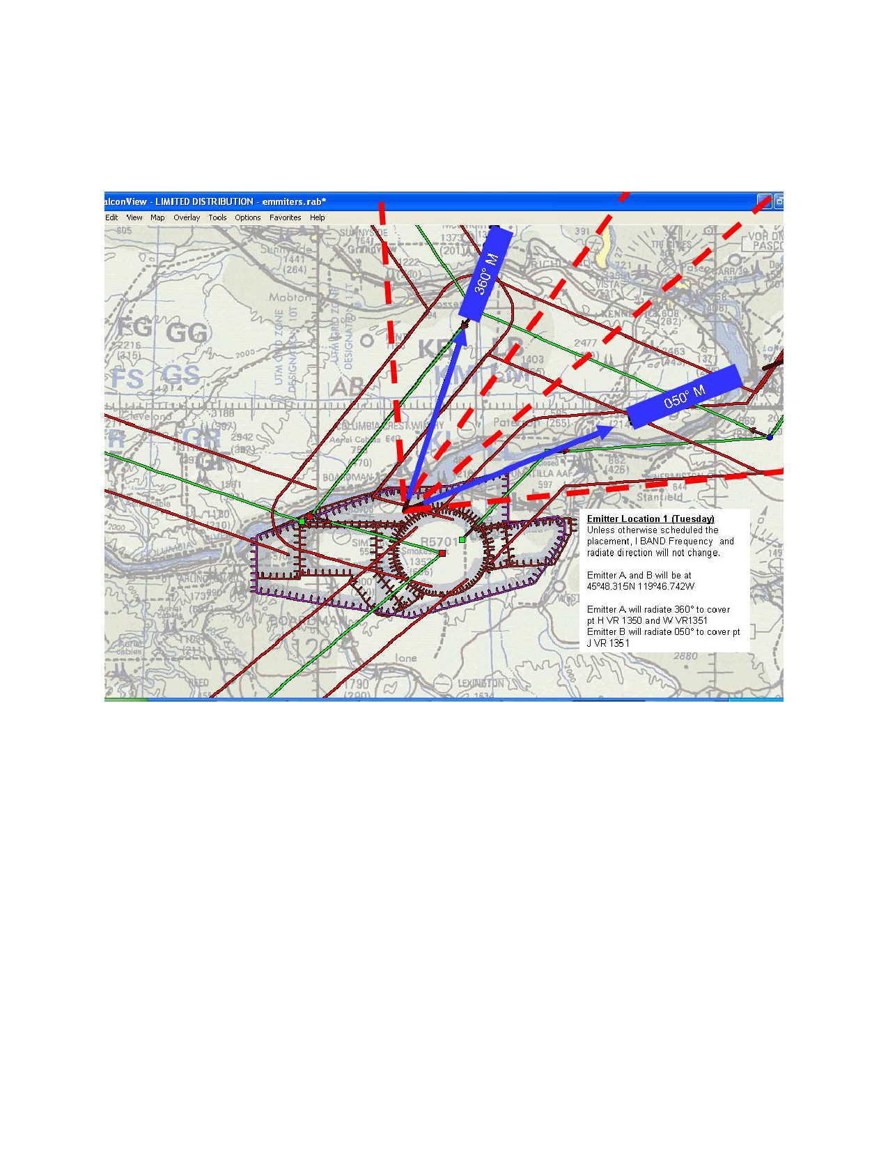
8.9 AN/UPQ-8 (V) THREAT EMITTER SIMULATORS. Two AN/UPQ-8 (V)
Threat Emitter Simulators are available in NWSTF Boardman. They
are designated Emitter Alpha and Emitter Bravo. These two
Emitters radiate in the I BAND frequency spectrum. They are for
basic level training; however, schedule and frequencies can be
modified for more advanced training needs. Operation of these
units is Tuesday through Thursday 0800 to 1600. Any other time
or special training needs will require a minimum of 48 hours,
prior to the training event, scheduling. Unless otherwise
scheduled the Emitters will radiate from the following locations
in the following established directions:
8-6
NASWHIDBEYINST 3770.1E
12 Jul 10
a. Every Tuesday from Location 1 - 45º48.315N 119º46.742W,
Emitter Alpha will radiate 360° and Emitter Bravo will radiate
050°.
8-7

NASWHIDBEYINST 3770.1E
12 Jul 10
b. Every Wednesday from Location 2 - 45º39.542N
119º43.373W, Emitter Alpha will radiate 350° and Emitter Bravo
will radiate 040°.
8-8

NASWHIDBEYINST 3770.1E
12 Jul 10
c. Every Thursday from Location 3 - 45°46.208N 119º 41.161W,
Emitter Alpha will radiate 345° and Emitter Bravo will radiate
045°.
8-9
NASWHIDBEYINST 3770.1E
12 Jul 10
THIS PAGE INTENTIONALLY LEFT BLANK
8-10

NASWHIDBEYINST 3770.1E
12 Jul 10
B 003 AGL
NOT TO
INCLUDE
-090
A 090
-NOT TO
B 003 AGL -
INCLUDE
NOT INCLUDE
A 090
FL180
090
-NOT TO A
A 090-NOT TO
A 090-
INCLUDE
INCLUDE FL180
NOT TO
C 003
A/B
FL180
INCLUDE
AGL
FL180
NOT TO
INCLUDE
-090
A 090
-NOT TO
INCLUDE
FL180
OKANOGAN AND ROOSEVELT MOAs
ATCAAs FL180 to, but not including, FL240
MOLSON AND REPUBLIC
ATCAAs
FL240 to FL500
MOLSON SOUTH LOW
ATCAA
FL240 to, but not including, FL290
MOLSON SOUTH HIGH
ATCAA
FL290 to FL500
(5 DAYS ADVANCE COORDINATION REQUIRED)
FOR SCHEDULING MOLSON SOUTH HIGH)
ILLUSTRATION 1

NASWHIDBEYINST 3770.1E
12 Jul 10
OLYMPIC MOAS, W-237 AND OLYMPIC COAST
NATIONAL MARINE SANCTUARY
48°21’02”N
48°29’37”N
130°00’00”W
125°09’01
48°20’00”N
128°00’00”W
W-237E
48°08’59”N
SFC to
127°54’44”W
FL 270
48°08’59”N
125°05’00”W
48°08’59”N
125°56’05”W
48°08’59”N
48°08’59”N
125°56’05”W
124°48’05”W
W-237B
Olympic B 6000 to
Low SFC to but
but not including
not including FL230
FL180 excluding
below 1200 AGL.
High FL230 to but
N47°41'29.00"
not including FL500
ATCAA FL180-FL350
W124°33'05.00
W-237H
W-237F
"
SFC to
SFC to
FL 270
UNLIMITED
N47°31'59.00"
W-237C
W125°41'05.00
Olympic A 6000 to
SFC to
but not including
UNLIMITED
FL180 excluding
W-237A
below 1200 AGL.
Low SFC to but
ATCAA FL180-FL350
not including FL230
High FL230 to but
not including FL500
47°00’00”N
N47°05'59.00"
129°00’00”W
47°00’00”N
W124°14'53.00
127°22’26”W
47°00’00”N
47°00’00”N
47°00’29”N
126°15’00”W
"
125°28’03”W
124°30’05”W
46°53’24”N
46°49’59”N
125°06’47”W
125°24’08”
OLYMPIC COAST
W-237G
SFC to
NATIONAL MARINE SANCTUARY
W-237D
W-237J
UNLIMITED
SFC to
SFC to
UNLIMITED
FL 270
46°32’00”N
125°18’00”W
46°06’00”N
126°15’00”W
45°50’00”N
128°10’00”W
45°48’35”N
126°50’49”W
ILLUSTRATION 2

NASWHIDBEYINST 3770.1E
12 Jul 10
Boardman MOA/ATCAA/R5701/R5706
BOARDMAN
MOA
4000 TO BUT NOT INCLUDING FL 180
ATCAA
FL180 - FL200
R5706
3500
TO
10000
R5701
R5706
R5701
B
TO 6000
R5701
3500
TO 6000
E
TO
C
D
SFC-FL200
10000
A
R5701
TO 10000
ILLUSTRATION 3

NASWHIDBEYINST 3770.1E
12 Jul 10
DARRINGTON
48o21’00”N
22o44’00”W
ILLUSTRATION 4

NASWHIDBEYINST 3770.1E
12 Jul 10
ILLUSTRATION 5

NASWHIDBEYINST 3770.1E
12 Jul 10
CVNOA
ILLUSTRATION 6

NASWHIDBEYINST 3770.1E
12 Jul 10
ILLUSTRATION 7

NASWHIDBEYINST 3770.1E
12 Jul 10
ILLUSTRATION 8
NASWHIDBEYINST 3770.1E
12 Jul 10
TARGET IDENTIFICATION
LOCATION
LAT/LONG
TGT
1 MAIN BULL
CENTER
45
43.589N/119 41.124W
TGT
2 REFLECTORS (DO NOT HIT)
CENTER
45
44.248N/119 41.125W
TGT
3 REFLECTORS (DO NOT HIT)
CENTER
45
42.124N/119 41.929W
TGT
4 AAA GUN
CENTER
45
43.931N/119 41.029W
TGT
5 AAA GUN
CENTER
45
43.873N/119 41.029W
TGT
6 AAA GUN
CENTER
45
43.826N/119 40.973W
TGT
7 SAM CONTROL VAN
CENTER
45
43.801N/119 41.177W
TGT
8 SAMS
CENTER
45
43.912N/119 41.497W
TGT
9 SAMS
CENTER
45
43.860N/119 41.561W
TGT
10 SAMS
CENTER
45
43.787N/119.41.617W
TGT
11 SAMS
CENTER
45
43.700N/119 41.640W
TGT
12 SAMS
CENTER
45
43.267N/119 41.328W
TGT
13 SAMS
CENTER
45
43.170N/119 41.366W
TGT
14 M-60 TANK
CENTER
45
42.931N/119 41.425W
TGT
15 M-60 TANK
CENTER
45
43.072N/119 41.153W
TGT
16 MOBILE SCUD
CENTER
45
43.114N/119 41.244W
TGT
17 MOBILE SCUD
CENTER
45
43.058N/119 41.241W
TGT
18 VAN/REFLECTORS
CENTER
45
43.488N/119 40.804W
TGT
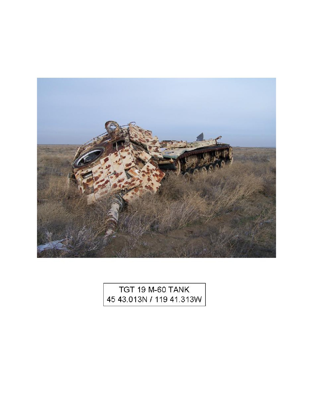
19 M-60 TANK
CENTER
45
43.013N/119 41.313W
TGT
20 M-60 TANK
CENTER
45
42.993N/119 41.337W
TGT
21 TRUCK
CENTER
45
43.010N/119 41.436W
TGT
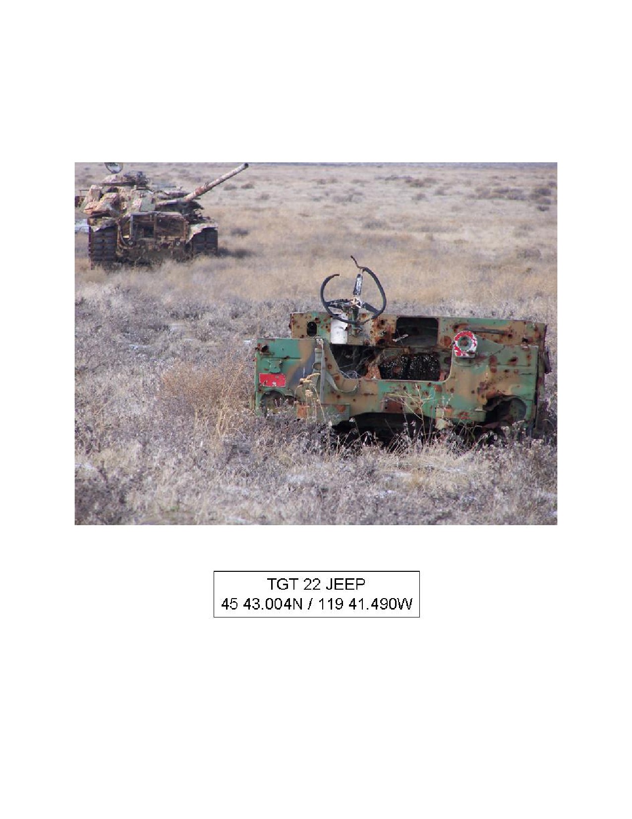
22 JEEP
CENTER
45
43.004N/119 41.490W
TGT
23 M-60 TANK
CENTER
45
43.003N/119 41.583W
TGT
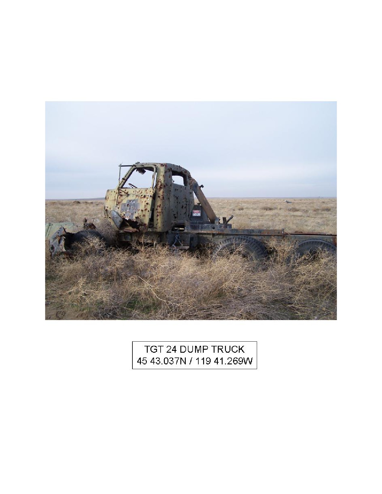
24 DUMP TRUCK
CENTER
45
43.037N/119 41.269W
TGT
25 LGB (BUS)
OFFSET
45
43.476N/119 41.523W
TGT
26 OFFSET BULL
OFFSET
45
43.353N/119 41.455W
Table (1)
2

NASWHIDBEYINST 3770.1E
12 Jul 10
3

NASWHIDBEYINST 3770.1E
12 Jul 10
4

NASWHIDBEYINST 3770.1E
12 Jul 10
5
NASWHIDBEYINST 3770.1E
12 Jul 10
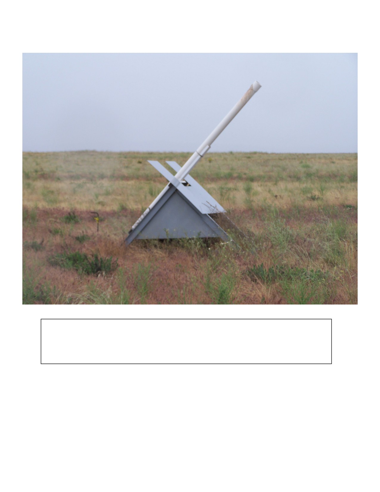
TGT 4 AAA GUN
45 43.931N/119 41.029W
TGT 5 AAA GUN
45 43.873N/119 41.029W
TGT 6 AAA GUN
45 43.826N/119 40.973W
6

NASWHIDBEYINST 3770.1E
12 Jul 10
7
NASWHIDBEYINST 3770.1E
12 Jul 10
TGT 8 SAMS
45 43.912N/119 41.497W
TGT 9 SAMS
45 43.860N/119 41.561W
TGT 10 SAMS
45 43.787N/119 41.617W
8

NASWHIDBEYINST 3770.1E
12 Jul 10
9
NASWHIDBEYINST 3770.1E
12 Jul 10
TGT 12 SAMS
45 43.267N/119 41.328W
TGT 13 SAMS
45 43.170N/119 41.366W
10

NASWHIDBEYINST 3770.1E
12 Jul 10
11

NASWHIDBEYINST 3770.1E
12 Jul 10
12

NASWHIDBEYINST 3770.1E
12 Jul 10
13

NASWHIDBEYINST 3770.1E
12 Jul 10
14

NASWHIDBEYINST 3770.1E
12 Jul 10
15
NASWHIDBEYINST 3770.1E
12 Jul 10
16

NASWHIDBEYINST 3770.1E
12 Jul 10
17

NASWHIDBEYINST 3770.1E
12 Jul 10
18
NASWHIDBEYINST 3770.1E
12 Jul 10
19

NASWHIDBEYINST 3770.1E
12 Jul 10
20
NASWHIDBEYINST 3770.1E
12 Jul 10
21

NASWHIDBEYINST 3770.1E
12 Jul 10
22

NASWHIDBEYINST 3770.1E
12 Jul 10
23

NASWHIDBEYINST 3770.1E
12 Jul 10
24

NASWHIDBEYINST 3770.1E
12 Jul 10
ILLUSTRATION 9
NASWHIDBEYINST 3770.1E
12 Jul 10
I-2

NASWHIDBEYINST 3770.1E
12 Jul 10
I-3
PANDEMIC INFLUENZA PREPAREDNESS
AND RESPONSE PLAN
ANNEX TO THE MASS ILLNESS PLAN
Public Health Preparedness
Nevada State Health Division
Department of Health and Human Services
Approved: February 9, 2007
Revision Scheduled: January 2008
Jim Gibbons, Governor
Alex Haartz, M.P.H., Administrator
Michael J. Willden, Director
Bradford Lee, M.D., State Health Officer
Department of Health and Human Services
Nevada State Health Division
State of Nevada, Health Division
Pandemic Influenza Preparedness and Response Plan, Restricted Distribution
Pandemic Influenza Preparedness and Response Plan
Table of Contents
Purpose of the Plan
1
This Pandemic Influenza Preparedness and Response Plan is a guide on how to prepare,
detect, and respond to an influenza pandemic in the state of Nevada. This plan is written in
accordance with guidelines set forth by the Centers for Disease Control and Prevention
(CDC) and describes the emergency management concepts and structure under which the
Nevada State Health Division (NSHD) may operate. The plan outlines the roles and
strategies of NSHD in coordinating the public health response to a pandemic with local
health authorities, the healthcare community, the federal government, and other key
partners
1
Maintenance of the Plan
1
Introduction
2
Pandemic Influenza: A High Priority for Planning in Nevada
2
The Planning Process
4
Concept of Operations
5
Pandemic Phases
6
Health Information Portability and Accountability Act (HIPAA)
7
Privacy Decision Tool for Emergency Preparedness Planning
7
Purpose
7
Situation
7
Assumption
7
Figure 1
8
Influenza Pandemic Preparedness and Response Activities
9
Section A: Command, Control and Management Procedures
9
Statutory and Operational Authority
9
State and Local Operational Authority
10
Federal Operational Authority during an Influenza Pandemic
10
Planning for Command and Control of Pandemic-related Activities
10
Command, Control and Management Activities by WHO Pandemic Phase
11
Section B: Surveillance
14
Assumptions
14
Surveillance Activities by Pandemic Phase
14
Section C: Vaccine Delivery
19
Vaccine Delivery Activities by Pandemic Phase
19
Section D: Antivirals Preparedness and Response
23
Antiviral Activities by Pandemic Phase
23
Section E: Communications
26
The Nevada Health Alert Network (NVHAN)
26
Public Information
26
Communication Activities by Pandemic Phase
26
Section F: Emergency Response
29
Emergency Response Activities by Pandemic Phase
29
Appendix A: Acronyms
29
Appendix B: NSHD Pandemic Influenza Response Activity Matrix
30
2