Citroen C4 (2016 year). Manual - part 19
 

  Index      Citroen     Citroen C4 - service manual 2016 year in english


Search            


Content   ..  17  18  19  20   ..


Citroen C4 (2016 year). Manual - part 19


.

Audio and Telematics

287

C4-2_en_Chap10b_SMEGplus_ed02-2015

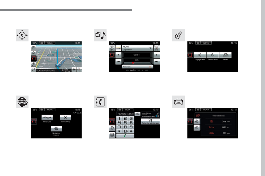
Menus

Settings

Radio Media

Navigation

Driving

Connected services

Telephone

Adjust the settings for sound (balance, 
ambience, ...), colour schemes and the display 
(language, units, date, time, ...).

Select an audio source, a radio station, display 
photographs.

Enter navigation settings and choose a 
destination.

Access to the trip computer.
Activate, deactivate or enter settings for certain 
vehicle functions.

Connect using the "Internet browser".
Operate certain applications on your 
smartphone via MirrorLink

TM

 or CarPlay

®

.

Connect a telephone by Bluetooth

®

.

Access to the CarPlay

®

 function after 

connection of your smartphone by USB cable.

(Depending on equipment)

(Depending on equipment)

Audio and Telematics

288

C4-2_en_Chap10b_SMEGplus_ed02-2015

Level 1

Level 2

Level 3

Navigation

Navigation

Route settings

.

Audio and Telematics

289

C4-2_en_Chap10b_SMEGplus_ed02-2015

Level 1

Level 2

Level 3

Comments

Navigation

Settings

Navigation

Enter destination

Display recent destinations

Calculatory criteria

Fastest

Choose the navigation criteria.
The map displays the route chosen according to 
these criteria.

Shortest

Time/distance
Ecological

Tolls

Ferries

Traffic

Strict-Close

Show route on map

Display the map and start navigation.

Confirm

Save the options.

Save current location

Save the current address.

Stop navigation

Delete the navigation information.

Voice synthesis

Choose the volume for voice and announcement 
of street names.

Diversion

Detour from your initial route by a determined 
distance.

Navigation

Display in text mode

Zoom in.

Zoom out.
Display in full screen mode.
Use the arrows to move the map.
Switch to 2D map.

Audio and Telematics

290

C4-2_en_Chap10b_SMEGplus_ed02-2015

Level 1

Level 2

Level 3

To use the telephone functions, 
refer to the "Telephone

" section.

For managing contacts and 
their addresses, refer to the 
"Telephone

" section.

Navigation

Address

Enter destination

Contacts

.

Audio and Telematics

291

C4-2_en_Chap10b_SMEGplus_ed02-2015

Level 1

Level 2

Level 3

Comments

Navigation

Secondary page

Enter destination

Address

Curr. location

Address settings

Points of Interest

Town centre

Save

Save the current address.

Add waypoint

Add a waypoint to the route.

Navigate to

Press to calculate the route.

Contacts

Addresses

Select a contact then calculate the route.

View

Navigate to

Search for contact

Call

From map

Display the map and zoom to view the roads.

Itinerary

Create, add or delete a waypoint or view the 
itinerary.

Stop

Delete navigation information.

Navigate to

Press to calculate the route.

Audio and Telematics

292

C4-2_en_Chap10b_SMEGplus_ed02-2015

Search for a point of interest

Navigation

Point of interest displayed on the map

Level 1

Level 2

Level 3

.

Audio and Telematics

293

C4-2_en_Chap10b_SMEGplus_ed02-2015

Level 1

Level 2

Level 3

Comments

Navigation

Secondary page

Search for POI

All POIs

List of categories available.
After choosing the category, select the points of 
interest.

Garage

Dining/hotels

Personal

Search

Save the settings.

Navigation

Secondary page

Show POIs

Select all

Choose the display settings for POIs.

Delete

Import POIs

Confirm

Save the options.

Audio and Telematics

294

C4-2_en_Chap10b_SMEGplus_ed02-2015

Moving 
between 
the two 
menus.

Level 1

Level 2

Level 3

Traffic messages

Settings

Diversion

Map settings

Navigation

Map settings

Settings

Settings

.

Audio and Telematics

295

C4-2_en_Chap10b_SMEGplus_ed02-2015

Level 1

Level 2

Level 3

Comments

Navigation

Secondary page

Traffic messages

On the route

Settings for the choice of messages and the 
filter radius.

Around vehicle

Near destination

Detour

Detour over a distance

Recalculate route

Finish

Save your selections.

Navigation

Secondary page

Map settings

Orientation

Flat view north heading

Choose the display and orientation of the 
map.

Flat view vehicle heading

Perspective view

Maps

Aspect

"Day" map colour

"Night" map colour

Automatic day/night

Confirm

Save the settings.

Navigation

Secondary page

Settings

Route settings

Enter settings and choose the volume for the 
voice and announcement of street names.

Voice

Alert!

Traffic options

Confirm

Save your selections.

Audio and Telematics

296

C4-2_en_Chap10b_SMEGplus_ed02-2015

Navigation - Guidance

Choosing a new destination

Select "Enter destination

".

Select "Save" to save the address 
entered as a contact entry.
The system allows up to 200 entries.

Select "Confirm

".

Press "Show route on map" to start 
navigation.

Select "Address

".

Select the "Country:

" from the 

list offered, then in the same 
way the "City:" or its post 
code, the "Road:", the "N°:

".

Confirm each time.

Select "Navigate to

".

Choose the restriction criteria: 
"Include tollroads", "Include 
ferries
", "Traffic", "Strict", "Close

".

Choose the navigation criteria: 
"Fastest" or "Shortest" or "Time/
distance
" or "Ecological

".

To delete navigation information, 
press "Settings

".

Press "Stop navigation

".

To resume navigation press 
"Settings

".

Press "Resume navigation

".

Press on Navigation to display the 
primary page.

Press on the secondary page.

Towards a new destination

Or

.

Audio and Telematics

297

C4-2_en_Chap10b_SMEGplus_ed02-2015

Towards a recent destination

Select "Enter destination

".

Select an address from 
the list offered.

Press on Navigation to display the 
primary page.

Press on the secondary page.

Select "Navigate to

".

Towards a contact

Select "Enter destination

".

Select "Contacts

".

Press on Navigation to display the 
primary page.

Press on the secondary page.

Select a destination from 
the contacts in the list 
offered.

Select "Navigate to

".

Select the criteria then "Confirm" to 
start navigation.

To be able to use navigation "towards 
a contact in the directory", it is first 
necessary to enter the address for your 
contact.

Select the criteria then "Confirm" or 
press "Show route on map" to start 
navigation.

Audio and Telematics

298

C4-2_en_Chap10b_SMEGplus_ed02-2015

Towards GPS coordinates

Select "Enter destination

".

Select "Address

".

Enter the "Longitude:
then the "Latitude:

".

Select "Navigate to

".

Select the criteria then "Confirm" or 
press "Show route on map" to start 
navigation.

Press on Navigation to display the 
primary page.

Press on the secondary page.

Towards a point on the map

Select "Enter destination

".

Select "From map

".

Press on Navigation to display the 
primary page.

Press on the secondary page.

Zooming in on the map shows points with 
information.

A long press on a point opens its content.

Towards points of interest (POI)

Points of Interest (POI) are listed in different 
categories.

Press on Navigation to display the 
primary page.

Press on the secondary page.

Select "Search for POI

".

Select "All POIs"

Or

"Garage",

Or

"Dining/hotels

".

.

Audio and Telematics

299

C4-2_en_Chap10b_SMEGplus_ed02-2015

An annual mapping update allows  
new points of interest to be presented 
to you.
You can also update the Risk areas / 
Danger areas every month.
The detailed procedure is available on:
http://citroen.navigation.com.

Audio and Telematics

300

C4-2_en_Chap10b_SMEGplus_ed02-2015

Hazard zone / Danger zone 
alert settings

Press on Navigation to display the 
primary page.

Press on the secondary page.

Select "Settings

".

Select "Alarm!

".

It is then possible to activate Risk Areas alerts 
then:
-  "Audible warning"
-  "Alert only when navigating"

"Alert only for overspeed"

-  "Display speed limits"
-  Timing: the choice of timing allows the 

time before giving a Risk Area alert to be 
defined.

Select "Confirm

".

This series of alerts and displays is 
only available if Risk Areas have first 
been downloaded and installed on the 
system.

Traffic

Traffic information

Display of messages

Press on Navigation to display the 
primary page.

Press on the secondary page.

Select "Traffic messages

".

Choose filter settings for:

"On the route",

"Around",

"Near destination", filters to fine-
tune the list of messages.

Press again to remove the filter.

.

Audio and Telematics

301

C4-2_en_Chap10b_SMEGplus_ed02-2015

Select the message from 
the list offered.

Select the magnifying glasses to 
have voice information.

Setting filters

Press on Navigation to display the 
primary page.

Press on the secondary page.

Select "Settings

".

Select "Info options

".

Select:
- "Warn of new messages",
- "Speak messages

".

Then enter the filter radius.

Select "Confirm

".

We recommend a filter radius of:
-  12 miles (20 km) in urban areas,
-  30 miles (50 km) on motorways.

TMC (Traffic Message Channel) 
messages on GPS-Navigation contain 
traffic information transmitted in real 
time.

The TA (Traffic Announcement) 
function gives priority to TA alert 
messages. To operate, this function 
needs good reception of a radio station 
transmitting this type of message. 
When a traffic report is transmitted, 
the current audio source is interrupted 
automatically to play the TA message. 
Normal playback of the audio source 
resumes at the end of the transmission 
of the message.

Receiving TA messages

Press on Navigation to display the 
primary page.

Press on the secondary page.

Select "Settings

".

Select "Voice

".

Activate / Deactivate "Traffic 
(TA)

".

Audio and Telematics

302

C4-2_en_Chap10b_SMEGplus_ed02-2015

Radio Media

Level 1

Level 2

List of FM stations

Preset


Content   ..  17  18  19  20   ..