JEPPESEN GENERAL AIRWAY MANUAL (Issue Date 1 JUL 21) - page 16
 

  Index      Manuals     JEPPESEN GENERAL AIRWAY MANUAL (Issue Date 1 JUL 21)


Search            copyright infringement  


Content      ..     14      15      16      17     ..


JEPPESEN GENERAL AIRWAY MANUAL (Issue Date 1 JUL 21) - page 16


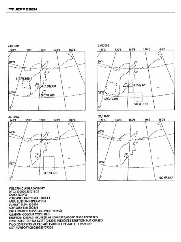
Appendix 1. Model VAG – Volcanic Ash Advisory Information in

Graphical Format

METEOROLOGY SERVICE FOR INTERNATIONAL AIR

NAVIGATION

481

METEOROLOGICAL SERVICE FOR INTERNATIONAL AIR NAVIGATION - ANNEX 3

Appendix 1. Model STC – SIGMET for Tropical Cyclone in Graphical

Format

METEOROLOGY SERVICE FOR INTERNATIONAL AIR

NAVIGATION

482

METEOROLOGICAL SERVICE FOR INTERNATIONAL AIR NAVIGATION - ANNEX 3

Appendix 1. Model SVA – SIGMET for Volcanic Ash in Graphical

Format

METEOROLOGY SERVICE FOR INTERNATIONAL AIR

NAVIGATION

483

METEOROLOGICAL SERVICE FOR INTERNATIONAL AIR NAVIGATION - ANNEX 3

Appendix 1. Model SGE – SIGMET for Phenomena other than Tropical

Cyclone and Volcanic Ash in Graphical Format

METEOROLOGY SERVICE FOR INTERNATIONAL AIR

NAVIGATION

484

METEOROLOGICAL SERVICE FOR INTERNATIONAL AIR NAVIGATION - ANNEX 3

Appendix 1. Model SN – Sheet of Notations used in Flight

Documentation

SYMBOLS FOR SIGNIFICANT WEATHER

NOTE: Height indications between which phenomena are expected, top above base as per chart
legend.

Tropical cyclone

Drizzle

Severe squall line

1

Rain

Moderate turbulence

Snow

Severe turbulence

Shower

Hail

Mountain waves

Widespread blowing snow

Moderate aircraft icing

Severe sand or dust haze

Severe aircraft icing

Widespread sandstorm or dust-
storm

Widespread fog

Widespread haze

1.

METEOROLOGY SERVICE FOR INTERNATIONAL AIR

NAVIGATION

485

METEOROLOGICAL SERVICE FOR INTERNATIONAL AIR NAVIGATION -- ANNEX 3

Radioactive materials in the at-
mosphere

2

Widespread mist

Volcanic eruption

3

Widespread smoke

Mountain obscuration

Freezing precipitation

4

In flight documentation for flights operating up to FL100, this symbol refers to “squall line”.
The following Information should be included in a separate text box on the chart: radioactive
materials in the atmosphere symbol; latitude/longitude of release site; and (if known) the name
of the site of the radioactive source. In addition, the legend of SIGWX charts on which a
release of radiation is indicated should contain “CHECK SIGMET AND NOTAM FOR RDOACT
CLD’. The center of the radioactive materials in the atmosphere symbol should be placed on
significant weather charts at the latitude/longitude site of the radioactive source.
The following information should be included in a separate text box on the chart: volcanic erup-
tion symbol; the name of the volcano (if known); and the latitude/longitude of the eruption. In
addition, the legend of SIGWX charts should indicate “CHECK SIGMET, ADVISORIES FOR
TC AND VA, AND ASHTAM AND NOTAM FOR VA”. The dot on the base of the volcanic erup-
tion symbol should be placed on significant weather charts at the latitude/longitude site of the
volcanic event.
This symbol does not refer to icing due to precipitation coming into contact with an aircraft
which is at a very low temperature.

FRONTS AND CONVERGENCE ZONES AND OTHER

SYMBOLS USED

Cold front at the surface

Position, speed and level of
max. wind

Warm front at the surface

Convergence line

Occluded front at the sur-
face

Freezing level

Quasi-stationary front at
the surface

Intertropical convergence
zone

1

2

3

4

2.

METEOROLOGY SERVICE FOR INTERNATIONAL AIR

NAVIGATION

486

METEOROLOGICAL SERVICE FOR INTERNATIONAL AIR NAVIGATION -- ANNEX 3

Tropopause high

State of the sea

Tropopause low

Sea surface temperature

Tropopause level

Widespread strong surface
wind

1

Wind arrows indicate the maximum wind in jet and the flight level at which it occurs. If the maxi-
mum wind speed is 60m/s (120kt) or more, the flight levels between which winds are greater
than 40m/s (80kt) is placed below the maximum wind level. In the example, winds are greater
than 40m/s (80kt) between FL220 and FL400. The heavy line delineating the jet axis begins/
ends at the points where a wind speed of 40m/s (80kt) is forecast.   Symbol used whenever the
height of the jet axis changes by +/-3000ft or the speed changes by +/-20kt.

This symbol refers to widespread surface wind speeds exceeding 15m/s (30kt).

ABBREVIATIONS USED TO DESCRIBE CLOUDS

TYPE

CI = Cirrus

AS = Altostratus

ST = Stratus

CC = Cirrocumulus

NS = Nimbostratus

CU = Cumulus

CS = Cirrostratus

SC = Stratocumulus

CB = Cumulonimbus

AC = Altocumulus


AMOUNT

Clouds except CB:

FEW = few (1/8 to 2/8);
SCT = scattered (3/8 to 4/8);
BKN = broken (5/8 to 7/8);
OVC = overcast (8/8ths).

CB only:

ISOL = individual CBs (isolated);

1

3.

3.1

3.2

METEOROLOGY SERVICE FOR INTERNATIONAL AIR

NAVIGATION

487

METEOROLOGICAL SERVICE FOR INTERNATIONAL AIR NAVIGATION -- ANNEX 3

OCNL = well separated CBs (occasional);
FRQ = CBs with little or no separation (frequent);
EMBD = CBs embedded in layers of other clouds or concealed by haze (embedded).

HEIGHTS

Heights are indicated on SWH and SWM charts in flight levels (FL), top over base. When XXX is
used, tops or bases are outside the layer of the atmosphere to which the chart applies.
In SWL charts:

a. Heights are indicated as altitudes above mean sea level.
b. The abbreviation SFC is used to indicate ground level.

DEPICTING OF LINES AND SYSTEMS ON SPECIFIC CHARTS

SWH AND SWM – SIGNIFICANT WEATHER CHARTS (HIGH AND

MEDIUM)

Scalloped line

= demarcation of areas of significant weather

Heavy broken line

= delineation of area of CAT

Heavy solid line interrupted by
wind arrow and flight level

= position of jet stream axis with indication of wind direction,

speed in kt or km/h and height in flight levels. The vertical
extent of the jet stream is indicated (in flight levels), e.g.
FL270 accompanied by 240/290 indicates that the jet ex-
tends from FL240 to FL290.

Flight levels inside small rectan-
gles

= height in flight levels of tropopause at spot locations; e.g.,

. Low and High points of the tropopause topography

are indicated by the letters L or H respectively inside a
pentagon with the height in flight levels.
Display explicit FL for JET dephts and tropopause height
even if outside forecast bounds.

SWL – SIGNIFICANT WEATHER CHART (LOW LEVEL)

X

=

position of pressure centers given in hectopascals

L

=

center of low pressure

H

=

center of high pressure

Scalloped lines

=

demarcation of area of significant weather

3.3

4.

4.1

4.2

METEOROLOGY SERVICE FOR INTERNATIONAL AIR

NAVIGATION

488

METEOROLOGICAL SERVICE FOR INTERNATIONAL AIR NAVIGATION -- ANNEX 3

Dashed lines

=

altitude of 0°C isotherm in feet (hectofeet) or meters

NOTE: 0°C level may also be indicated by; 

 i.e.,

0°C level is at an altitude of 6000ft.

Figures on arrows

=

speed in kt or km/h of movement of frontal systems, de-
pressions or anticyclones

Figure inside the state of the
sea symbol

=

total wave height in feet or meters

Figure inside the sea surface
temperature symbol

=

sea surface temperature in °C

Figures inside the strong sur-
face wind symbol

=

wind in kt or km/h

ARROWS, FEATHERS AND PENNANTS

Arrows indicate direction. Number of pennants and/or feathers correspond to speed.

EXAMPLE:

1

270°/115kt (equivalent to 57.5m/s).
Pennants correspond to 50kt or 25m/s.
Feather correspond to 10kt or 5m/s.
Half-feather correspond to 5kt or 2.5m/s.

A conversion factor of 1 to 2 is used.

4.3

1

METEOROLOGY SERVICE FOR INTERNATIONAL AIR

NAVIGATION

489

METEOROLOGICAL SERVICE FOR INTERNATIONAL AIR NAVIGATION -- ANNEX 3

Appendix 2. Technical Specifications related to Global Systems,

Supporting Centers and Meteorological Offices

Table A2-1. Template for Advisory Message for Volcanic Ash

Key:

M

=

inclusion mandatory, part of every message


O

=

inclusion optional


C

=

inclusion conditional, included whenever applicable


=

=

a double line indicates that the text following it should be placed on the sub-
sequent line

NOTE 1: The ranges and resolutions for the numerical elements included in advisory messages
for volcanic ash are shown in Appendix 6, Table A6-4.
NOTE 2: The explanations for the abbreviations can be found in the Procedures for Air Navigation
Services - ICAO Abbreviations and Codes (PANS-ABC, Doc 8400).
NOTE 3: Inclusion of a “colon” after each element heading is mandatory.
NOTE 4: The numbers 1 to 19 are included only for clarity and they are not part of the advisory
message, as shown in the example.

Table A2-1. Template for Advisory Message for Volcanic Ash

Element

Detailed Content

Template(s)

Examples

1 Identification of

the type of
message (M)

Type of message

VA ADVISORY

VA ADVISORY

2 Status indica-

tor (C)

1

Indicator of test or ex-
ercise

STATUS: TEST or EXER STATUS:

TEST
EXER

3 Time of origin

(M)

Year, month, day,
time in UTC

DTG:

nnnnnnnn/
nnnnZ

DTG:

20080923/0
130Z

4 Name of VAAC

(M)

Name of VAAC

VAAC:

nnnnnnnnnnnn VAAC:

TOKYO

5 Name of volca-

no (M)

Name and IAVCEI

2

number of volcano

VOLCA-
NO:

nnnnnnnnnnnn
nn nnnnnnnn
[nnnnnn]

VOLCA-
NO:

KARYM-
SKY
1000-13


or UNKNOWN
or UNNAMED


UNNAMED

METEOROLOGY SERVICE FOR INTERNATIONAL AIR

NAVIGATION

490

METEOROLOGICAL SERVICE FOR INTERNATIONAL AIR NAVIGATION - ANNEX 3

Table A2-1. Template for Advisory Message for Volcanic Ash (continued)

Element

Detailed Content

Template(s)

Examples

6 Location of vol-

cano (M)

Location of volcano in
degrees and minutes

PSN:

Nnnnn or
Snnnn
Wnnnnn or
Ennnnn or

PSN:

N5403
E15927


UNKNOWN


UNKNOWN

7 State or region

(M)

State, or region if ash
is not reported over a
State

AREA:

nnnnnnnnnn
nnnnnn

AREA:

RUSSIA

8 Summit eleva-

tion (M)

Summit elevation in
m (or ft)

SUMMIT
ELEV:

nnnnM (or
nnnnnFT)

SUMMIT
ELEV:

1536M

9 Advisory num-

ber (M)

Year in full and mes-
sage number (sepa-
rate sequence for
each volcano)

ADVISO-
RY NR:

nnnn/[n][n][n]n

ADVISO-
RY NR:

2008/4

1
0

Information
source (M)

Information source
using free text

INFO
SOURCE:

Free text up to
32 characters

INFO
SOURCE:

MTSAT-1R
KVERT
KEMSD

1
1

Colour code
(O)

Aviation colour code

AVIA-
TION
COLOUR
CODE:

RED or OR-
ANGE or YEL-
LOW or
GREEN or UN-
KNOWN or
NOT GIVEN or
NIL

AVIATION
COLOUR
CODE:

RED

1
2

Eruption de-
tails (M)

Eruption details (in-
cluding date/time of
eruption(s))

ERUP-
TION DE-
TAILS:

Free text up to
64 characters
or UNKNOWN

ERUP-
TION DE-
TAILS:

ERUPTION
AT
20080923/0
000Z FL300
REPOR-
TED

1
3

Time of obser-
vation (or esti-
mation) of ash
(M)

Day and time (in
UTC) of observation
(or estimation) of vol-
canic ash

OBS (or
EST) VA
DTG:

nn/nnnnZ

OBS VA
DTG:

23/0100Z

METEOROLOGY SERVICE FOR INTERNATIONAL AIR

NAVIGATION

491

METEOROLOGICAL SERVICE FOR INTERNATIONAL AIR NAVIGATION - ANNEX 3

Table A2-1. Template for Advisory Message for Volcanic Ash (continued)

Element

Detailed Content

Template(s)

Examples

1
4

Observed or
estimated ash
cloud (M)

Horizontal (in de-
grees and minutes)
and vertical extent at
the time of observa-
tion of the observed
or estimated ash
cloud or, if the base is
unknown, the top of
the observed or esti-
mated ash cloud;
Movement of the ob-
served or estimated
ash cloud

OBS VA
CLD or
EST VA
CLD:

TOP FLnnn or
SFC/FLnnn or
FLnnn/nnn
[nnKM WID
LINE

3

 BTN

[nnNM WID
LINE BTN)]
Nnn[nn] or
Snn[nn]
Wnnn[nn] or
Ennn[nn] -
Nnn[nn] or
Snn[nn]
Wnnn[nn] or
Ennn[nn] -
Nnn[nn] or
Snn[nn]
Wnnn[nn] or
Ennn[nn] -
[Nnn[nn] or
Snn[nn]
Wnnn[nn] or
Ennn[nn] -
Nnn[nn] or
Snn[nn]
Wnnn[nn] or
Ennn[nn]] -
MOV N nnKMH
(or KT) or
MOV NE
nnKMH (or KT)
or
MOV E nnKMH
(or KT) or
MOV SE
nnKMH (or KT)
or

OBS VA
CLD:

FL250/300
N5400
E15930 -
N5400
E16100 -
N5300
E15945 -
MOV SE
20KT
SFC/FL200
N5130
E16130 -
N5130
E16230 -
N5230
E16230 -
N5230
E16130 -
MOV SE
15KT
TOP FL240
MOV W
40KMH
VA NOT
IDENTIFIA-
BLE FM
SATELLITE
DATA
WIND
FL050/070
180/12MPS

METEOROLOGY SERVICE FOR INTERNATIONAL AIR

NAVIGATION

492

METEOROLOGICAL SERVICE FOR INTERNATIONAL AIR NAVIGATION - ANNEX 3

Table A2-1. Template for Advisory Message for Volcanic Ash (continued)

Element

Detailed Content

Template(s)

Examples

MOV S nnKMH
(or KT) or


MOV SW
nnKMH (or KT)
or
MOV W nnKMH
(or KT) or


MOV NW
nnKMH (or KT)

4

or


VA NOT IDEN-
TIFIABLE FM


SATELLITE
DATA
WIND
FLnnn/nnn
nnn/nn[n]MPS
(or KT)

5

 or


WIND
FLnnn/nnn
VRBnnMPS (or
KT) or WIND
SFC/FLnnn
nnn/nn(n)MPS
(or KT) or
WIND SFC/
FLnnn
VRBnnMPS (or
KT)


METEOROLOGY SERVICE FOR INTERNATIONAL AIR

NAVIGATION

493

METEOROLOGICAL SERVICE FOR INTERNATIONAL AIR NAVIGATION - ANNEX 3

Table A2-1. Template for Advisory Message for Volcanic Ash (continued)

Element

Detailed Content

Template(s)

Examples

1
5

Forecast
height and po-
sition of the
ash clouds
(+6HR) (M)

Day and time (in
UTC) (6 hours from
the “Time of observa-
tion (or estimation) of
ash” given in Item
13);
Forecast height and
position in degrees
and minutes) for each
cloud mass for that
fixed valid time

FCST VA
CLD
+6HR:

nn/nnnnZ
SFC or FLnnn/
[FL]nnn
[nnKM WID
LINE

3

 BTN

(nnNM WID
LINE BTN)]
Nnn[nn] or
Snn[nn]
Wnnn[nn] or
Ennn[nn] -
Nnn[nn] or
Snn[nn]
Wnnn[nn] or
Ennn[nn][ -
Nnn[nn] or
Snn[nn]
Wnnn[nn] or
Ennn[nn] -
Nnn[nn] or
Snn[nn]
Wnnn[nn] or
Ennn[nn] -
Nnn[nn] or
Snn[nn]
Wnnn[nn] or
Ennn[nn]] 

4

 or

NO VA EXP or
NOT AVBL or
NOT PROVI-
DED

FCST VA
CLD
+6HR:

23/0700Z
FL250/350
N5130
E16030-
N5130
E16230 -
N5330
E16230 -
N5330
E16030 -
SFC/FL180
N4830
E16330 -
N4830
E16630 -
N5130
E16630 -
N5130
E16330
NO VA EXP
NOT AVBL
NOT PRO-
VIDED

METEOROLOGY SERVICE FOR INTERNATIONAL AIR

NAVIGATION

494

METEOROLOGICAL SERVICE FOR INTERNATIONAL AIR NAVIGATION - ANNEX 3

Table A2-1. Template for Advisory Message for Volcanic Ash (continued)

Element

Detailed Content

Template(s)

Examples

1
6

Forecast
height and po-
sition of the
ash clouds
(+12HR) (M)

Day and time (in
UTC) (12 hours from
the “Time of observa-
tion (or estimation) of
ash” given in Item
13);
Forecast height and
position (in degrees
and minutes) for each
cloud mass for that
fixed valid time

FCST VA
CLD
+12HR:

nn/nnnnZ
SFC or FLnnn/
[FL]nnn
[nnKM WID
LINE

3

 BTN

(nnNM WID
LINE BTN)]
Nnn[nn] or
Snn[nn]
Wnnn[nn] or
Ennn[nn] -
Nnn[nn] or
Snn[nn]
Wnnn[nn] or
Ennn[nn][ -
Nnn[nn] or
Snn[nn]
Wnnn[nn] or
Ennn[nn] -
Nnn[nn] or
Snn[nn]
Wnnn[nn] or
Ennn[nn] -
Nnn[nn] or
Snn[nn]
Wnnn[nn] or
Ennn[nn]] 

4

 or

NO VA EXP or
NOT AVBL or
NOT PROVI-
DED

FCST VA
CLD
+12HR:

23/1300Z
SFC/FL270
N4830
E16130 -
N4830
E16600 -
N5300
E16600 -
N5300
E16130 -
NO VA EXP
NOT AVBL
NOT PRO-
VIDED

METEOROLOGY SERVICE FOR INTERNATIONAL AIR

NAVIGATION

495

METEOROLOGICAL SERVICE FOR INTERNATIONAL AIR NAVIGATION - ANNEX 3

Table A2-1. Template for Advisory Message for Volcanic Ash (continued)

Element

Detailed Content

Template(s)

Examples

1
7

Forecast
height and po-
sition of the
ash clouds
(+18HR) (M)

Day and time (in
UTC) (18 hours from
the “Time of observa-
tion (or estimation) of
ash” given in Item
13);
Forecast height and
position (in degrees
and minutes) for each
cloud mass for that
fixed valid time

FCST VA
CLD
+18HR:

nn/nnnnZ
SFC or FLnnn/
[FL]nnn
[nnKM WID
LINE

3

 BTN

(nnNM WID
LINE BTN)]
Nnn[nn] or
Snn[nn]
Wnnn[nn] or
Ennn[nn] -
Nnn[nn] or
Snn[nn]
Wnnn[nn] or
Ennn[nn][ -
Nnn[nn] or
Snn[nn]
Wnnn[nn] or
Ennn[nn] -
Nnn[nn] or
Snn[nn]
Wnnn[nn] or
Ennn[nn] -
Nnn[nn] or
Snn[nn]
Wnnn[nn] or
Ennn[nn]]

4

 or

NO VA EXP or
NOT AVBL or
NOT PROVI-
DED

FCST VA
CLD
+18HR:

23/1900Z
NO VA EXP
NOT AVBL
NOT PRO-
VIDED

METEOROLOGY SERVICE FOR INTERNATIONAL AIR

NAVIGATION

496

METEOROLOGICAL SERVICE FOR INTERNATIONAL AIR NAVIGATION - ANNEX 3

Table A2-1. Template for Advisory Message for Volcanic Ash (continued)

Element

Detailed Content

Template(s)

Examples

1
8

Remarks (M)

Remarks, as neces-
sary

RMK:

Free text up to
256 characters
or
NIL

RMK:

LATEST
REP FM
KVERT
(0120Z) IN-
DICATES
ERUPTION
HAS
CEASED.
TWO DIS-
PERSING
VA CLD
ARE EVI-
DENT ON
SATELLITE
IMAGERY
NIL

1
9

Next advisory
(M)

Year, month, day and
time in UTC

NXT AD-
VISORY:

nnnnnnnn/
nnnnZ
or
NO LATER
THAN
nnnnnnnn/
nnnnZ
or
NO FURTHER
ADVISORIES
or
WILL BE IS-
SUED BY
nnnnnnnn/
nnnnZ

NXT ADVI-
SORY:

20080923/0
730Z
NO LATER
THAN
nnnnnnnn/
nnnnZ
NO FUR-
THER AD-
VISORIES
WILL BE
ISSUED BY
nnnnnnnn/
nnnnZ

Used only when the message issued to indicate that a test or an exercise is taking place. When
the word 'TEST" or the abbreviation 'EXER" is included, the message may contain information
that should not be used operationally or will otherwise end immediately after the word 'TEST'.
[Applicable 7 November 2019]
International Association of Volcanology and Chemistry of the Earth's Interior (IAVCEI).

1

2

METEOROLOGY SERVICE FOR INTERNATIONAL AIR

NAVIGATION

497

METEOROLOGICAL SERVICE FOR INTERNATIONAL AIR NAVIGATION - ANNEX 3

A straight line between two points drawn on a map in the Mercator projection or a straight line
between two points which crosses lines of longitude at a constant angle.
Up to 4 selected layers.
If ash reported (e.g. AIREP) but not identifiable from satellite data.

Example A2-1. Advisory Message for Volcanic Ash

VA ADVISORY


DTG:

20080923/0130Z

VAAC:

TOKYO

VOLCANO:

KARYMSKY 1000-13

PSN:

N5403 E15927

AREA:

RUSSIA

SUMMIT ELEV:

1536M

ADVISORY NR:

2008/4

INFO SOURCE:

MTSAT-1R KVERT KEMSD

AVIATION COLOUR CODE:

RED

ERUPTION DETAILS:

ERUPTION AT 20080923/0000Z FL300 REPORTED

OBS VA DTG:

23/0100Z

OBS VA CLD:

FL250/300 N5400 E15930 - N5400 E16100 - N5300 E15945
MOV SE 20KT
SFC/FL200 N5130 E16130 - N5130 E16230 - N5230 E16230 -
N5230 E16130 MOV SE 15KT

FCST VA CLD +6HR:

23/0700Z FL250/350 N5130 E16030 - N5130 E16230 - N5330
E16230 - N5330 E16030 SFC/FL180 N4830 E16330 - N4830
E1660 - N5130 E16630 - N5130 E16330

FCST VA CLD +12HR:

23/1300Z SFC/FL270 N4830 E16130 - N4830 E16600 - N5300
E16600 - N5300 E1630

FCST VA CLD +18HR:

23/1900Z NO VA EXP

RMK:

LATEST REP FM KVERT (0120Z) INDICATES ERUPTION
HAS CEASED. TWO DISPERSING VA CLD ARE EVIDENT
ON SATELLITE IMAGERY

NXT ADVISORY:

20080923/0730Z

3

4

5

METEOROLOGY SERVICE FOR INTERNATIONAL AIR

NAVIGATION

498

METEOROLOGICAL SERVICE FOR INTERNATIONAL AIR NAVIGATION - ANNEX 3

Table A2-2. Template for Advisory Message for Tropical Cyclones

Key:

M

=

inclusion mandatory, part of every message


C

=

inclusion conditional, included whenever applicable


=

=

a double line indicates that the text following it should be placed on the sub-
sequent line

NOTE 1: The ranges and resolutions for the numerical elements included in advisory messages
for tropical cyclones are shown in Appendix 6, Table A 6-4.
NOTE 2: The explanations for the abbreviations can be found in the Procedures for Air Navigation
Services - ICAO Abbreviations and Codes (PANS-ABC, Doc 8400).
NOTE 3: All the elements are mandatory.
NOTE 4: Inclusion of a "colon" after each element heading is mandatory.
NOTE 5: The numbers 1 to 21are included only for clarity and they are not part of the advisory
message, as shown in the example.

Table A2-2. Template for Advisory Message for Tropical Cyclones

Element

Detailed Content

Template(s)

Examples

1 Identification of

the type of
message (M)

Type of message

TC ADVISORY

TC ADVISORY

2 Status indica-

tor (C)

1

Indicator of test or ex-
ercise

STA-
TUS:

TEST or EXER

STA-
TUS:

TEST
EXER

3 Time of origin

(M)

Year, month, day,
time in UTC of issue

DTG: nnnnnnnn/nnnnZ DTG:

20040925/1900Z

4 Name of TCAC

(M)

Name of TCAC (loca-
tion indicator or full
name)

TCAC: nnnn or

nnnnnnnnnn

TCAC: YUFO

2

MIAMI

5 Name of tropi-

cal cyclone (M)

Name of tropical cy-
clone or “NN” for un-
named tropical cy-
clone

TC:

nnnnnnnnnnnn or
NN

TC:

GLORIA

6 Advisory num-

ber (M)

Year in full and mes-
sage number (sepa-
rate sequence for
each cyclone)

ADVI-
SORY
NR:

nnnn/[n][n][n]n

ADVI-
SORY
NR:

2004/13

METEOROLOGY SERVICE FOR INTERNATIONAL AIR

NAVIGATION

499

METEOROLOGICAL SERVICE FOR INTERNATIONAL AIR NAVIGATION - ANNEX 3

Table A2-2. Template for Advisory Message for Tropical Cyclones (continued)

Element

Detailed Content

Template(s)

Examples

7 Observed posi-

tion of centre
(M)

Day and time in UTC
and position of the
centre of the tropical
cyclone (in degrees
and minutes)

OBS
PSN:

nn/nnnnZ
Nnn[nn] or
Snn[nn]
Wnnn[nn] or
Ennn[nn]

OBS
PSN:

25/1800Z
N2706 W07306

8 Observed CB

cloud

3

 (C)

Location of CB cloud
referring to latitude
and longitude (in de-
grees and minutes)
and vertical extent
(flight level)

CB:

WI nnnKM (or
nnnNM) OF TC
CENTER or
WI

4

 Nnn[nn] or

Snn[nn] Wnnn[nn]
or Ennn[nn]-
Nnn[nn] or
Snn[nn] Wnnn[nn]
or Ennn[nn]-
Nnn[nn] or
Snn[nn] Wnnn[nn]
or Ennn[nn]-
[Nnn[nn] or
Snn[nn] Wnnn[nn]
or Ennn[nn]-
Nnn[nn] or
Snn[nn] Wnnn[nn]
or Ennn[nn]]
and
TOP [ABV or
BLW] FLnnn

CB:

WI 250NM OF
TC CENTRE
TOP FL500

9 Direction and

speed of
movement (M)

Direction and speed
of movement given in
sixteen compass
points and km/h (or
kt), respectively, or
stationary (< 2km/h
(1kt))

MOV: N nnKMH (or KT)

or
NNE nnKMH (or
KT) or
NE nnKMH (or
KT) or
ENE nnKMH (or
KT) or

MOV: NW 20KMH

METEOROLOGY SERVICE FOR INTERNATIONAL AIR

NAVIGATION

500

METEOROLOGICAL SERVICE FOR INTERNATIONAL AIR NAVIGATION - ANNEX 3

Table A2-2. Template for Advisory Message for Tropical Cyclones (continued)

Element

Detailed Content

Template(s)

Examples


E nnKMH (or KT)
or
ESE nnKMH (or
KT) or


SE nnKMH (or
KT) or
SSE nnKMH (or
KT) or
S nnKMH (or KT)
or


SSW nnKMH (or
KT) or
SW nnKMH (or
KT) or


WSW nnKMH (or
KT) or
W nnKMH (or KT)
or
WNW nnKMH (or
KT) or


NW nnKMH (or
KT) or
NNW nnKMH (or
KT)
or STNR


1
0

Central pres-
sure (M)

Central pressure (in
hPa)

C:

nnnHPA

C:

965HPA

1
1

Maximum sur-
face wind (M)

Maximum surface
wind near the centre
(mean over 10 mi-
nutes, in m/s (or kt))

MAX
WIND:

nn[n]MPS
(or nn[n]KT)

MAX
WIND:

22MPS

METEOROLOGY SERVICE FOR INTERNATIONAL AIR

NAVIGATION

501

METEOROLOGICAL SERVICE FOR INTERNATIONAL AIR NAVIGATION - ANNEX 3

Table A2-2. Template for Advisory Message for Tropical Cyclones (continued)

Element

Detailed Content

Template(s)

Examples

1
2

Forecast of
centre position
(+6HR) (M)

Day and time (in
UTC) (6 hours from
the “DTG” given in
Item 2);
Forecast position (in
degrees and minutes)
of the centre of the
tropical cyclone

FCST
PSN
+6HR:

nn/nnnnZ
Nnn[nn] or
Snn[nn]
Wnnn(nn) or
Ennn[nn]

FCST
PSN
+6HR:

25/2200Z
N2748 W07350

1
3

Forecast of
maximum sur-
face wind
(+6HR) (M)

Forecast of maximum
surface wind (6 hours
after the “DTG” given
in Item 3)

FCST
MAX
WIND
+6HR:

nn[n]MPS
(or nn[n]KT)

FCST
MAX
WIND
+6HR:

22MPS

1
4

Forecast of
centre position
(+12HR) (M)

Day and time (in
UTC) (12 hours from
the “DTG” given in
Item 3);
Forecast position (in
degrees and minutes)
of the centre of the
tropical cyclone

FCST
PSN
+12H
R:

nn/nnnnZ
Nnn[nn] or
Snn[nn]
Wnnn(nn) or
Ennn[nn]

FCST
PSN
+12HR
:

26/0400Z
N2830 W07430

1
5

Forecast of
maximum sur-
face wind
(+12HR) (M)

Forecast of maximum
surface wind (12
hours after the “DTG”
given in Item 3)

FCST
MAX
WIND
+12H
R:

nn[n]MPS
(or nn[n]KT)

FCST
MAX
WIND
+12HR
:

22MPS

1
6

Forecast of
centre position
(+18HR) (M)

Day and time (in
UTC) (18 hours from
the “DTG” given in
Item 3);
Forecast position (in
degrees and minutes)
of the centre of the
tropical cyclone

FCST
PSN
+18H
R:

nn/nnnnZ
Nnn[nn] or
Snn[nn]
Wnnn(nn) or
Ennn[nn]

FCST
PSN
+18HR
:

26/1000Z
N2852 W07500

1
7

Forecast of
maximum sur-
face wind
(+18HR) (M)

Forecast of maximum
surface wind (18
hours after the “DTG”
given in Item 3)

FCST
MAX
WIND
+18H
R:

nn[n]MPS
(or nn[n]KT)

FCST
MAX
WIND
+18HR
:

21MPS

METEOROLOGY SERVICE FOR INTERNATIONAL AIR

NAVIGATION

502

METEOROLOGICAL SERVICE FOR INTERNATIONAL AIR NAVIGATION - ANNEX 3

Table A2-2. Template for Advisory Message for Tropical Cyclones (continued)

Element

Detailed Content

Template(s)

Examples

1
8

Forecast of
centre position
(+24HR) (M)

Day and time (in
UTC) (24 hours from
the “DTG” given in
Item 3);
Forecast position (in
degrees and minutes)
of the centre of the
tropical cyclone

FCST
PSN
+24H
R:

nn/nnnnZ
Nnn[nn] or
Snn[nn]
Wnnn(nn) or
Ennn[nn]

FCST
PSN
+24HR
:

26/1600Z
N2912 W07530

1
9

Forecast of
maximum sur-
face wind
(+24HR) (M)

Forecast of maximum
surface wind (24
hours after the “DTG”
given in Item 3)

FCST
MAX
WIND
+24H
R:

nn[n]MPS
(or nn[n]KT)

FCST
MAX
WIND
+24HR
:

20MPS

2
0

Remarks (M)

Remarks, as neces-
sary

RMK: Free text up to

256 characters
or
NIL

RMK:

NIL

2
1

Expected time
of issuance of
next advisory
(M)

Expected year,
month, day and time
(in UTC) of issuance
of next advisory

NXT
MSG:

[BFR] nnnnnnnn/
nnnnZ
or
NO MSG EXP

NXT
MSG:

20040925/2000Z

Used only when the message issued to indicate that a test or an exercise is taking place. When
the word "TEST" or the abbreviation "EXER" is included, the message may contain information
that should not be used operationally or will otherwise end immediately after the word "TEST".
[Applicable 7 November 2019]
Fictitious location.
In the case of CB clouds associated with a tropical cyclone covering more than one area within
the area of responsibility, this element can be repeated, as necessary.
The number of coordinates should be kept to a minimum and should not normally exceed
seven.

Example A2-2. Advisory Message for Tropical Cyclones

TC ADVISORY
DTG:

20040925/1900Z

TCAC:

YUFO

1

1

2

3

4

METEOROLOGY SERVICE FOR INTERNATIONAL AIR

NAVIGATION

503

METEOROLOGICAL SERVICE FOR INTERNATIONAL AIR NAVIGATION - ANNEX 3

Example A2-2. Advisory Message for Tropical Cyclones (continued)

TC ADVISORY
TC:

GLORIA

ADVISORY NR:

2004/13

OBS PSN:

25/1800Z N2706 WI07306

CB

WI 250NM OF TC CENTRE TOP FL500

MOV:

NW 20KMH

C:

965HPA

MAX WIND:

22MPS

FCST PSN +6HR

25/2200Z N2748 W07350

FCST MAX WIND +6HR

22MPS

FCST PSN +12HR:

26/0400Z N2830 W07430

FCST MAX WIND +12HR:

22MPS

FCST PSN +18HR:

26/1000Z N2852 W07500

FCST MAX WIND +18HR:

21MPS

FCST PSN +24HR:

26/1600Z N2912 W07530

FCST MAX WIND +24HR:

20MPS

RMK:

NIL

NXT MSG:

19970925/2000Z

Ficticious location

Table A2-3. Template for Advisory Message for Space Weather Information

Key:

M

=

inclusion mandatory, part of every message


C

=

inclusion conditional, included whenever applicable;


=

=

a double line indicates that the text following it should be placed on the sub-
sequent line

NOTE 1: The explanations for the abbreviations can be found in the PANS-ABC, Doc 8400).
NOTE 2: The spatial resolutions are shown in Attachment E.
NOTE 3: Inclusion of a colon after each element heading is mandatory.
NOTE 4: The numbers 1 to 14 are included only for clarity and are not part of the advisory mes-
sage, as shown in the examples.

1

METEOROLOGY SERVICE FOR INTERNATIONAL AIR

NAVIGATION

504

METEOROLOGICAL SERVICE FOR INTERNATIONAL AIR NAVIGATION - ANNEX 3

Table A2-3. Template for Advisory Message for Space Weather Information

Element

Detailed Content

Template(s)

Examples

1 Identification of

the type of
message (M)

Type of message

SWX ADVISORY

SWX ADVISORY

2 Status indica-

tor (C)

1

Indicator of test or ex-
ercise

STA-
TUS:

TEST or EXER

STA-
TUS:

TEST
EXER

3 Time of origin

(M)

Year, month, day and
time in UTC

DTG: nnnnnnnn/nnnnZ DTG:

20161108/0100Z

4 Name of

SWXC (M)

Name of SWXC

SWXC
:

Nnnnnnnnnnnn

SWXC
:

DONLON

2

5 Advisory num-

ber (M)

Year in full and
unique message
number

ADVI-
SORY
NR:

nnnn/[n][n][n]n

ADVI-
SORY
NR:

2016/1

6 Number of ad-

visory being
replaced (C)

Number of the previ-
ously issued advisory
being replaced

NR
RPLC:

nnnn/[n][n][n]n

NR
RPLC:

2016/1

7 Space weather

effect and in-
tensity (M)

Effect and intensity of
the space weather
phenomena

SWX
EF-
FECT:

HF COM MOD or
SEV or
SATCOM MOD
or SEV or
GNSS MOD or
SEV or
HF COM MOD or
SEV AND
GNSS MOD or
SEV or
RADIATION

3

MOD or SEV

SWX
EF-
FECT:

HF COM MOD
SATCOM SEV
GNSS SEV
HF COM MOD
AND GNSS MOD
RADIATION MOD

METEOROLOGY SERVICE FOR INTERNATIONAL AIR

NAVIGATION

505

METEOROLOGICAL SERVICE FOR INTERNATIONAL AIR NAVIGATION - ANNEX 3

Table A2-3. Template for Advisory Message for Space Weather Information (continued)

Element

Detailed Content

Template(s)

Examples

8 Observed or

expected
space weather
phenomena
(M)

Day and time (in
UTC) of observed
phenomena (or fore-
cast if phenomena
have yet to occur)
Horizontal extent

3

(latitude bands and
longitude in degrees)
and/or altitude of
space weather phe-
nomena

OBS
(or
FCST)
SWX:

nn/nnnnZ
DAYLIGHT SIDE
or
HNH and/or MNH
and/or EQN
and/or
EQS and/or MSH
and/or HSH
Wnnn(nn) or
Ennn(nn) -
Wnnn(nn) or
Ennn(nn) and/or
ABV FLnnn or
FLnnn - nnn or
Nnn[nn] or
Snn[nn]
Wnnn[nn] or
Ennn[nn] -
Nnn[nn] or
Snn[nn]
Wnnn[nn] or
Ennn[nn] -
Nnn[nn] or
Snn[nn]
Wnnn[nn] or
Ennn[nn] -
[Nnn[nn] or
Snn[nn]
Wnnn[nn] or
Ennn[nn] -
Nnn[nn] or
Snn[nn]
Wnnn[nn] or
Ennn[nn]]
or
NO SWX EXP

OBS
SWX:

08/0100Z DAY-
LIGHT SIDE
08/0100Z HNH
HSH
E18000 - W18000
08/0100Z HNH
HSH
W18000 -
W09000 ABV
FL350

METEOROLOGY SERVICE FOR INTERNATIONAL AIR

NAVIGATION

506

METEOROLOGICAL SERVICE FOR INTERNATIONAL AIR NAVIGATION - ANNEX 3

Table A2-3. Template for Advisory Message for Space Weather Information (continued)

Element

Detailed Content

Template(s)

Examples

9 Forecast of the

phenomena
(+6HR) (M)

Day and time (in
UTC) (6 hours from
the time given in Item
8, rounded to the next
full hour);
Forecast extent
and/or altitude of the
space weather phe-
nomena for that fixed
valid time

FCST
SWX
+6HR:

nn/nnnnZ
DAYLIGHT SIDE
or
HNH and/or MNH
and/or EQN
and/or
EQS and/or MSH
and/or HSH
Wnnn(nn) or
Ennn(nn) -
Wnnn(nn) or
Ennn(nn) and/or
ABV FLnnn or
FLnnn - nnn or
Nnn[nn] or
Snn[nn]
Wnnn[nn] or
Ennn[nn] -
Nnn[nn] or
Snn[nn]
Wnnn[nn] or
Ennn[nn] -
Nnn[nn] or
Snn[nn]
Wnnn[nn] or
Ennn[nn] -
[Nnn[nn] or
Snn[nn]
Wnnn[nn] or
Ennn[nn] -
Nnn[nn] or
Snn[nn]
Wnnn[nn] or
Ennn[nn]]
or
NO SWX EXP or
NOT AVBL

FCST
SWX
+6HR:

08/0700Z DAY-
LIGHT SIDE
08/0700Z HNH
HSH W18000 -
W09000 ABV
FL350
08/0700Z HNH
HSH E18000 -
W18000

METEOROLOGY SERVICE FOR INTERNATIONAL AIR

NAVIGATION

507

METEOROLOGICAL SERVICE FOR INTERNATIONAL AIR NAVIGATION - ANNEX 3

Table A2-3. Template for Advisory Message for Space Weather Information (continued)

Element

Detailed Content

Template(s)

Examples

1
0

Forecast of the
phenomena
(+12HR) (M)

Day and time (in
UTC) (12 hours from
the time given in Item
8, rounded to the next
full hour);
Forecast extent
and/or altitude of the
space weather phe-
nomena for that fixed
valid time

FCST
SWX
+12H
R:

nn/nnnnZ
DAYLIGHT SIDE
or
HNH and/or MNH
and/or EQN
and/or
EQS and/or MSH
and/or HSH
Wnnn(nn) or
Ennn(nn) -
Wnnn(nn) or
Ennn(nn) and/or

FCST
SWX
+12HR
:

08/1300Z DAY-
LIGHT SIDE
08/1300Z HNH
HSH W18000 -
W09000 ABV
FL350
08/1300Z HNH
HSH E18000 -
W18000


ABV FLnnn or
FLnnn - nnn or
Nnn[nn] or
Snn[nn]
Wnnn[nn] or
Ennn[nn] -
Nnn[nn] or
Snn[nn]
Wnnn[nn] or
Ennn[nn] -
Nnn[nn] or
Snn[nn]
Wnnn[nn] or
Ennn[nn] -


[Nnn[nn] or
Snn[nn]
Wnnn[nn] or
Ennn[nn] -


METEOROLOGY SERVICE FOR INTERNATIONAL AIR

NAVIGATION

508

METEOROLOGICAL SERVICE FOR INTERNATIONAL AIR NAVIGATION - ANNEX 3

Table A2-3. Template for Advisory Message for Space Weather Information (continued)

Element

Detailed Content

Template(s)

Examples


Nnn[nn] or
Snn[nn]
Wnnn[nn] or
Ennn[nn]]
or
NO SWX EXP or
NOT AVBL


METEOROLOGY SERVICE FOR INTERNATIONAL AIR

NAVIGATION

509

METEOROLOGICAL SERVICE FOR INTERNATIONAL AIR NAVIGATION - ANNEX 3

Table A2-3. Template for Advisory Message for Space Weather Information (continued)

Element

Detailed Content

Template(s)

Examples

1
1

Forecast of the
phenomena
(+18HR) (M)

Day and time (in
UTC) (18 hours from
the time given in Item
8, rounded to the next
full hour);
Forecast extent
and/or altitude of the
space weather phe-
nomena for that fixed
valid time

FCST
SWX
+18H
R:

nn/nnnnZ
DAYLIGHT SIDE
or
HNH and/or MNH
and/or EQN
and/or
EQS and/or MSH
and/or HSH
Wnnn(nn) or
Ennn(nn) -
Wnnn(nn) or
Ennn(nn) and/or
ABV FLnnn or
FLnnn - nnn or
Nnn[nn] or
Snn[nn]
Wnnn[nn] or
Ennn[nn] -
Nnn[nn] or
Snn[nn]
Wnnn[nn] or
Ennn[nn] -
Nnn[nn] or
Snn[nn]
Wnnn[nn] or
Ennn[nn] -
[Nnn[nn] or
Snn[nn]
Wnnn[nn] or
Ennn[nn] -
Nnn[nn] or
Snn[nn]
Wnnn[nn] or
Ennn[nn]]
or
NO SWX EXP or
NOT AVBL

FCST
SWX
+18HR
:

08/1900Z DAY-
LIGHT SIDE
08/1900Z HNH
HSH W18000 -
W09000 ABV
FL350
08/1300Z HNH
HSH E18000 -
W18000

METEOROLOGY SERVICE FOR INTERNATIONAL AIR

NAVIGATION

510

METEOROLOGICAL SERVICE FOR INTERNATIONAL AIR NAVIGATION - ANNEX 3

Table A2-3. Template for Advisory Message for Space Weather Information (continued)

Element

Detailed Content

Template(s)

Examples

1
2

Forecast of the
phenomena
(+24HR) (M)

Day and time (in
UTC) (24 hours from
the time given in Item
8, rounded to the next
full hour);
Forecast extent
and/or altitude of the
space weather phe-
nomena for that fixed
valid time

FCST
SWX
+24H
R:

nn/nnnnZ
DAYLIGHT SIDE
or
HNH and/or MNH
and/or EQN
and/or
EQS and/or MSH
and/or HSH
Wnnn(nn) or
Ennn(nn) -
Wnnn(nn) or
Ennn(nn) and/or

FCST
SWX
+24HR
:

09/0100Z DAY-
LIGHT SIDE
09/0100Z HNH
HSH W18000 -
W09000 ABV
FL350
09/0100Z HNH
HSH E18000 -
W18000

METEOROLOGY SERVICE FOR INTERNATIONAL AIR

NAVIGATION

511

METEOROLOGICAL SERVICE FOR INTERNATIONAL AIR NAVIGATION - ANNEX 3

Table A2-3. Template for Advisory Message for Space Weather Information (continued)

Element

Detailed Content

Template(s)

Examples


ABV FLnnn or
FLnnn - nnn or
Nnn[nn] or
Snn[nn]
Wnnn[nn] or
Ennn[nn] -
Nnn[nn] or
Snn[nn]
Wnnn[nn] or
Ennn[nn] -
Nnn[nn] or
Snn[nn]
Wnnn[nn] or
Ennn[nn] -
[Nnn[nn] or
Snn[nn]
Wnnn[nn] or
Ennn[nn] -
Nnn[nn] or
Snn[nn]
Wnnn[nn] or
Ennn[nn]]
or
NO SWX EXP or
NOT AVBL


METEOROLOGY SERVICE FOR INTERNATIONAL AIR

NAVIGATION

512

METEOROLOGICAL SERVICE FOR INTERNATIONAL AIR NAVIGATION - ANNEX 3


Content      ..     14      15      16      17     ..